Good Morning. This is Alex Marienthal with the Gallatin National Forest Avalanche Advisory issued on Saturday, February 10th at 7:00 a.m. Today’s advisory is sponsored by Yellowstone Arctic Yamaha and Yamaha Motor Corp in partnership with The Friends of the Avalanche Center. This advisory does not apply to operating ski areas.
Since yesterday morning the mountains got 6” of low density snow in Hyalite, 2-4” in the Bridger Range, Big Sky and near Cooke City, and zero near West Yellowstone. Temperatures this morning are single digits to low teens F and wind is north-northwest at 5-15 mph. Under mostly sunny skies today, temperatures will reach teens F with north-northwest wind at 5-15 mph. Winds will increase to 20-30 mph tonight and the next chance for snow is Sunday night.

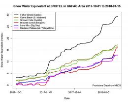
The mountains near Cooke City received 6 feet of snow equal to 6.2” of snow water equivalent (SWE) over the last week. This steady, heavy load combined with strong winds made large natural and human triggered avalanches likely the last couple days (video). Yesterday, skiers near Cooke City saw multiple recent avalanche crowns and saw one avalanche occur (photo). With minimal new snow and wind since yesterday, natural avalanches are not likely. The snowpack will adjust to the recent load relatively quick, but deserves a day or two to do so. Today, large wind slabs are easy to trigger and wind loaded slopes should be avoided. Be cautious of large cornices along ridgelines and pillows of snow below (photo). On non-wind loaded slopes, loose sluffs and slab avalanches of recent snow are possible. Avoid steep slopes if you see collapsing or cracks shooting across the snow surface. Avalanche danger today is CONSIDERABLE on all slopes.

The southern Madison and Gallatin ranges and mountains near West Yellowstone received a couple inches of snow each day of over the past week. Strong westerly winds drifted recent snow into slabs that are possible to trigger near ridgelines, below cornices, and on cross-loaded terrain features. Avoid fresh drifts and pillows of snow on steep slopes.
A second concern is a layer of weak surface hoar buried 1-2’ deep. Eric found this unstable layer in Taylor Fork on Wednesday (video, photo), and Doug and I found it near Hebgen Lake last Sunday (video). This layer is not widespread, but can break under the weight of a skier or rider. Snowmobilers in the southern Madison Range saw an avalanche yesterday that probably broke on this layer (photo), which is a clear sign of instability. Carefully assess the snowpack and practice cautious route finding if riding steep terrain. Today, avalanches are possible and avalanche danger is MODERATE on all slopes.
In the mountains near Bozeman and Big Sky wind loaded slopes and large cornices deserve extra caution. Eric went to the Throne in the northern Bridger Range yesterday and found a deep and generally stable snowpack on non-wind loaded slopes (video). Yesterday morning, a skier north of Bridger Bowl unintentionally triggered a large cornice that entrained recent snow and ran into flat terrain across a common skin track (photo, photo, photo). Minimal wind today makes fresh wind slabs unlikely. However, recent activity is a sign to avoid wind loaded slopes near ridgelines and below large cornices, and to stay far from the leeward edge when travelling along ridgelines (photo). Avalanche danger today is MODERATE on wind loaded slopes and LOW on all other slopes.
If you get out and have any avalanche or snowpack observations to share, drop a line via our website, email (mtavalanche@gmail.com), phone (406-587-6984), or Instagram (#gnfacobs).
White Heat Tracks Project seeks your input
The aim of the White Heat Project is to generate new and usable knowledge on risk-taking behavior, and on factors behind decision errors in avalanche terrain in particular. The White Heat Tracks project is an extension to the previous "SkiTracks" project, and is a collaboration between a group of researchers at UiT The Arctic University of Norway, in Tromsø; Montana State University, in Bozeman, USA; and Umeå University, in Umeå, Sweden. We are asking people to complete a decision-making survey: (https://montana.qualtrics.com/jfe/form/SV_74aRQuWMj0wbJHv) and if they have time and energy, also submit GPX tracks of their backcountry trips to "tracks@montana.edu
More information can be found here:
http://www.montana.edu/snowscience/tracks.html
And here: http://www.montana.edu/news/17430
Upcoming Avalanche Education and Events
BOZEMAN
Feb. 28th, Know Before You Go avalanche awareness, 7:00 p.m. @ Procrastinator Theater, MSU
March 2nd and 3rd, SheJumps Companion Rescue Clinic, Info and Register HERE
March 2nd, Avalanche Awareness, 6-7:00 p.m. Bozeman Split Fest
March 7th, Avalanche Awareness, 6-7:30 p.m. @ REI
DILLON
Feb. 24th and 25th, Snowmobile intro to avalanches w/ field course. More info: https://msuextension.org/conference/.
WEST YELLOWSTONE
TONIGHT!!!, Avalanche Awareness, 7-8 p.m. at West Yellowstone Holiday Inn Conference Center
COOKE CITY
Every Friday and Saturday, Current Conditions Update and Avalanche Rescue, Friday 6:30-7:30 p.m. at The Soda Butte Lodge in February. Saturday anytime between 10-2 @ Round Lake.
What are SWE talking about? In Dashboard Talk: Episode 6 Alex and Doug discuss snow water equivalent and why avalanche forecasters care about it.