Good Morning. This is Alex Marienthal with the Gallatin National Forest Avalanche Advisory issued on Sunday, February 11th at 7:00 a.m. Today’s advisory is sponsored by World Boards and Stronghold Fabrication. This advisory does not apply to operating ski areas.
Yesterday morning the mountains near Bozeman and Big Sky received a trace of snow as showers tapered into a cold, clear day throughout the advisory area. This morning, temperatures are in the single digits F and will reach high teens to low 20s F today. Strong north-northwest wind yesterday afternoon shifted overnight to westerly at 15-25 mph with gusts of 30-45 mph. West wind at 20-30 mph will continue this morning. Cloud cover will increase later today and snow showers tonight will bring 1-3” to the mountains by morning.

The mountains near Cooke City have a settled snow depth greater than 10 feet. Snowfall last week ended Friday and totaled 6” of snow water equivalent (SWE) over seven days. This steady, heavy load pushed weaknesses in the snowpack to a breaking point, and recent large natural avalanches were observed when skies cleared yesterday (photo, photo, photo). These slides broke 6-10’ deep on steep, rocky, wind loaded slopes. These deep slabs are difficult to trigger, but possible with high consequences. Be cautious of steep, wind-loaded slopes, which are identifiable by large overhanging cornices above.
Strong west-northwest wind overnight drifted snow into fresh wind slabs 1-3’ deep that are easy to trigger near ridgelines and along the cross-loaded edges of gullies and cliffs. On non-wind loaded slopes, avalanches within recent snow and dry loose sluffs are possible. Avalanche danger today is CONSIDERABLE on wind loaded slopes and MODERATE on all other slopes.

Yesterday, a snowmobiler triggered a large avalanche on Skyline Ridge near Cabin Creek and luckily escaped unharmed (photo). Strong northerly wind yesterday, and westerly wind overnight drifted recent snow into slabs near ridgelines and on cross-loaded terrain features. Avoid drifts and pillows of snow on steep, recently wind loaded slopes, and be cautious of large cornices along ridgelines.
A second concern in the southern Madison and Gallatin Ranges and Lionhead area near West Yellowstone is a weak layer of surface hoar buried 1-2’ deep (video, photo, video). Snowmobilers in the southern Madison Range saw an avalanche on Friday that probably broke on this layer (photo), a clear sign of instability. This layer is not widespread, so snowpack assessment can be tricky. Be cautious of open slopes sheltered from the wind, where this layer is likely preserved. Today, avalanches are possible and avalanche danger is MODERATE on all slopes.
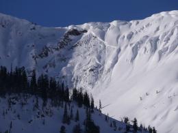
Near Bozeman and Big Sky, wind speeds increased yesterday afternoon and drifted recent snow into reactive soft slabs. A skier in Frazier Basin triggered a small slab that pushed them into rocky terrain and caused minor injury. Skiers in Middle Basin near Big Sky triggered an 8-10” deep slab at the top of a steep chute (photo). Friday morning, a skier north of Bridger Bowl unintentionally triggered a large cornice that entrained recent snow and ran into flat terrain across a common skin track (photo, photo, photo).
Today, avalanches are possible to trigger on wind loaded slopes and large cornices can easily break if you hit the right spot along the ridgeline above (photo). Avoid terrain above cliffs, dense trees and confined gullies to reduce the consequences of an avalanche, and travel far back from the leeward (corniced) edge along ridgelines (photo). On non-wind loaded slopes the snowpack is deep and generally stable as Eric found on Friday (video). Avalanche danger today is MODERATE on wind loaded slopes and LOW on all other slopes.
White Heat Tracks Project seeks your input
The aim of the White Heat Project is to generate new and usable knowledge on risk-taking behavior, and on factors behind decision errors in avalanche terrain in particular. The White Heat Tracks project is an extension to the previous "SkiTracks" project, and is a collaboration between a group of researchers at UiT The Arctic University of Norway, in Tromsø; Montana State University, in Bozeman, USA; and Umeå University, in Umeå, Sweden. We are asking people to complete a decision-making survey: (https://montana.qualtrics.com/jfe/form/SV_74aRQuWMj0wbJHv) and if they have time and energy, also submit GPX tracks of their backcountry trips to "tracks@montana.edu
More information can be found here:
http://www.montana.edu/snowscience/tracks.html
And here: http://www.montana.edu/news/17430
Upcoming Avalanche Education and Events
BOZEMAN
Feb. 28th, Know Before You Go avalanche awareness, 7:00 p.m. @ Procrastinator Theater, MSU
March 2nd and 3rd, SheJumps Companion Rescue Clinic, Info and Register HERE
March 2nd, Avalanche Awareness, 6-7:00 p.m. Bozeman Split Fest
March 7th, Avalanche Awareness, 6-7:30 p.m. @ REI
DILLON
Feb. 24th and 25th, Snowmobile intro to avalanches w/ field course. More info: https://msuextension.org/conference/.
COOKE CITY
Every Friday and Saturday, Current Conditions Update and Avalanche Rescue, Friday 6:30-7:30 p.m. at The Soda Butte Lodge in February. Saturday anytime between 10-2 @ Round Lake.
What are SWE talking about? In Dashboard Talk: Episode 6 Alex and Doug discuss snow water equivalent and why avalanche forecasters care about it.