Good Morning. This is Alex Marienthal with the Gallatin National Forest Avalanche Advisory issued on Monday, February 12th at 7:00 a.m. Today’s advisory is sponsored by Spark R&D and Bridger Bowl. This advisory does not apply to operating ski areas.
The mountains did not get any new snow since yesterday morning. Temperatures this morning are negative teens F in the Bridger Range and single digits above and below zero elsewhere. Wind has been east-southeast at 5-15 mph and 25-35 mph in the Bridger Range. Today, temperatures will reach single digits to high teens F. Wind will be easterly at 5-20 mph and shift to the north-northwest this evening. The southern mountains will get light snow showers today with 1-2” possible by tomorrow.

In the Bridger Range, strong easterly wind since yesterday afternoon drifted snow into slabs in un-common locations. These wind slabs are 1-2’ feet thick and found on the west side of ridgelines and along cross-loaded terrain at mid-elevations on all aspects. Slabs could be easy to trigger and even a small slide is harmful above cliffs or trees. Be extra cautious of steep, wind-loaded slopes today and minimize exposure to high consequence terrain. On non-wind loaded slopes the snowpack is generally stable (video). Fresh wind slabs in un-common locations today make avalanche danger CONSIDERABLE on wind loaded slopes and MODERATE elsewhere.

Near Cooke City and West Yellowstone, moderate east wind drifted recent snow into slabs 1-2’ thick that are possible to trigger along ridgelines and on mid-elevation cross-loaded terrain. On Saturday, a snowmobiler triggered a large wind slab on Skyline Ridge near Cabin Creek and luckily escaped unharmed (photo). Avoid drifts and pillows of snow on steep, recently wind loaded slopes, and be cautious of large cornices along ridgelines.
The previous couple days with light to moderate wind and no snow has given the snowpack near Cooke City time to adjust to last week’s heavy load (6” SWE in seven days). Large avalanches breaking 2-4’ deep within recent storm snow are less likely today, but possible. Yesterday, skiers saw a previous avalanche that appeared to have caught and buried a rider on Saturday (photo). Natural avalanches last week indicate the possibility of large avalanches on steep, wind-loaded slopes, identifiable by large overhanging cornices (photo, photo, photo). Evaluate snowpack and terrain carefully before riding steep slopes.
In the southern Madison and Gallatin Ranges and Lionhead area near West Yellowstone a weak layer of surface hoar buried 1-2’ deep can produce a large avalanche (video, photo, photo). This layer is not widespread, which can make snowpack assessment tricky. Be cautious of open slopes sheltered from the wind, where this layer is more likely preserved. Today, avalanches are possible and avalanche danger is MODERATE on all slopes.
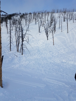
Near Big Sky and Hyalite the snowpack is generally stable underneath 1-2’ of snow that fell last week. I was in Beehive Basin yesterday and found a 4-6 foot deep, stable snowpack on most slopes. Cornices, fresh wind slabs and dry loose avalanches were the main concerns (photo). We identified and avoided higher consequence terrain and did quick stability tests before riding steep slopes (video). Moderate east wind last night drifted last week’s powder into small wind slabs that are possible to trigger near ridgelines. Be cautious of these slabs lurking in unusual locations due to the uncommon easterly wind direction. Today, fresh wind slabs and large cornices create a MODERATE avalanche danger on wind loaded slopes. Avalanche danger is LOW on non-wind loaded slopes.
If you get out and have any avalanche or snowpack observations to share, drop a line via our website, email (mtavalanche@gmail.com), phone (406-587-6984), or Instagram (#gnfacobs).
White Heat Tracks Project seeks your input
The aim of the White Heat Project is to generate new and usable knowledge on risk-taking behavior, and on factors behind decision errors in avalanche terrain in particular. The White Heat Tracks project is an extension to the previous "SkiTracks" project, and is a collaboration between a group of researchers at UiT The Arctic University of Norway, in Tromsø; Montana State University, in Bozeman, USA; and Umeå University, in Umeå, Sweden. We are asking people to complete a decision-making survey: (https://montana.qualtrics.com/jfe/form/SV_74aRQuWMj0wbJHv) and if they have time and energy, also submit GPX tracks of their backcountry trips to "tracks@montana.edu
More information can be found here:
http://www.montana.edu/snowscience/tracks.html
And here: http://www.montana.edu/news/17430
Upcoming Avalanche Education and Events
BOZEMAN
Feb. 28th, Know Before You Go avalanche awareness, 7:00 p.m. @ Procrastinator Theater, MSU
March 2nd and 3rd, SheJumps Companion Rescue Clinic, Info and Register HERE
March 2nd, Avalanche Awareness, 6-7:00 p.m. Bozeman Split Fest
March 7th, Avalanche Awareness, 6-7:30 p.m. @ REI
DILLON
Feb. 24th and 25th, Snowmobile intro to avalanches w/ field course. More info: https://msuextension.org/conference/.
COOKE CITY
Every Friday and Saturday, Current Conditions Update and Avalanche Rescue, Friday 6:30-7:30 p.m. at The Soda Butte Lodge in February. Saturday anytime between 10-2 @ Round Lake.
What are SWE talking about? In Dashboard Talk: Episode 6 Alex and Doug discuss snow water equivalent and why avalanche forecasters care about it.