Good Morning. This is Doug Chabot with the Gallatin National Forest Avalanche Advisory issued on Tuesday, February 13th at 7:15 a.m. Today’s advisory is sponsored by Montana Alpine Guides and Gallatin County Search and Rescue. This advisory does not apply to operating ski areas.
This is the 3rd morning in a row without new snow to report, the first time in 23 days to have such a drought! Under clear skies temperatures are in the single digits and winds are blowing W-SW at 20-35 mph in the north and 10-15 mph in the south. Today will be sunny and temperatures will rise into the 20s and drop into the teens tonight. No snow is expected until later Wednesday.

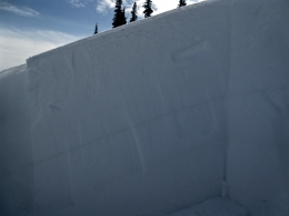
The northern mountains are windy at all elevations and mid-mountain winds may drift snow in gullies or terrain rollovers. Eric’s found deep and stable snow in the Bridger Range on Friday (video) and Alex also found good stability in Beehive Basin on Sunday (video). Overall the snowpack is strong. There are two minor avalanche concerns: isolated pockets of wind slabs along ridgelines and mid-elevations (all aspects), and large cornices breaking off if you get too close to the edge (photo). Given the lack of weak layers in the snowpack and minor wind-loading, the avalanche danger is rated LOW on all slopes.
The southern parts of the Madison and Gallatin Ranges along with the mountains around West Yellowstone have a layer of surface hoar (photo) buried 1-2’ deep that shows itself as a stripe in the snowpack (photo). Alex rode into Lionhead yesterday and dug on different aspects testing this layer. He concluded it is gaining strength and avalanches are becoming difficult to trigger. His video montage explains it all, reinforcing my opinion that if you only watched our videos, you’d have good grasp of what’s going on in the snowpack.
Both large and small avalanches were triggered in Teepee Basin and Skyline Ridge last Friday and Saturday when the danger was elevated (photo, photo). Today, triggering slides like these are unlikely, but not impossible and the avalanche danger is rated LOW.

The mountains around Cooke City are getting a respite from snowfall and wind-loading. Large and deep natural avalanches were spotted when the storm cleared on Saturday (photo) the same day a snowmobiler was buried near Sheep Creek (photo). He had 1 finger sticking out of the snow and his face was uncovered in 30 seconds by his partners (video). Give the heavy and steady load that these mountains received, I’m wary of giving slopes a full thumbs-up. Wind-loaded slopes near ridgelines are the main concern, and of course, deep slab avalanches breaking at the ground are unlikely, but not far from my mind. For today, the danger is rated MODERATE on all slopes since avalanches are still possible.
If you get out and have any avalanche or snowpack observations to share, drop a line via our website, email (mtavalanche@gmail.com), phone (406-587-6984), or Instagram (#gnfacobs).
Upcoming Avalanche Education and Events
BOZEMAN
Feb. 28th, Know Before You Go avalanche awareness, 7:00 p.m. @ Procrastinator Theater, MSU
March 2nd and 3rd, SheJumps Companion Rescue Clinic, Info and Register HERE
March 2nd, Avalanche Awareness, 7-8:00 p.m., MAP Brewing Bozeman Split Fest
March 7th, Avalanche Awareness, 6-7:30 p.m. @ REI
DILLON
Feb. 24th and 25th, Snowmobile intro to avalanches w/ field course. More info: https://msuextension.org/conference/.
COOKE CITY
Every Friday and Saturday, Current Conditions Update and Avalanche Rescue, Friday 6:30-7:30 p.m. at The Soda Butte Lodge in February. Saturday anytime between 10-2 @ Round Lake.
What are SWE talking about? In Dashboard Talk: Episode 6 Alex and Doug discuss snow water equivalent and why avalanche forecasters care about it.