Good Morning. This is Doug Chabot with the Gallatin National Forest Avalanche Advisory issued on Valentine’s Day, February 14th at 6:45 a.m. Today’s advisory is sponsored by our valentine sweeties, Marcie, Nina and Allyson. This advisory does not apply to operating ski areas.
The southern mountains got an inch of snow last night while other areas were missed. Temperatures are in the teens to low 20s with winds out of the southwest at 25-40 mph. Today will become cloudy, winds will decrease and a cold front will usher in snow later this afternoon. By morning 2-4” will blanket the mountains with another couple inches on Thursday.

Yesterday, Cooke City was windy and snow was blowing at the ridgelines and across faces loading slopes and drifting snow. Triggering a slide on these wind slabs is a concern. Cornices grew with the last storm and these monsters could break off, steamroll and injure you, or worse, trigger a deep and large avalanche that would be deadly (photo, photo). Furthermore, on Saturday, a snowmobiler was buried in an avalanche he triggered in Sheep Creek (video). Luckily he was uncovered quickly when his partners found his finger sticking out of the snow. Triggering slides like this is becoming less likely, but not impossible. For today, the avalanche danger is rated MODERATE on all slopes.

The northern mountains have been windy at all elevations and aspects for a few days creating drifts at ridgelines and in gullies. Instabilities associated with these drifts are isolated and small. One other concern associated with wind are cornices breaking underfoot since these thickened with the last storm and hide the ridge crest. The snowpack is generally strong and stable which is what Eric found in the Bridger Range on Friday (video) and Alex in Beehive on Sunday (video). Conditions have only improved since their visits. Avalanches are unlikely today, and the danger is rated LOW.
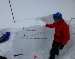
A weak layer of surface hoar can be found in the southern Madison and southern Gallatin Ranges and near West Yellowstone. These feathery crystals (photo) are buried up to 2 feet deep, are gaining strength, and becoming hard to trigger. Alex rode into the Lionhead area and could see it as a gray stripe in the snowpack (photo, video). This layer is mostly unreactive and avalanches are improbable, but it’s still our biggest worry. For today, the avalanche danger is rated LOW on all slopes.
Upcoming Avalanche Education and Events
BOZEMAN
Feb. 28th, Know Before You Go avalanche awareness, 7:00 p.m. @ Procrastinator Theater, MSU
March 2nd and 3rd, SheJumps Companion Rescue Clinic, Info and Register HERE
March 2nd, Avalanche Awareness, 7-8:00 p.m., MAP Brewing Bozeman Split Fest
March 7th, Avalanche Awareness, 6-7:30 p.m. @ REI
DILLON
Feb. 24th and 25th, Snowmobile intro to avalanches w/ field course. More info: https://msuextension.org/conference/.
COOKE CITY
Every Friday and Saturday, Current Conditions Update and Avalanche Rescue, Friday 6:30-7:30 p.m. at The Soda Butte Lodge in February. Saturday anytime between 10-2 @ Round Lake.
What are SWE talking about? In Dashboard Talk: Episode 6 Alex and Doug discuss snow water equivalent and why avalanche forecasters care about it.