Good Morning. This is Eric Knoff with the Gallatin National Forest Avalanche Advisory issued on, February 15th at 7:30 a.m. Today’s advisory is sponsored by Montana Alpine Guides and Yellowstone Club Community Foundation. This advisory does not apply to operating ski areas.
Overnight the mountains around Bozeman picked up 4-5” of new snow while the mountains around Big Sky, West Yellowstone and Cooke City picked up 6-8”. This morning snow has mostly exited the area and temps are in the single digits to low teens F under partly to mostly cloudy skies. Winds are blowing 15-25 mph out of the west with ridgetop gusts near Big Sky and Cooke City breaking 30 mph. Today, lingering snow showers could deposit an additional to 1-2”, mainly in the southern mountains. Skies become partly cloudy by this afternoon and no snow is expected tonight. Temps warm today into the teens to low 20’s F and moderate winds will continue out of the west.

Overall stability is improving around Cooke City, but new snow and wind will keep conditions spicy today, primarily on wind loaded slopes. Over the past 24 hours, consistent winds of 20-40 mph winds have impacted this area. Today, the primary concern is slides failing in the new snow. Wind drifts 1-2’ feet deep will be easy to trigger, mainly on wind loaded slopes near ridgelines or cross loaded sub-ridges. Slides failing on instabilities deeper in the pack are becoming less likely, but still remain a concern (photo, photo). Last Saturday, a snowmobiler was buried in an avalanche he triggered in Sheep Creek (video). Luckily he was uncovered quickly when his partners found his finger sticking out of the snow. Triggering slides like this is becoming less likely, but not impossible.
Today, human triggered avalanches are likely today on wind loaded slopes which have a CONSIDERABLE avalanche danger. Non-wind loaded slopes have a MODERATE avalanche danger.
Today’s combination of steady winds and fresh snow available for transport will result in sensitive, fresh wind drifts. This problem will be mostly confined to upper elevation slopes leeward to westerly winds. Watch for wind drifts and pillows near ridgelines and avoid slopes that appear to be freshly wind loaded. Slides will likely stay confined to the new snow, but do have the potential to step down to older wind drifts that formed prior to this storm. Loose snow avalanches involving the new snow are also possible on steeper slopes.
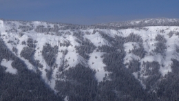
Outside of new snow instabilities, the snowpack is generally stable. Yesterday, we traveled to Mt Ellis and found a deep and strong snowpack. This is representative to what we’re seeing in the mountains around Bozeman and Big Sky (video, video).
Today, sensitive wind drifts make human triggered avalanches likely on wind loaded slopes which have a CONSIDERABLE avalanche danger. Non-wind loaded slopes have a MODERATE avalanche danger.
Yesterday, a fresh human triggered slide was observed up Cabin Creek in the southern Madison Range. Details and slim, but the slide was triggered by snowmobilers or snowbikers on a steep, wind loaded slope. It sounds like no one was injured in the event. The slide likely failed on a layer of surface hoar that has been found throughout the southern mountains. Today, 6-8” of new snow combined with moderate to strong winds out of the west will form fresh wind drifts and add stress to this buried weak layer.
Wind drifts will be sensitive to human triggers today. For this reason the avalanche danger is rated CONSIDERABLE on wind loaded slopes. The buried surface hoar layer does not have a widespread distribution, but does exist in isolated areas (photo, video). This makes human triggered slides possible on non-wind loaded slopes which have MODERATE avalanche danger.
If you get out and have any avalanche or snowpack observations to share, drop a line via our website, email (mtavalanche@gmail.com), phone (406-587-6984), or Instagram (#gnfacobs).
Upcoming Avalanche Education and Events
BOZEMAN
Feb. 28th, Know Before You Go avalanche awareness, 7:00 p.m. @ Procrastinator Theater, MSU
March 2nd and 3rd, SheJumps Companion Rescue Clinic, Info and Register HERE
March 2nd, Avalanche Awareness, 7-8:00 p.m., MAP Brewing Bozeman Split Fest
March 7th, Avalanche Awareness, 6-7:30 p.m. @ REI
DILLON
Feb. 24th and 25th, Snowmobile intro to avalanches w/ field course. More info: https://msuextension.org/conference/.
COOKE CITY
Every Friday and Saturday, Current Conditions Update and Avalanche Rescue, Friday 6:30-7:30 p.m. at The Soda Butte Lodge in February. Saturday anytime between 10-2 @ Round Lake.
What are SWE talking about? In Dashboard Talk: Episode 6 Alex and Doug discuss snow water equivalent and why avalanche forecasters care about it.