Good Morning. This is Eric Knoff with the Gallatin National Forest Avalanche Advisory issued on Friday, February 16th at 6:45 a.m. Today’s advisory is sponsored by Community Food Co-op and Cooke City Motorsports. This advisory does not apply to operating ski areas.
Over the past 24 hours, 1-3” of snow fell across the advisory area. This morning temps are in the single digits under partly cloudy skies and winds are blowing 15-35 mph out of the W-SW. Today, light snow will develop over the mountains and 1-3” is possible by this afternoon. A heavier shot of snow impacts the area tonight. The mountains will likely see an additional 2-4” by tomorrow morning. Winds will remain moderate to strong out the W-SW, but will shift to a more NW direction this evening. Temps will warm into the upper teens to mid-20’s under mostly cloudy skies.

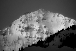
It seems that there’s always something happening in Cooke City, usually involving heavy snow, heavy wind or both. Yesterday, Doug rode north of town and found a foot of fresh snow sitting over a thin layer of facets (video). This layer formed during the three-day dry spell earlier in the week. This weak layer will be most reactive on wind loaded slopes. Watch for cracking and collapsing within the new snow, these are warning signs that unstable conditions exist. Be extra conservative on all steep slopes today (photo), especially those with wind drifted snow, and always be thinking about the consequences of a slide.
Today, fresh snow available transport combined with moderate to strong winds out of the west will make human triggered avalanches likely on wind loaded slopes, which have a CONSIDERABLE avalanche danger. On non-wind loaded slopes, human triggered avalanches are possible and the avalanche danger is rated MODERATE.
By yesterday afternoon, 6-10” of new snow accumulated in the mountains around Bozeman and Big Sky. The snow that fell was low density and easily transported by moderate winds out of the west. Yesterday, Alex and his partners found 10” of fresh snow on Divide Peak in Hyalite. The new snow was unreactive in stability tests on non-wind loaded slopes, but wind slabs near the ridgelines were a concern (video). Today, moderate to strong westerly winds will continue to load slopes in upper elevation leeward terrain. Fresh wind slabs near ridgelines and cross loaded sub-ridges will be sensitive to human triggers today. Dry loose avalanches (sluffs) will also be possible in steeper terrain today (photo).
Outside of new snow instabilities, the snowpack is generally stable (video).
Today, sensitive wind drifts make human triggered avalanches likely on wind loaded slopes which have a CONSIDERABLE avalanche danger. Non-wind loaded slopes have a MODERATE avalanche danger.
The main concern in the southern mountains is wind loaded slopes. Fresh snow combined with 20-30 mph westerly winds will form fresh drifts in upper elevation, leeward terrain. On Wednesday, a snowbiker up Cabin Creek triggered a large and dangerous slide on a heavily wind loaded slope (photo). Fortunately, nobody was injured in this event. Today, I would steer clear of wind loaded slopes, specifically those in steeper terrain.
A secondary problem is a layer of buried surface hoar. This layer is gaining strength and does not have a widespread distribution, but still holds the potential to produce avalanches (photo, video). Keep an eye out for this layer if you’re traveling on steep, sheltered slopes.
Continued snow and wind today will make human triggered avalanches likely on wind loaded slopes which have a CONSIDERABLE avalanche danger. Non-wind loaded slopes have MODERATE avalanche danger.
If you get out and have any avalanche or snowpack observations to share, drop a line via our website, email (mtavalanche@gmail.com), phone (406-587-6984), or Instagram (#gnfacobs).
Upcoming Avalanche Education and Events
BOZEMAN
Feb. 28th, Know Before You Go avalanche awareness, 7:00 p.m. @ Procrastinator Theater, MSU
March 2nd and 3rd, SheJumps Companion Rescue Clinic, Info and Register HERE
March 2nd, Avalanche Awareness, 7-8:00 p.m., MAP Brewing Bozeman Split Fest
March 7th, Avalanche Awareness, 6-7:30 p.m. @ REI
DILLON
Feb. 24th and 25th, Snowmobile intro to avalanches w/ field course. More info: https://msuextension.org/conference/.
COOKE CITY
Every Friday and Saturday, Current Conditions Update and Avalanche Rescue, Friday 6:30-7:30 p.m. at The Soda Butte Lodge in February. Saturday anytime between 10-2 @ Round Lake.
What are SWE talking about? In Dashboard Talk: Episode 6 Alex and Doug discuss snow water equivalent and why avalanche forecasters care about it.