Good Morning. This is Eric Knoff with the Gallatin National Forest Avalanche Advisory issued on Thursday, February 22nd at 7:00 a.m. Today’s advisory is sponsored by Gallatin Valley Snowmobile Association and Cooke City Super 8/Bearclaw. This advisory does not apply to operating ski areas.
Since yesterday morning the mountains south of Bozeman picked up 1-2” of new snow. At 5 a.m. temps are in the single digits above or below zero F under mostly cloudy skies. Winds are blowing 10-20 mph out of the W-SW. Today, highs will warm into the teens F and winds will remain light to moderate out of W-SW. There is a slight chance for snow showers in the mountains near West Yellowstone and Cooke City later today. Accumulations of 1-2” are possible in these areas by tomorrow morning.

Moderate to strong westerly winds have readily transported low density snow into thick wind slabs. Wind loaded slopes are most widespread in upper elevation terrain where winds have been the strongest. Watch out for large cornices, wind rolls or any visual evidence the slope is heavily wind loaded. Approach these slopes with caution or avoid them all together. Wind loaded slopes will be the most likely to produce avalanches today.
Slides failing on a thin layer of facets 1.5-2’ deep are also possible. On Tuesday, I found this layer on a south facing, non-wind loaded slope around 10,000 ft. This layer produced unstable results in stability tests (video). We did not find this layer to be reactive on north facing slopes, which indicates its distribution is sporadic. Look for and asses this thin layer of facets before committing to steeper terrain.
For today, wind-loading and buried weak layers make human triggered avalanches possible and the avalanche danger is rate MODERATE.
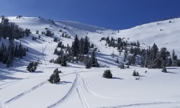
Dense wind slabs that formed over the past few days remain a concern. These thick, cohesive slabs rest over lower density snow, which is creating an unstable structure. On Tuesday, Doug found this to be the main avalanche problem in the Bridges (video). The Big Sky Ski Patrol also found this problem across Lone Mountain yesterday as did skiers up Mt Blackmore (photo). Winds have calmed slightly over the past 12 hours, which has given these slabs a little time to stabilize. Although wind load slopes won’t be quite a sensitive today, I would still treat them with respect, especially in steep high consequence terrain.
Large cornices are also a major concern (photo). These have grown huge over the past few weeks and remain under a tremendous amount of stress. On Monday, skiers up Hyalite unintentionally triggered a large cornice as they traversed along the ridge (photo). The cornice broke only a few feet from where they were standing and took out part of their skin track. This is a good reminder to give cornices a wide berth both on and below the ridgelines (illustration, photo).
Today, human triggered avalanches are possible on wind-loaded slopes which have a MODERATE avalanche danger. Non-wind loaded slopes have a LOW danger since the snowpack lacks widespread weak layers and is generally stable.
If you get out and have any avalanche or snowpack observations to share, drop a line via our website, email (mtavalanche@gmail.com), phone (406-587-6984), or Instagram (#gnfacobs).
Upcoming Avalanche Education and Events
BOZEMAN
Feb. 28th, Know Before You Go avalanche awareness, 7:00 p.m. @ Procrastinator Theater, MSU
March 2nd and 3rd, SheJumps Companion Rescue Clinic, Info and Register HERE
March 2nd, Avalanche Awareness, 7-8:00 p.m., MAP Brewing Bozeman Split Fest
March 7th, Avalanche Awareness, 6-7:30 p.m. @ REI
DILLON
Feb. 24th and 25th, Snowmobile intro to avalanches w/ field course. More info: https://msuextension.org/conference/
COOKE CITY
Every Friday and Saturday, Current Conditions Update and Avalanche Rescue, Friday 6:30-7:30 p.m. at The Soda Butte Lodge in February. Saturday anytime between 10-2 @ Round Lake.
A snowmobiler was caught and killed in an avalanche in Idaho, near the Wyoming border north of Alpine on Tuesday, February 20. This is the 3rd avalanche in SE Idaho since the beginning of the year. The East Idaho News has a preliminary report.