Good Morning. This is Eric Knoff with the Gallatin National Forest Avalanche Advisory issued on Thursday, March 1st at 7:00 a.m. Today’s advisory is sponsored by World Boards and Cooke City Motorsports. This advisory does not apply to operating ski areas.
At 5 a.m. there’s no new snow to report and temps range from the single digits to low teens F. Winds are blowing 15-30 mph out of the W-SW. Today, highs will warm into the teens to mid-20’s F and winds will remain moderate to strong out of the W-SW. Skies will become increasingly cloudy as the next storm system approaches. There is a slight chance for mountain snow showers this afternoon with a better chance this evening. By tomorrow morning the southern mountains will see 2-4” of new snow while the northern ranges will see 1-3”.

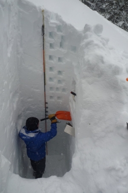
The snowpack across the advisory area is well over 100% (photo), which is creating deep and mostly stable conditions (photo). The one exception is wind loaded slopes (video). Over the past few days, strong winds have transported an abundance of low density snow into thick slabs (photo). These slabs mostly exist in wind loaded terrain near ridgelines and cross loaded sub-ridges.
Yesterday, we rode into the northern Bridgers and observed strong winds transporting snow. This was creating fresh slabs that were reactive in stability tests (video). We also checked out a large slide that occurred on Monday (photo). This slide appears to have been triggered by a falling cornice. Cornices are massive right now and pose a significant threat. Yesterday, skiers near Big Sky tried cutting a small chunk of cornice, but ended up triggering a much larger piece, which caught them by surprise. Make sure and give these monsters extra distance along the ridgelines and limit exposure time on slopes below.
Winds will remain moderate to strong today which will continue to build cornices and wind slabs. Recognize and avoid wind loaded slopes, especially in steep high consequence terrain.
Outside of wind loaded slopes there a few isolated instabilities to keep an eye out for. A thin layer of facets 2-3’ feet deep have produced unstable results in a few stability tests. On a positive note, this layer has not produced recent avalanches and has a very isolated distribution. While it’s not a major concern, it’s something to keep in mind.
Today, human triggered avalanches are possible on wind loaded slopes which have a MODERATE avalanche danger. Non-wind loaded slopes have a LOW avalanche danger.
If you get out and have any avalanche or snowpack observations to share, drop a line via our website, email (mtavalanche@gmail.com), phone (406-587-6984), or Instagram (#gnfacobs).
Upcoming Avalanche Education and Events
BOZEMAN
March 2nd, Avalanche Awareness, 7-8:00 p.m., MAP Brewing Bozeman Split Fest
March 2nd and 3rd, SheJumps Companion Rescue Clinic, Info and Register HERE
March 3rd, Pinhead Classic at Bridger Bowl. Ski race, awards and legendary after party. Info HERE.
March 7th, Avalanche Awareness, 6-7:30 p.m. @ REI
LIVINGSTON
March 20, Beer for a Cause Night at Katabatic Brewing, 4-8p.m. A dollar from every pint will be donated to The Friends of the Avalanche Center.
COOKE CITY
Every Friday and Saturday, Current Conditions Update and Avalanche Rescue, Friday 6:30-7:30 p.m. at The Soda Butte Lodge in February. Saturday anytime between 10-2 @ Round Lake.
In Dashboard Talks, Episode 7, Alex Marienthal and Doug Chabot provide a few thoughts about why you should read the daily advisory. As the season wears on, don't get "Advisory Fatigue." There is a lot of winter still to come!