Good Morning. This is Doug Chabot with the Gallatin National Forest Avalanche Advisory issued on Wednesday, March 14th at 6:30 a.m. Today’s advisory is sponsored by World Boards and Spark R&D. This advisory does not apply to operating ski areas.
At 5 a.m. under clear skies, temperatures are in the high 20s F with freezing line at 8-8500’. Winds are 10-20 mph and gusting to 45 mph out of the S-SW. Clouds are moving in this morning and temperatures will reach the 40s F with steady ridgetop winds. Later this afternoon a southwest flow will bring rain and snow and by morning I expect the mountains around Bozeman and Big Sky to have 1-2” of snow and 2-4” outside West Yellowstone and Cooke City. Colder temperatures and intermittent snow are forecasted through the weekend.

Even though mountain temperatures will be above freezing today, cloud cover and wind will keep the snow surface cool enough to inhibit wet avalanches. Rain, however, is a different beast. The fist rain on a winter snowpack can quickly create widespread avalanches, so get out of the mountains if it rains today. Only the most diehard would stay anyway, avalanches or not.
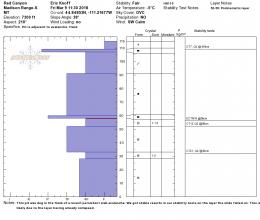
Yesterday there were reports of wet, loose avalanches in all our ranges except Cooke City (photo, photo). These will not be a danger today. Eric is in Cooke City and found good stability (video). His main concern is cornices breaking (photo, photo), which is also our #1 worry throughout the advisory area. Above freezing temperatures will make these large overhangs of snow structurally weak. A passing skier or sledder could trigger one and the danger is twofold: it can hurtle you off the ridge, and potentially trigger an avalanche on the slope below. Give all cornices a very wide berth.
The snowpack lacks widespread weak layers and is generally safe. It is still a good idea to dig and test the snow because avalanches can happen even during relatively stable times. A sledder last Wednesday triggered a slide on an isolated, steep slope near Hebgen Lake during a low danger (video), which illustrates this point. For today, both the wet and dry snow avalanche danger is rated LOW provided it does not rain, which would spike the danger quickly.
If you get out and have any avalanche or snowpack observations to share, drop a line via our website, email (mtavalanche@gmail.com), phone (406-587-6984), or Instagram (#gnfacobs).
Upcoming Avalanche Education and Events
LIVINGSTON
March 20, Beer for a Cause Night at Katabatic Brewing, 4-8p.m. A dollar from every pint will be donated to The Friends of the Avalanche Center.
Alex and Eric wrote up a one-page accident report on the avalanche that caught a snowmobiler on Kirkwood Ridge in the southern Madison Range on March 7th that is worth looking at: accident report, video.