Good Morning. This is Alex Marienthal with the Gallatin National Forest Avalanche Advisory issued on Monday, March 26th at 6:45 a.m. Today’s advisory is sponsored by Montana State Parks and the Community Food Co-op. This advisory does not apply to operating ski areas.
Since yesterday morning the mountains got 3-4” of snow in Hyalite, 1-3” near Big Sky, West Yellowstone and Cooke City, and a trace in the Bridger Range. This morning, temperatures are single digits to teens F and wind is north-northwest at 5-15 mph. Today will be mostly cloudy with a few shots of sun. Temperatures will reach high 20s F and wind will be northwest-west at 5-20 mph. Some areas will get scattered light snow showers today with little accumulation.

Today is another spring day with an array of avalanche problems to watch for. The primary concern is wind loaded slopes. Heavy new snow and strong wind on Saturday formed 8-12” deep slabs near ridgelines, along the base of cliffs and on steep convex terrain (video, video). A natural wind slab was observed yesterday on Saddle Peak (photo), and on Saturday skiers easily triggered 6-10” deep wind slabs in Beehive Basin (photo). Yesterday, the Big Sky ski patrol triggered a 3-5’ deep slab in a heavily wind loaded pocket (photo). Wind slabs have gained strength, but remain possible to trigger today. Wind loaded slopes should be approached with caution or avoided.
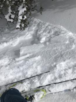
Loose snow avalanches are possible on slopes that have dry new snow on the surface this morning. Yesterday near Cooke City, skiers saw loose slides run naturally when the sun came out, and they triggered a 16” deep soft slab. Today, below freezing temperatures and mostly cloudy skies will hinder wet loose avalanche activity. However, any periods of sunshine will make loose avalanches possible to trigger or run naturally on steep, sunny slopes. Avoid steep slopes if the dry new snow becomes moist or wet (video), or if it slides easily on small test slopes (photo). Be aware of possible avalanche terrain overhead where natural loose slides can initiate, such as sunny rock outcrops or around cliffs (video).
Lastly, cornices are massive along ridgelines and can break under the weight of a person and farther back than expected (photo). Keep a far distance back from the leeward edge of ridgelines and avoid slopes directly below huge cornices.
Recent new snow and wind, and possible spring sunshine today make avalanches possible and avalanche danger is MODERATE. Aside from recent snow, wind slabs and large cornices, the snowpack is generally stable and deeper slides are not likely.
If you get out and have any avalanche or snowpack observations to share, drop a line via our website, email (mtavalanche@gmail.com), phone (406-587-6984), or Instagram (#gnfacobs).
Cornice Fall, Centennial Mountains, ID
On Tuesday, March 20, a snowmobiler walked to edge of the ridge and broke a cornice. He tumbled to the bottom and was injured and air evacuated out (photo). A report of the accident is HERE.
Send us your observations on Instagram! #gnfacobs
Posting your snowpack and avalanche observations on Instagram (#gnfacobs) is a great way to share information with us and everyone else this spring.