Good Morning. This is Doug Chabot with the Gallatin National Forest Avalanche Advisory issued on Tuesday, March 27th at 7:00 a.m. Today’s advisory is sponsored by Grizzly Outfitters in partnership with the Friends of the Avalanche Center. This advisory does not apply to operating ski areas.
Yesterday a trace to 1” of snow fell up Hyalite, but nowhere else. This morning skies are clear and temperatures are in teens with strong winds blowing 35-45 mph out of the west in the northern mountains and 10-25 mph elsewhere. Winds are blowing at all elevations, not just the ridgelines. Sunny skies this morning will become cloudy this afternoon as winds remain strong, but shift northwest. Snow will fall this evening and by morning the mountains will have 2-4” with the Bridger Range possibly getting double that.

Starting yesterday afternoon wind speeds in the northern mountains increased into the 30s and 40s and loaded slopes at all elevations (photo). Skiers in Frazier Basin saw avalanche debris from the weekend and wind slabs building in the afternoon. I expect a few natural avalanches on wind-loaded slopes this morning (photo). Cornices are also growing and will be extra touchy. Wind-loaded slopes, found along ridgelines, under cornices, and in low elevation gullies should be avoided since triggering slides is likely. On slopes sheltered from the wind the main avalanche concern will be sun warming the snow surface creating loose avalanches. Alex’s videos from Beehive Basin (Fri) and Buck Ridge (Sat) explain these concerns. For today the avalanche danger is rated CONSIDERABLE on all wind-loaded terrain and MODERATE elsewhere.

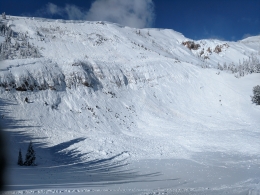
The southern mountains are less windy than its northern neighbors with west winds blowing 10-25 mph. Wind-loaded slopes, along with touchy cornices, are the main avalanche concern. A snowmobiler saw a large avalanche triggered by a cornice fall near West Yellowstone on Lionhead ridge that broke late Saturday (photo). Yesterday, south of Cooke City, a skier saw a natural avalanche on a wind-loaded slope in Republic Creek (photo). Both are evidence that triggering wind-loaded slopes are possible today given the recent snow and wind. Eric rode into Teepee Basin on Saturday, got stuck, and nonchalantly made a video outlining these avalanche concerns, which remain today. Approach wind-loaded slopes cautiously and be extra careful of cornices, both triggering them from the ridgelines and also playing on slopes underneath. Slopes without a wind-load are generally safe, but given the rapidly changing spring conditions, a shot of sun warming the snow surface could create loose snow avalanches. On Sunday, skiers near Cooke City triggered a 16” deep soft slab avalanche which remains possible on other slopes. For today, the avalanche danger is rated MODERATE on all slopes.
If you get out and have any avalanche or snowpack observations to share, drop a line via our website, email (mtavalanche@gmail.com), phone (406-587-6984), or Instagram (#gnfacobs).
Send us your observations on Instagram! #gnfacobs
Posting your snowpack and avalanche observations on Instagram (#gnfacobs) is a great way to share information with us and everyone else this spring.