Good Morning. This is Doug Chabot with the Gallatin National Forest Avalanche Advisory issued on Wednesday, March 28th at 6:45 a.m. Today’s advisory is sponsored by Yellowstone Arctic Yamaha and Yamaha Motor Corp in partnership with the Friends of the Avalanche Center. This advisory does not apply to operating ski areas.
At 5 a.m. most mountain locations have 4-5” of new snow and closer to 8” up Hyalite while valleys have rain. Mountain temperatures are in the upper teens to low 20s and winds are W-NW at 15-25 mph with gusts of 40 mph. Snowfall will continue on a northwest flow and drop another 1-2” before ending later this morning. Wind will decrease through the day and skies will become partly cloudy.

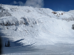
The Bridger Range has 4” of snow and stronger wind than elsewhere. Gusts of 70 mph were recorded at Bridger Bowl yesterday and there were many avalanches on wind-loaded slopes, both naturally occurring (photo) and also easily triggered from the ridgelines by the ski patrol. The wind slabs were 1.5’ thick and ran far distances. Eric went into the northern Bridger Range near Fairy Lake and had to notch back his plans when he was confronted with natural avalanches, shooting cracks under his feet, strong winds and active loading (video).
Alex took a big tour in Hyalite yesterday and noted isolated wind slabs were breaking near the ridgelines and some higher elevation gullies. Cornices also recently broke with the wind-loading (photo1, photo2) and pose a serious threat. He reported at least 4” of new snow by late afternoon and SNOTEL shows another 4-5” (.4-.5” snow water equivalent) last night, including similar amounts in Big Sky, to West Yellowstone, and Cooke City. Winds are moderate with strong gusts (40 mph) and I expect wind-loaded slopes could be easily triggered in all our ranges today. Recent avalanches outside Cooke City (photo) and Lionhead (photo) illustrate this instability. On slopes without a wind-load the main concern is checking to see if the new snow is sticking to the older snow. A quick stability test in the upper couple feet is a good idea since avalanches are more likely during and immediately after a storm.
As Eric said in his video, “If you avoid wind-loaded slopes you’ll avoid avalanches.” This is true again today. New snow this morning and continued wind is creating unstable conditions and a CONSIDERABLE avalanche danger on all wind loaded slopes. Slopes without a wind-load have a MODERATE danger.
WET AVALANCHES
If the sun comes out today the new snow will wet and avalanche. Most slides will be loose avalanches; not very large, but numerous. Snow conditions and stability change quickly in the spring. Pinwheels and sluffing of the surface snow are classic signs the wet avalanche danger is increasing.
If you get out and have any avalanche or snowpack observations to share, drop a line via our website, email (mtavalanche@gmail.com), phone (406-587-6984), or Instagram (#gnfacobs).
Send us your observations on Instagram! #gnfacobs
Posting your snowpack and avalanche observations on Instagram (#gnfacobs) is a great way to share information with us and everyone else this spring.