Good Morning. This is Doug Chabot with early season avalanche and weather information for the Gallatin National Forest Avalanche Center on Monday, November 11th. This bulletin is sponsored by The Friends of the Avalanche Center and World Boards and will be updated as conditions change.
In the last 24 hours the Bridger Range picked up 5” of snow while the mountains south of Bozeman to Big Sky and Taylor Fork got 1-2” and only a trace around West Yellowstone and Cooke City. Under clear skies mountain temperatures dropped to the single digits to zero F and westerly winds are blowing light at 5-15 mph. This week a dry high-pressure ridge will bring sunny skies, increasing winds and daytime temperatures reaching into the 30s. Our next chance of snow is Friday.

It has snowed somewhere in our forecast area 13 out if the last 14 days (weather log). The mountains around Bozeman and Cooke City have 3-4’ of snow on the ground with 2-4’ measured around Big Sky and West Yellowstone. The snowpack has a good structure: it is dense near the ground and supports our weight and lacks widespread weak layers. This is a positively refreshing start to the season!
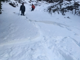
Wind-loading is our #1 avalanche concern. On Friday and again on Sunday, ice climbers triggered small avalanches on a wind-loaded slopes up Hyalite (details, photo, photo) and on Saturday a snowboarder released a wind-slab in Middle Basin north of Big Sky (photo, details). Westerly winds are forecasted to pick up today and remain strong until mid-week, blowing powder into wind-drifts that could be easily triggered. A common warning sign on wind-loaded slopes are cracks shooting out in front of your skis.
It is early season and we are still formulating an overall picture of the snowpack. Our photos page and snowpit profiles detail the information we are gathering and are worth a quick study. In general we are conservative in our snowpack assessments this time of year. Last Tuesday a large avalanche was triggered by the Big Sky Ski Patrol (details), and skiers found weak snow (facets) in Hyalite and Cooke City. It’s important to dig and test the snow to rule out potential dangers. Once we get more information and more snowfall we will start issuing daily advisories and danger ratings.
New this season, we added hyperlinks to the Weather and Avalanche Log and a new Menu item <Avalanches and SnowPits> with information on avalanche activity and incidents.
We are preparing for winter, scheduling avalanche classes, and setting up weather stations. If you get outside send us an observation via our website, email (mtavalanche@gmail.com), phone (406-587-6984), or Instagram (#gnfacobs).
Upcoming Avalanche Education and Events
Our education calendar is full of awareness lectures and field courses. Check it out: Events and Education Calendar.
November 14, 1-hr Avalanche Awareness, 6-7pm at Spire Climbing Center
November 14, 1-hr Avalanche Awareness, 6-7pm at Round House Sports
November 26, MSU Snow and Avalanche Workshop, 5-9pm at MSU SUB Ballroom A
November 29, 30 and Dec 1, 2or 8, Intro to Avalanche w/ Field Day, more info here
Every Friday and Saturday in Cooke City starting November 23 and 24, Free Rescue training and Snowpack update, exact locations TBD
Practice with your rescue gear, and test your partner’s skills. Put fresh batteries in your beacon and check your shovel and probe for any damage, and replace them if needed.