Good Morning. This is Alex Marienthal with pre-season avalanche and weather information for the Gallatin National Forest Avalanche Center on Saturday, November 10th. This bulletin is sponsored by The Friends of the Avalanche Center and Gallatin County Search and Rescue.
At 4am the mountains have 1-2” of new snow in most areas with 3” near Cooke City. Yesterday, wind speed increased to 15-25 mph out of the west-southwest with gusts overnight of 40-55 mph. Temperatures are teens F this morning and will be teens to low 20s F today and tomorrow, then warm to the mid-30s early next week. Snow showers today and tomorrow will drop 4-6” in the mountains with 8-10” possible near Cooke City by the end of the weekend.

In the Bridger Range, Hyalite, and near Cooke City there is 3-4’ of settled snow on the ground equal to 4-6” of snow water equivalent (SWE). The mountains near Big Sky and West Yellowstone have 2-4’ of snow equal to 2-4” of SWE. Warm and heavy snowfall over the last couple weeks built a relatively dense and right-side-up snowpack. Instabilities during the storms were mostly confined to the upper layers of new and drifted snow (recent avalanche activity), and these should gain strength quickly.
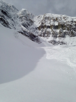
Wind was light to moderate at the end of the storm on Wednesday, and it left plenty of snow for strong wind yesterday to drift into fresh slabs. Yesterday, ice climbers in Hyalite triggered a small slab on their descent (details, photo). This is a clear sign that fresh drifts are unstable, and a reminder to be extra cautious in steep gullies where even a small slab could take you for a deadly ride. Avoid steep, wind loaded slopes if you see blowing and drifting snow or cracking of fresh drifts.
Skiers in the Bridger Range, Hyalite, Cooke City and Beehive have reported a mostly stable snowpack with the recent large storm snow bonding generally well to the old snow at the ground. This is similar to what Doug and I found earlier this week in the Bridgers (video, photo). However, a skier in Hyalite and a skier in Cooke City found sugary facets below a hard crust in the bottom foot of their snowpits (photo, photo), and the skier in Cooke had unstable stability test results. These observations and the large avalanche that Big Sky triggered earlier this week (details) are clues to pay attention to this layer, and dig to see if it exists where you are riding. You can suspect this layer exists on high elevation and shady slopes (facing northerly), but it can’t be ruled out unless you dig to the ground.
We are preparing for winter, scheduling avalanche classes, and setting up weather stations. If you get outside send us an observation via our website, email (mtavalanche@gmail.com), phone (406-587-6984), or Instagram (#gnfacobs).
Upcoming Avalanche Education and Events
Our education calendar is full of awareness lectures and field courses. Check it out: Events and Education Calendar.
November 14, 1-hr Avalanche Awareness, 6-7pm at Spire Climbing Center
November 14, 1-hr Avalanche Awareness, 6-7pm at Round House Sports
November 26, MSU Snow and Avalanche Workshop, 5-9pm at MSU SUB Ballroom A
November 29, 30 and Dec 1, 2or 8, Intro to Avalanche w/ Field Day, more info here
Every Friday and Saturday in Cooke City starting November 23 and 24, Free Rescue training and Snowpack update, exact locations TBD
Practice with your rescue gear, and test your partner’s skills. Put fresh batteries in your beacon and check your shovel and probe for any damage, and replace them if needed.