Good Morning. This is Alex Marienthal with the Gallatin National Forest Avalanche Forecast issued on Sunday, December 16th at 7:00 a.m. Today’s forecast is sponsored by Beartooth Powder Guides and Werner Wealth Management. This forecast does not apply to operating ski areas.
This morning the mountains have no new snow, temperatures are in the 20s F, and wind is out of the southwest at 15-25 mph with gusts to 40 mph. Today will be mostly sunny with temperatures in the low 30s F and wind out of the south-southwest at 15-25 mph. Cloud cover will increase this evening and there is a chance for snow tomorrow afternoon.

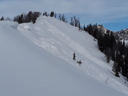
Strong winds yesterday morning literally blew the roof off a structure at Big Sky and delayed lifts from opening at Bridger Bowl. Gusts were 50 to 60 mph and reached 89 mph on the summit of Lone Mountain. These strong winds drifted snow into thick, unstable hard slabs throughout the advisory area. Earlier this week we found weak layers buried 6-8” deep in the Bridger Range (video) and in the Taylor Fork (video). On non-wind loaded slopes these layers have not been reactive, but wind loaded slopes have thick unstable slabs over these weak layers. Yesterday we observed and received reports of unstable drifts of snow throughout the advisory area:
- In the Bridger Range, Eric and I found these hard slabs 12-18” thick, resting on weak surface hoar and facets that formed during high pressure in early December (video). One of these thick drifts collapsed with an audible “whumph” and shot cracks 30’ wide (photo, details).
- Skiers in Cooke City, Hyalite, the southern Gallatin, and the Madison Range triggered collapses on wind loaded slopes, saw natural wind slabs (details), and avoided travel on steep, drifted slopes.
- A snowbiker near Cooke City triggered a thick drift on a road cut (photo, details).
- A natural avalanche near Ernie Miller ridge broke on weak snow at the base of the snowpack and propagated 500’ wide (photo).
Today, avalanches are possible to trigger on wind loaded slopes which have MODERATE avalanche danger. Avalanche danger is LOW on non-wind loaded slopes.
The Lionhead area near West Yellowstone has the weakest and shallowest snowpack in the advisory area. This area also received strong wind yesterday that drifted snow into thick hard slabs over weak, sugary snow. The foundation of the snowpack is a persistent weak layer of sugary facets (video, photo), and could produce large avalanches on wind loaded slopes. Human triggered avalanches are possible today and wind loaded slopes have a MODERATE avalanche danger. Avalanche danger is LOW on non-wind loaded slopes.
If you get out and have any avalanche or snowpack observations to share, contact us via our website, email (mtavalanche@gmail.com), phone (406-587-6984), or Instagram (#gnfacobs).
Upcoming Avalanche Education and Events
Our education calendar is full of awareness lectures and field courses. Check it out: Events and Education Calendar.
COOKE CITY
Every Friday and Saturday, Rescue Training and Snowpack Update. Friday 6:30-7:30 p.m. at the Soda Butte Lodge. Saturday anytime between 10-2 @ Round Lake.
Check out our new “Avalanches and Snowpits” menu item where we list all the reported avalanche activity.