Good morning. This is Doug Chabot with the Gallatin National Forest Avalanche Forecast issued on Wednesday, January 23rd at 7:00 a.m. Today’s forecast is sponsored by Grizzly Outfitters in partnership with the Friends of the Avalanche Center. This forecast does not apply to operating ski areas.
At 5 a.m. it is snowing and 5” have fallen in the Bridger Range and 3”-5” everywhere else. Snowfall will continue today with an additional 8-12” by morning, maybe more outside Cooke City. Winds are blowing west to south at 20-30 mph with gusts of 48 mph in the north and half that in the southern mountains. Today will remain windy with temperatures in the teens and snowfall will end this evening. If you are unable to call in sick this morning, (cough), you should probably do so tomorrow.

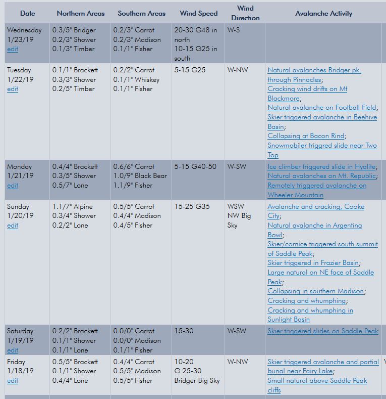
All Regions
Since Friday morning our entire forecast area has received 1.5-2 feet of snowfall (near 2.5” of SWE in places). The most accurate measure of instability is avalanche activity and red flags such as collapsing or cracking. Since Friday this list of instability is long and growing with 20 events noted (14 in the northern ranges, 6 in the southern ranges). Check out the Weather and Avalanche Log for a synopsis of snowfall and avalanche activity.
Two avalanches are especially noteworthy:
- From afar, skiers triggered an avalanche on Wheeler Mountain on Monday (details). I expect similar instability anywhere there is shallow, faceted snow: Mt. Ellis, Beehive Basin, Bacon Rind, Hebgen Lake and Cooke City to name a few.
- Ice climbers triggered a small slide on a popular climb up Hyalite on Monday (details). Although small, it was extremely dangerous because of the serious terrain. Small avalanches above terrain traps are bad news no matter if you are climbing, skiing or riding.
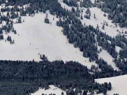
Shallow snowpacks are weak and unstable. Yesterday, Eric found this to be true in Teepee Basin in the southern Madison Range (video) and also on a road cut on Hwy 191 (photo). It remains true in the northern Gallatin Range where skiers triggered a 2-foot deep slide on Mt. Wheeler from hundreds of feet away. Having just come back from Cooke City I know it to be true there as well (video). If you sink to ground after stepping off your skis or sled, you can be assured that you found the facets.
Many avalanches are confined to new snow, especially if it has been drifted into wind slabs. This new snow instability is prevalent throughout our advisory area which Alex and Ian found in the Bridger Range on Sunday (video). Natural and human triggered avalanches along the Bridger Ridge (every day since Friday), in Hyalite (Monday), in Beehive Basin (yesterday), near West Yellowstone (yesterday) and Cooke City (Monday).
Your homework for today is to remember three points:
1. The avalanche danger will rise as the snow continues to fall.
2. Shallow snowpacks consisting of weak facets should be avoided.
3. New snow will continue to avalanche on steep slopes, especially if it has been drifted by the wind.
For today, the avalanche danger is rated CONSIDERABLE on all slopes and avalanche terrain should be avoided. Collapsing, cracking and recent avalanches are signs of instability and we’ve had all three in the last 24 hours. There will be more today.
If you get out and have any avalanche or snowpack observations to share, contact us via our website, email (mtavalanche@gmail.com), phone (406-587-6984), or Instagram (#gnfacobs).
Skier killed in avalanche in Colorado
On Monday, a backcountry skier was buried and killed in an avalanche near Aspen, Colorado. Information from the Colorado Avalanche Information Center is HERE.
Skier killed in avalanche in Utah
On Friday, a skier was buried and killed in an avalanche in Utah. He and his partner were not wearing avalanche transceivers. Details from the Utah Avalanche Center are HERE.
Upcoming Avalanche Education and Events
Our education calendar is full of awareness lectures and field courses. Check it out: Events and Education Calendar.
BOZEMAN
TONIGHT! January 23, 24 and 26, Advanced Avalanche Workshop w/ Field Day, Info and Register Here.
February 2, King and Queen of the Ridge at Bridger Bowl (fundraiser). Register with Bridger to hike in the event, and create a pledge page to raise funds with your Ridge laps.
WEST YELLOWSTONE
January 26, 1-hr Avalanche Awareness for Snowmobilers, 7-8 p.m. Holiday Inn West Yellowstone.
COOKE CITY
Every Friday and Saturday, Rescue Training and Snowpack Update. Friday 6:30-7:30 p.m. at the Soda Butte Lodge. Saturday anytime between 10-2 @ Round Lake.
The government shutdown and its effects on USFS avalanche centers is highlighted in this article in Powder Magazine.