Good morning. This is Eric Knoff with the Gallatin National Forest Avalanche Forecast issued on Friday, February 22nd at 7:00 a.m. Today’s forecast is sponsored by Grizzly Outfitters in partnership with the Friends of the Avalanche Center. This forecast does not apply to operating ski areas.
This morning there’s no new snow to report. At 5 a.m. temps range from the single digits above or below zero F and winds are blowing 5-15 mph out of the west-northwest. Today, highs warm into the teens F under partly cloudy skies and winds will remain light to moderate out of the west-northwest. No snow is expected over the next 24 hours.

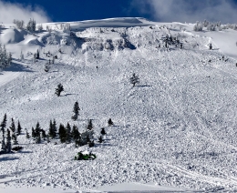
Minimal snow and wind in the southern mountains has allowed the snowpack time to adjust and become more stable. Although avalanches are becoming harder to trigger, they remain a very real concern. If a slide is triggered, it will likely fail on weak layers buried deep in the pack. A large slide triggered in the Lionhead area on Monday is a scary reminder of what remains possible (video, details and photos). Heavily wind loaded slopes are the most prone to producing deep slab avalanches, but non-wind loaded slopes remain suspect.
Be extra cautious when skiing or riding in steep rocky terrain or near scoured ridgelines where slab margins are thinner. These are likely areas to impact weak layers that could propagate into deeper parts of the slope. Assessing stability on deep weak layers is difficult and avoidance is really the best strategy for dealing with them. Remember that tracks on a slope don’t mean it’s stable, particularly with deep instabilities.
Today, large human triggered avalanches are possible and the avalanche danger is rated MODERATE.
Wind loaded slopes are the main concern in the mountains around Bozeman, Big Sky and Cooke City. Yesterday, a skier near Big Sky triggered a small wind slab in a steep alpine chute that subsequently triggered a larger slab as it traveled downhill. Fortunately, the skier was above the slide and not caught. On Monday, a skier triggered a larger slide on a heavily wind loaded slope outside of Cooke City. The skier deployed his airbag and fortunately escaped unharmed (photo, details).
Slides breaking 1-2’ deep in wind-blown are most likely, but there is the potential for slides to step down to weak layers buried deep in the pack. Activity on Buck Ridge and around Cooke City earlier in the week are good examples of this problem (photo, photo, video). Outside of wind loaded slopes the snowpack is generally stable. Yesterday, I skied around the Throne in the northern Bridgers. I found the new snow to be unreactive and well bonded to the old snow surface in non-wind loaded terrain (video).
Today, the avalanche danger is rated MODERATE on wind loaded slopes and LOW on all other slopes.
Upcoming Avalanche Education and Events
Our education calendar is full of awareness lectures and field courses. Check it out: Events and Education Calendar.
BOZEMAN
February 22 and 23, Women’s Companion Rescue Clinic, 6-8 p.m. Friday at REI, 10-4 Saturday in the field. More Info and Register.
March 1, 2 and 3, Bozeman Split Fest, More info at www.bozemansplitfest.com.
WEST YELLOWSTONE
February 23, 1-hr Avalanche Awareness for Snowmobilers, 7-8 p.m. Holiday Inn West Yellowstone.
COOKE CITY
Every Friday and Saturday, Rescue Training and Snowpack Update. Friday 6:30-7:30 p.m. at the Soda Butte Lodge. Saturday anytime between 10-2 @ Round Lake.
On Tuesday, a backcountry skier ascending a trail near Telluride, Colorado was buried and killed by an avalanche triggered by a rider descending above him. Preliminary details and photographs here.