Good Morning. This is Doug Chabot with the Gallatin National Forest Avalanche Forecast on Thursday, December 26th at 7:00 a.m. Today’s forecast is sponsored by Your Montana Chevy Dealers and Mystery Ranch. This forecast does not apply to operating ski areas.
In the last 24 hours 1-2 inches has fallen in the northern mountains. This morning lingering showers will give way to clearing skies. Temperatures are in the high single digits to low teens and wind is gentle at 5-10 mph, mostly from the southwest. Temperatures will remain cool and wind light. More snow is expected late Friday that will continue through the weekend.

The Lionhead area near West Yellowstone has dangerous avalanche conditions. On Tuesday close to a foot of new snow fell onto a weak snowpack. It was the largest snowfall of the season and measured .8-1” of snow water equivalent. This snow came in with strong southwest wind and drifted at the ridgelines. A thick, sugary layer of weak snow at the ground will struggle to support the weight of the new snow, which Alex shows in this video and photo. Triggering avalanches with a snowmobile or skis is likely, even from a distance. This weak layer is widespread and connects many slopes allowing an avalanche to propagate far and wide. Stay clear of runout zones (the bottom of slopes). Today is a day to play in the flats, far away from the edges of steep slopes. For today, the avalanche danger is rated CONSIDERABLE on all slopes.

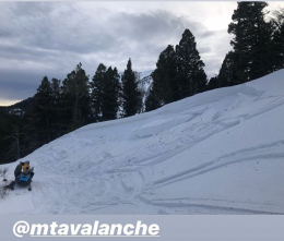
Since Tuesday, the mountains surrounding Big Sky, south to Taylor Fork and Cooke City received 5-7” that drifted at the ridgelines. Yesterday, these wind-drifts avalanched with ski cuts and the same possibility remains today. Furthermore, a weak layer buried 1-2 feet under the surface holds the potential to avalanche. We have gotten reports from the Big Sky area, Bacon Rind and Cooke City that point to a strengthening snowpack; however, this thin layer of weak facets should not be forgotten. Although the likelihood of triggering slides is decreasing we still advocate testing the snowpack before giving a slope a thumbs up. Our videos in Taylor Fork, Beehive and Cooke City are instructive. Go ahead, binge watch a few. Not only will you make better decisions, you’ll sound smart to your friends. For today, given the need to evaluate the snowpack and a possibility of triggering slides, the avalanche danger is rated MODERATE.

Since Tuesday, 2-3” of low density snow fell in the mountains around Bozeman. This was not enough to increase the avalanche danger. Overall the mountains have a stable snowpack and safe avalanche conditions. A minor exception to this are small, isolated wind drifts at the ridgeline which could be triggered. On Tuesday I went into the northern Bridger Range and found 3 feet of stable snow in my snowpit, although we had to navigate an very thin snowpack to get there (video, photo). For today, the avalanche danger is rated LOW.
If you get out, please send us your observations no matter how brief. You can fill out an observation form, email us (mtavalanche@gmail.com), leave a VM at 406-587-6984, or Instagram (#gnfacobs).
Upcoming Avalanche Education and Events
Our education calendar is full of awareness lectures and field courses. Check it out and plan to attend one or two: Events and Education Calendar.
COOKE CITY
Every Friday and Saturday, Snowpack Update and Rescue Training. Friday, 6:30-7:30 p.m. at the Soda Butte Lodge. Saturday anytime between 10-2 @ Round Lake.
WEST YELLOWSTONE
January 4, 1-hr Avalanche Awareness, 7-8 p.m. at West Yellowstone Holiday Inn.
BOZEMAN
January 15 and 16, Introduction to Avalanche w/ Field Course, evenings of January 15 & 16 plus one field day either January 18, 19 or 25. Snowmobile specific field day offered January 25. More info and Register Here.
Accident reports from the recent fatalities in Colorado and Utah are worth reading to learn from. Check them out here: Utah Report, Colorado Report.