Good Morning. This is Alex Marienthal with the Gallatin National Forest Avalanche Forecast on Sunday, January 12th at 7:15 a.m. Today’s forecast is sponsored by Spark R&D and Mystery Ranch. This forecast does not apply to operating ski areas.
Since yesterday morning the mountains near Bozeman got 1-2” of snow. Elsewhere got 3-4” with the Yellowstone Club showing 7” of low density snow. Wind has been west-southwest at 10-20 mph with gusts to 30 mph. This morning temperatures are single digits to teens F. Today temperatures will be low teens to mid-20s F with southwest wind at 15-30 mph. Expect light snow today with increased snowfall intensity overnight. By morning 4-6” of new snow is possible near Bozeman and 6-10” near Big Sky, West Yellowstone and Cooke City.

Since the New Year the mountains near Cooke City received the most snow in our advisory area (43” of snow equal to 4.3” of snow water equivalent) which creates dangerous avalanche conditions. A skier or rider can easily trigger an avalanche on wind loaded slopes where moderate wind has drifted the new snow into fresh slabs. On Friday a snowmobiler triggered an avalanche near Daisy Pass and a recent natural avalanche was seen on the ridge of Miller (photo, photo). These thick slabs can be deadly, and plus-sized avalanches are possible if they break on persistent weak layers deeper in the snowpack. Avoid steep wind loaded slopes and carefully evaluate snowpack and terrain before crossing on or underneath any steep slope. Avalanche danger is CONSIDERABLE on wind loaded slopes and MODERATE on non-wind loaded slopes.

In the Bridger Range and mountains from Big Sky to West Yellowstone it is possible to trigger an avalanche on weak, sugary snow near the ground. On Friday, Dave found this unstable snowpack structure on the Throne in the northern Bridger Range (video), and last week skiers in Truman Gulch on the west side of the Bridgers found a similarly unstable snowpack (snowpit). We have consistently found a poor snowpack structure at Buck Ridge, Beehive, Taylor Fork and near West Yellowstone (videos). Last week large avalanches broke deep in the snowpack on these weak layers near Big Sky (photo, video). Recent snowfall has been light and not overloaded the snowpack, but weak layers remain under stress and just need the weight of a human to trigger a large avalanche (video,photo). Addittionally, fresh drifts are possible to trigger and can break deeper and wider on buried weak layers. These fresh drifts are thicker and more likely where recent snowfall was deeper, like near Big Sky and the Bridger Range.
Large avalanche are becoming more difficult to trigger, but their consequences remain deadly. Be careful with terrain choices and snowpack evaluation before riding steep slopes. Avalanche danger is MODERATE.
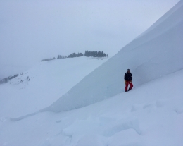
The northern Gallatin Range received 12-15” of snow over the last week which fell on a generally stable snowpack. This area received minimal snow over the last month, and we have not received reports of avalanches or collapsing on deeper persistent weak layers. Yesterday I toured to Mt. Blackmore in Hyalite and our main avalanche concern was fresh drifts of snow (video). We saw debris from a couple small wind slabs. Otherwise, we did not see signs of instability and got no unstable test results in multiple snowpits. Avalanches are possible to trigger on wind loaded slopes where danger is MODERATE. Avalanche danger is LOW on non-wind loaded slopes.
If you get out, please send us your observations no matter how brief. You can fill out an observation form, email us (mtavalanche@gmail.com), leave a VM at 406-587-6984, or Instagram (#gnfacobs).
Webpage dedicated to the Centennial Range in Idaho and Montana
After the two snowmobiler avalanche fatalities on Reas Peak in the Centennial Range in January 2018 we created a webpage so riders could get good, relevant information regarding snowpack and avalanches. Although the Centennial Range is not part of the Gallatin National Forest Avalanche Center's forecast area, we are the closest avalanche center and have valuable information to share. More…
Upcoming Avalanche Education and Events
Our education calendar is full of awareness lectures and field courses. Check it out and plan to attend one or two: Events and Education Calendar.
COOKE CITY
Every Friday and Saturday, Snowpack Update and Rescue Training. Friday, 6:30-7:30 p.m. at the Soda Butte Lodge. Saturday anytime between 10-2 @ Round Lake.
BOZEMAN
January 12, 1-hr Women’s Avalanche Awareness, 7-8 p.m. at SHINE Bottle Shop.
January 15 and 16, Introduction to Avalanche w/ Field Course, evenings of January 15 & 16 plus one field day either January 18, 19 or 25. Snowmobile specific field day offered January 25. More Info and Register Here.
January 27, Avalanche Information and Demonstration Table, 10 a.m. to 12 p.m. at Montana Science Center.
January 29, GNFAC Forecaster Chat: Avalanche Myth Busters, 6-8 p.m. at Uphill Pursuits.
January 31, Women’s Only Companion Rescue Clinic, 6 - 8 pm at REI followed by a field day February 1. More info and Register Here.
February 1, King and Queen of the Ridge at Bridger Bowl (fundraiser). This is the Friends of the Avalanche Center’s second biggest fundraiser of the year. Come on out and help us raise money by hiking and skiing laps on the ridge. Prizes, camaraderie and a good time is guaranteed. Register with Bridger to hike in the event, and create a pledge page to raise funds with your Ridge laps.
BUTTE
January 15, 1-hr Avalanche Awareness, 7-8 p.m. at 5518 Designs.
DILLON
January 15, 1-hr Avalanche Awareness, 7-8 p.m. at University of Montana Western.
January 29 and 30, Introduction to Avalanche w/ Field Course, evenings of January 29 & 30 plus a field day February 1. Snowmobile specific field day offered February 2. More Info and Register Here.
WHITEHALL
January 18, 1-hr Avalanche Awareness, 10 a.m. to 12 p.m. at Homestake Lodge.
WEST YELLOWSTONE
January 25, 1-hr Avalanche Awareness, 7-8 p.m. at West Yellowstone Holiday Inn.
February 1, 1-hr Avalanche Awareness, 7-8 p.m. at West Yellowstone Holiday Inn.
HELENA
January 28, 1-hr Avalanche Awareness, 6-7 p.m. Carroll College.
LIVINGSTON
January 30, Introduction to Avalanche w/ Field Course, evening of January 30 plus a field day February 2. More info and Register Here.
“Likelihood is not Danger”. See this recent blog from the Flathead Avalanche Center discussing how potential size and consequences of avalanches can determine our travel advice.