Good Morning. This is Alex Marienthal with the Gallatin National Forest Avalanche Forecast on Saturday, February 22nd at 7:00 a.m. Today’s forecast is sponsored by Spark R&D and Uphill Pursuits. This forecast does not apply to operating ski areas.
This morning the mountains have no new snow. Temperatures are teens to 20s F. Wind is westerly at 10-20 mph with gusts of 30-40 mph. Today under sunny skies, temperatures will reach high 20s to low 30s F with west wind at 20-30 mph. The next chance for snow is tomorrow night.

Today it is possible to trigger avalanches that break many feet deep on weak sugary snow near the bottom of the snowpack. Yesterday I toured to Mt. Blackmore in Hyalite to look at avalanches that broke last weekend. I counted over 15 old avalanches, and saw debris that ran far into flat terrain below the north face of Mt. Blackmore (photo). Skiers in Maid of the Mist cirque saw multiple deep crowns with one that broke over ten feet deep and almost a thousand feet wide (photos). Over the last two weeks, in Hyalite, the Bridger Range, near Big Sky and Cooke City avalanches broke on all aspects across a wide range of elevations (photo, photo, photo). Two days ago skiers triggered small slabs near Bridger (photo) and Cooke City (photo).
Weak layers had a break from snow and wind-loading over the last few days, but a long list of recent natural and human triggered avalanches (avalanche activity) show that weak layers will not hold much additional weight. It is difficult to assess whether a slope needs another foot of snow or only the weight of a human to break deep and wide. Travel with a wide margin for error, and choose routes that minimize exposure to avalanche terrain (video). Resist the temptation of untracked steep slopes under clear skies, and don’t be fooled by the absence of cracking, collapsing, unstable test scores or fresh avalanche debris. As Ian says in his video from yesterday on the Throne, “Give it time”.
Wet loose avalanches are possible on slopes that receive direct sun. These can be hazardous if they push you into trees or cliffs, and they could trigger a deep slab avalanche. Pay attention to steep terrain above you, and avoid steep slopes where the snow surface is moist or if you see pinwheels or rollerballs of snow (photo). Today avalanches are possible and avalanche danger is MODERATE.

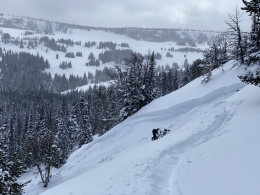
In the southern Madison and southern Gallatin Ranges and Lionhead area near West Yellowstone the snowpack is generally stable and avalanches are not likely. The last reported avalanche was a week ago in Taylor Fork, it was triggered by a snowbiker and broke on sugary snow near the ground (details). These mountains received less snow than the rest of the advisory area during the first half of February, and the weak snow near the ground is now better adjusted to handle the weight of a skier or rider (video). Today avalanches are unlikely and danger is LOW.
Upcoming Avalanche Education and Events
Our education calendar is full of awareness lectures and field courses. Check it out and plan to attend one or two: Events and Education Calendar.
COOKE CITY
Every Friday and Saturday, Snowpack Update and Rescue Training. Friday, 6:30-7:30 p.m. at the Soda Butte Lodge. Saturday anytime between 10-2 @ Round Lake.
BOZEMAN
March 4, 1-hr Avalanche Awareness. 6-7 p.m. at REI.
WEST YELLOWSTONE
TONIGHT! February 22, 1-hr Avalanche Awareness. 7-8 p.m. at West Yellowstone Holiday Inn.
Last Saturday, three motorized snowbikers were caught in an avalanche in Colorado and two were killed. We are deeply saddened by this accident. You can read the preliminary accident report here. Please take the time to learn what we can from this and all accidents. Stay safe if you are getting into the mountains today.