Good Morning. This is Ian Hoyer with the Gallatin National Forest Avalanche Forecast on Friday, February 21st at 7:00 a.m. Today’s forecast is sponsored by Ph.D. Skis and Stronghold Fabrication. This forecast does not apply to operating ski areas.
High pressure continues. There is no new snow this morning. Today’s weather will be similar to yesterdays, but with temperatures a few degrees higher and a little more wind. A morning inversion has valley temperatures in the single digits F and mountains temps in the teens and 20s F. Southwest winds at 10-20 mph will continue through the day. Temperatures will rise into the high 20s and low 30s F. Except more of the same tomorrow, before the pattern shifts on Sunday.

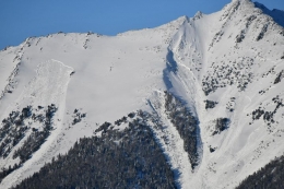
Without new snow to load them the weak layers that have been hanging out at the bottom of our snowpack all year are slowly gaining strength. However, recent large natural avalanches are a good reminder that slides on these weak layers are still possible if you find just the wrong spot. Yesterday, Alex looked at slides near Flathead Pass in the Bridger Range that broke 3-5’ deep and hundreds of feet wide earlier this week (photo, photo). Large avalanches also broke 3-4 days ago on the heavily wind loaded south face of Wilson Peak near Big Sky (photo). Unfortunately, we don’t have great tools to test weak layers at bottom of a deep snowpack. But we know the weak layer is there and has avalanched recently. Continuing to be conservative in your terrain selection is the best management strategy. Particularly avoid thin, rocky areas which are the most likely trigger points.
Yesterday, loose wet avalanches were seen on steep rocky slopes in the Bridger Range and near Cooke City. Wet point releases can start at your feet or come down from rocky slopes above you. Be especially mindful on higher consequence slopes where a small slide could push you over a cliff or into a gully. One of these wet loose slides triggered a thin slab avalanche on wind drifted snow north of Bridger Bowl (photo). This particular slab was thin but debris from a wet loose avalanche could also trigger a slide on the weak layers at the ground. Watch for roller balls and pinwheels as the day heats up and move to shadier or lower angled slopes once they start (photo).
With this combination of concerns, the avalanche danger is MODERATE today.

The snowpack is generally stable in the mountains around West Yellowstone. We’re a week out from the last reported avalanche (details). The weak snow at the ground is still there, but triggering an avalanche on it is unlikely (video). Watch out for the possibility of trigging small wet loose avalanches as the surface snow becomes wet with today’s warm temperatures and sunny skies.
Large avalanches are unlikely and the avalanche danger is LOW.
If you get out, please send us your observations no matter how brief. You can fill out an observation form, email us (mtavalanche@gmail.com), leave a VM at 406-587-6984, or Instagram (#gnfacobs).
Upcoming Avalanche Education and Events
Our education calendar is full of awareness lectures and field courses. Check it out and plan to attend one or two: Events and Education Calendar.
COOKE CITY
Every Friday and Saturday, Snowpack Update and Rescue Training. Friday, 6:30-7:30 p.m. at the Soda Butte Lodge. Saturday anytime between 10-2 @ Round Lake.
BOZEMAN
March 4, 1-hr Avalanche Awareness. 6-7 p.m. at REI.
WEST YELLOWSTONE
TOMORROW! February 22, 1-hr Avalanche Awareness. 7-8 p.m. at West Yellowstone Holiday Inn.
Last Saturday, three motorized snowbikers were caught in an avalanche in Colorado and two were killed. We are deeply saddened by this accident. You can read the preliminary accident report here. Please take the time to learn what we can from this and all accidents. Stay safe if you are getting into the mountains today.