Good Morning. This is Ian Hoyer with the Gallatin National Forest Avalanche Forecast on Friday, February 28th at 7:15 a.m. Today’s forecast is sponsored by Yellowstone Arctic Yamaha and Montana State Parks. This forecast does not apply to operating ski areas.
There is no new snow this morning. Mountain temperatures are in the teens and 20s F and winds are SW-NW at 10-20 mph with gusts of 25-35 mph. A beautiful spring day is in store, with sunny skies and temperatures climbing into the 30s F. Gusty west winds will continue through the day. Light snow is on the way tomorrow.

Strong and gusty west winds continue to drift snow (video). Avalanches can break in these drifts or if you get unlucky on weak snow near the ground. With a substantial load of new snow earlier this week, continued wind loading, and a history of big avalanches breaking at the ground we don’t have a lot of confidence in the snowpack (use the Weather and Avalanche Log to refresh your memory). Be particularly wary of freshly wind drifted slopes. Watch for shooting cracks as a sign the newly drifted snow is unstable.
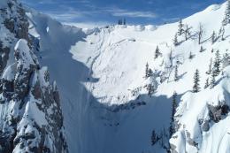
Yesterday, an avalanche broke 4 ft deep and 300 ft wide up Storm Castle creek and pushed the groomer off the trail (details). Luckily the operator was okay, but without the protection of his machine things could have turned out differently. On Wednesday, a cornice broke at the top of the Hourglass Chute north of Bridger Bowl and triggered a 3-4 foot deep x 100-foot wide slide on weak snow at the ground (photos and details). These slides are a clear demonstration that triggering avalanches on these weak layers is still possible. With a deeply buried weak layer capped by a hard slab it will take finding just the wrong spot to trigger a slide. Don’t pay attention to other tracks on a slope, it could easily be the 10th rider that triggers the monster avalanche.
The avalanche danger is rated MODERATE today.

The snowpack near Cooke City and West Yellowstone is generally stable. You could trigger small wind drifts, but these will not be much of an issue unless you’re in high consequence terrain. It has been several weeks since the last reported avalanche on the weak layers at the ground (video, video). However, yesterday skiers up Specimen Creek got a big collapse with the snowpack shifting an inch and a half downhill on a 30 degree slope (details). If the slope was just a few degrees steeper, it would have been an avalanche. Keep weak snow at the ground in the back of your mind and always be ready for the unlikely event that you do trigger a slide. The avalanche danger is rated LOW today.
If you get out, please send us your observations no matter how brief. You can fill out an observation form, email us (mtavalanche@gmail.com), leave a VM at 406-587-6984, or Instagram (#gnfacobs).
Upcoming Avalanche Education and Events
Our education calendar is full of awareness lectures and field courses. Check it out and plan to attend one or two: Events and Education Calendar.
COOKE CITY
Every Friday and Saturday, Snowpack Update and Rescue Training. Friday, 6:30-7:30 p.m. at the Soda Butte Lodge. Saturday anytime between 10-2 @ Round Lake.
BOZEMAN
February 27 - March 1, Bozeman Splitfest, More info and schedule here.
March 4, 1-hr Avalanche Awareness. 6-7 p.m. at REI.
March 6 and 7, She Jumps Companion Rescue Clinic, Fri 6-8 p.m. and Sat 10a-2p. More info and Register HERE.
BILLINGS
March 12, 1-hr Avalanche Awareness, 6-7 p.m. at The Basecamp.
Headed to the Sweet Grass County Recreation Association’s Poker Run tomorrow up the Main Boulder south of Big Timber? We went out yesterday to check on conditions before the ride, watch our video update HERE.