Good Morning. This is Dave Zinn with the Gallatin National Forest Avalanche Forecast on Tuesday, March 10th at 7:00 a.m. Today’s forecast is sponsored by Your Montana Chevy Dealers and Montana State Parks. This advisory does not apply to operating ski areas.
In the last 24 hours, the Northern Madison and the Northern Gallatin Ranges and mountains around Cooke City received 8-10” of new snow and the other ranges received 2-4”. Winds were 10-20 mph from the west and mountain temperatures are in teens to low 20s F. Today skies will become clear with west winds 10-20 mph and temperatures warming into the low 30s F.
WET SNOW AVALANCHES
Since Saturday night the mountains have received 8-14" of new snow. This new snow will rapidly destabilize as it warms up today and natural wet avalanches sliding on this weekend's melt-freeze crust are possible. When it becomes easy to form a snowball with the new snow and you start seeing small pinwheels rolling down slopes, move to shadier aspects because the change from stable to unstable can happen rapidly. Watch Ian's video from Mount Ellis to learn more. Today, the wet snow avalanche danger will increase to CONSIDERABLE and human triggered avalanches are likely.

The mountains around Cooke City and the Northern Gallatin and Madison Ranges received 8-10” of new snow last night bringing the three-day total to 15-20” at upper elevations. West to northwest winds are depositing snow on slopes that could avalanche today. Look for thick drifts and shooting cracks coming from your ski tips or sled as these indicate unstable slopes. This weekend skiers released a slab in a 40-degree chute in Middle Basin (details and photos) and observed loose snow avalanches on the east face of Mount Blackmore on Sunday (details and photo). Today, similar avalanches are possible in steep terrain. Avalanches breaking deeper into the snowpack are unlikely today, but, as a cornice triggered slide in Hyalite Canyon indicates, they are still an outside possibility (photo, video and details). In a video from Beehive Basin on Sunday we outline these issues.
Today, avoid wind loaded slopes and assess snowpack stability prior to entering avalanche terrain. Human triggered avalanches are possible, and the dry snow danger is rated MODERATE.
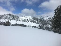
The Bridger, Southern Madison, Southern Gallatin and Lionhead Ranges received 8-12” of new snow since Saturday night. On Sunday the new snow avalanched under the weight of skiers and riders on Saddle Peak piling debris 5-6’ deep (details). The new snow gained strength since Sunday and, yesterday, in the Taylor Fork I found that dry snow avalanches would be unlikely and if they occurred they would be limited to the new snow (Skyline Ridge video). Remember that low danger does not equal no danger and in steep technical terrain, a small avalanche can have large consequences.
Today, give cornices a wide berth as they may break far back from the edge, assess slope stability and follow safe travel protocols. The dry snow danger is rated LOW and human triggered avalanches are unlikely.
If you get out, please send us your observations no matter how brief. You can fill out an observation form, email us (mtavalanche@gmail.com), leave a VM at 406-587-6984, or Instagram (#gnfacobs).
Upcoming Avalanche Education and Events
Our education calendar is full of awareness lectures and field courses. Check it out and plan to attend one or two: Events and Education Calendar.
COOKE CITY
March 13 and 14, Friday and Saturday, (last of the season) Snowpack Update and Rescue Training. Friday, 6:30-7:30 p.m. at the Soda Butte Lodge. Saturday anytime between 10-2 @ Round Lake.
BOZEMAN
March 26, GNFAC Forecaster Chat: Spring Travel and Wet Snow Avalanches, 6-8 p.m. at Uphill Pursuits.
BILLINGS
March 12, 1-hr Avalanche Awareness, 6-7 p.m. at The Basecamp.
Check out this cool website from the National Snow and Ice Data Center that gives a snapshot of the season’s snowfall across the western US.