Good Morning. This is Doug Chabot with the Gallatin National Forest Avalanche Forecast on Wednesday, December 30th at 7:00 a.m. This forecast is sponsored by Werner Wealth Management (Advisors with DA Davidson) and Community Food Co-op. This forecast does not apply to operating ski areas.
Under clear skies there is no new snow to report, but that will change today. Clouds will increase and winds will too. Currently west winds are blowing 15-20 mph with temperatures in the low teens. This afternoon west wind will be gusty at 30-40 mph from the west with temperatures reaching the low 20s. Scattered snowfall today and tonight will drop 1-3” by morning with the storm exiting later tomorrow.

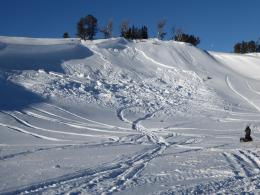
The snowpack in all our ranges except Cooke City is weak. Snow that fell in October rotted into sugary facets from exposure to clear skies and little snowfall. These grains do not bond well and they fall out of a fist like sand. These grains are weak and cannot support much weight. This layer is 1-2 feet thick and blankets the mountains from West Yellowstone to the Bridger Range, as well as most of the western US. Small snowstorms are slowly building a slab of meatier snow which the facets are struggling to support. Whumpfs, cracks, small avalanches, and unstable test scores are warnings from Mother Nature that the snowpack structure is poor. These signs have been reported 13 of the last 14 days. Yesterday, Ian and I rode into Buck Ridge and saw recent avalanches, had collapsing and cracking of the snowpack when we post-holed over to dig a snowpit, and got unstable test results. 3 pictures, one snowpit and a video document the problem through all these ranges.
It is not an issue of if avalanches will occur, but an issue of when. We need more snow to tip the scales towards widespread instability. Without the weight of new or wind blown snow being added to slopes the chances of triggering avalanches is decreasing, yet still possible. It is difficult to determine which slope will slide and which will not because the snow structure is uniformly bad everywhere. The only defense against this threat is to treat every slope with suspicion. It’s like driving on icy roads with bald tires; you can do it, but it might not end well.
For today the avalanche danger is rated MODERATE on all slopes since our snow structure is poor and triggering slides is possible.

Cooke City has a deep snowpack and only a few isolated instabilities. Without snowfall actively loading slopes, today’s concerns are limited to areas where the snowpack is thin and harboring weaker snow (i.e. in valley bottoms or near steep, craggy areas). Collapses (whumpfs) and cracks are a sign you found it. These mountains do not have widespread weak layers which makes it even more important to hunt for instability by digging and testing the snowpack before committing to avalanche terrain. Alex is in the area and reported that stability has improved from our visit last week. In the absence of new snow and widespread/persistent weak layers, the avalanche danger is rated LOW since natural and human triggered slides are unlikely.
If you get out, please send us your observations no matter how brief. You can submit them via our website, email (mtavalanche@gmail.com), phone (406-587-6984), or Instagram (#gnfacobs).
Upcoming Avalanche Education and Events
See our education calendar for an up to date list of all local classes. Here are a few select upcoming events and opportunities to check out:
Every Saturday in Cooke City, FREE snowpack update and rescue practice at the Round Lake Warming Hut between 10 a.m. and 3 p.m. Poster with More Info.
January 20 & 21 (plus field sessions the following weekends), Avalanche Fundamentals with Field Course. There are separate field sessions tailored for both skiers and splitboarders (Bridger Bowl) and snowmobilers (Buck Ridge). Register here.
A worthwhile read from Backcountry magazine: Four fatalities recorded in single weekend, amid “especially dangerous” avalanche conditions