Good Morning. This is Doug Chabot with the Gallatin National Forest Avalanche Forecast on Wednesday, February 24th at 7:15 a.m. Today's forecast is sponsored by World Boards and Mystery Ranch. This forecast does not apply to operating ski areas.
At 5 a.m. the Bridger Range got 4” overnight. In the last 24 hours 1-2” fell elsewhere except Lionhead. Wind has lessened to 10-15 mph from the W to SW with gusts to 25 mph. Mountain temperatures are in the single digits and will warm into the high teens with westerly wind at 10-20 mph. Scattered snow today will add 2-3” by late afternoon. Looking ahead, Thursday and Friday will be snowy and windy.

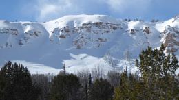
In the mountains around Bozeman and Big Sky westerly wind tapered off last night after raking the mountains with 45-100 mph gusts since Sunday. It snowed 3 to 4 feet last week and the strong wind added many more feet. Dave’s video standing under a 10-foot crown in MacAtee Basin on Buck Ridge illustrates the power of wind-loading. The snowpack quivered under these loads and on a few slopes it broke deep on sugary facets (depth hoar) near the ground. Alex investigated a deep slab avalanche on Mt. Blackmore last week (video) and another slide broke deep on Saturday on its north face (photo). Other deep slabs on Alex Lowe Peak and Flanders Mtn, plus a couple outside Big Sky Ski Resort (Lone Lake Cirque) leaves no doubt about the avalanche potential.
The previous three days of wind-loading remains a problem. I recommend staying off wind drifted slopes since triggering them is likely. Chalky, hard, and textured, avalanches involving these drifts are bad enough, but they could trigger a deeper slide. The avalanche evidence is all around us. For today the avalanche danger is rated CONSIDERABLE on all wind-loaded slopes and MODERATE on all others.
The avalanche concern in Cooke City are wind-loaded slopes from strong W-NW wind. Yesterday, Ian saw 2 wind slab avalanches on Mt Henderson from the Lulu road and 2 other skiers reported a small slide on Sheep Mountain and another on the east slopes of Republic Mountain (activity report). Although these avalanches were small, they indicate larger ones are not out of the question. Give wind-loaded slopes a wide berth since you are likely to trigger a slide. Thin snowpacks and/or rocky terrain are a secondary problem because these slopes harbor weak, faceted snow near the ground which can be triggered. Luckily they are found only in isolated areas, that is until you find one, then it’s unlucky. For today, the avalanche danger is rated CONSIDERABLE on all wind-loaded slopes and MODERATE on all others.

The mountains south of Big Sky to West Yellowstone have 2 competing issues: wind drifting and weak, faceted snow near the ground. Dave and I rode in Lionhead yesterday hunting for avalanches. The wind-loading was impressive with entire bowls of textured and drifted snow. Triggering a slide on a wind loaded slope may start small, but the initial avalanche could break deeper on facets. I made a video explaining these 2 concerns while standing near the debris of a slide from a few days ago (photo), and found more evidence of lurking instability from a recent cornice triggered avalanche (photo). The southern mountains got a full serving of wind and triggering slides on these wind drifted slopes is possible which points to a MODERATE danger. Avoiding wind-loaded terrain is a good strategy for today.
If you get out, please send us your observations no matter how brief. You can submit them via our website, email (mtavalanche@gmail.com), phone (406-587-6984), or Instagram (#gnfacobs).
The Beacon Park at Beall Park in Bozeman is running!
The Friends of the Avalanche Center in partnership with the City of Bozeman put in a Beacon Park at Beall Park. It is located on the north side of the Beall building between N. Bozeman Ave. and the ice rink. Stop by with your avalanche transceiver and do a few practice rescue drills. Your partner will thank you.
Upcoming Avalanche Education and Events
See our education calendar for an up-to-date list of all local classes. Here are a few select upcoming events and opportunities to check out:
Every Saturday in Cooke City, FREE snowpack update and rescue practice at the Round Lake Warming Hut between 10 a.m. and 3 p.m. Poster with More Info.
The US has reached 32 avalanche fatalities this season. With a lot of the avalanche season left we may reach 40 avalanche deaths for the first time since the winter of 1925-26. This is not a total we want to reach. A compilation of all avalanche fatality information can be found here.