Good morning. This is Ian Hoyer with the Gallatin National Forest Avalanche Forecast on Friday, March 1st at 7:00 a.m. Today’s forecast is sponsored by Ride Rasmussen Style, Bridger Bowl and Cooke City Motorsports. This forecast does not apply to operating ski areas.
2-4” of new snow have fallen in Hyalite, West Yellowstone and near Cooke City. The Big Sky and Island Park areas have 5-8” of new snow and the Bridger Range is the big winner with up to 10” of new snow falling in the last few hours. Winds have been very strong, consistently 25-30 mph out of the southwest and west with 50-80 mph gusts (up to 111 mph at Lionhead). Temperatures are in the teens and 20s F. High temperatures today will be in the 20s and low 30s F. Winds will remain strong and southwesterly. Snowfall today and tonight will bring 8-15” near Island Park, 6-12” near West Yellowstone and Cooke City, with just a few inches falling around Big Sky and Bozeman.

All Regions
It is snowing and blowing and human triggered avalanches are likely.
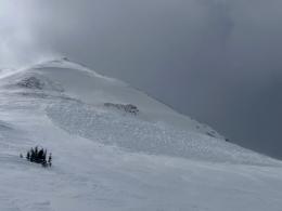
In places with more new snow, avalanches in that new snow will be easily triggered. Crazy strong winds have scoured some places and left big drifts in other, perhaps unusual, spots. A natural avalanche from down low in the trees below Mt. Blackmore two days ago provides a good example of the atypical, low elevation places you need to be worried about wind slabs, in addition to the more expected, higher elevation areas (observation and video). Avalanches breaking in these drifts are the likeliest problem you’ll encounter today and would be large enough to bury you. It’s going to be difficult to predict where these drifts have formed and with so much wind effect everywhere it may even be hard to see them before you’re on top of one.
The other major concern is the lurking dragon deep in the snowpack that we’ve been warning you about all season. The weak layers that have been consistently avalanching for the last two months are being loaded again. It’s been getting a bit harder to trigger a slide on these layers, but with a new load that all goes out the window for now. Avalanches have been seen across the advisory area over the last week and the sort of big, deep slides that were being triggered from hundreds of feet away a couple weeks ago are very much back on the table (Cedar Mountain, Sheep Mountain). These weak layers keep surprising us by how little it takes to wake them up. Keep your slope angles less than 30 degrees while we wait and see how they handle this loading event.
Dangerous avalanche conditions exist on all slopes, whether wind-loaded or not. If you get on a steep slope you will likely trigger a slide.
The avalanche danger is CONSIDERABLE across the advisory area.
If you get out please submit an observation. It does not need to be technical. Did you see any avalanches? How much snow is on the ground? Was the wind moving snow? Simple observations are incredibly valuable. You can also contact us by email (mtavalanche@gmail.com), phone (406-587-6984), or Instagram (#gnfacobs).
Upcoming Avalanche Education and Events
Our education calendar is full of awareness lectures and field courses. Check it out: Events and Education Calendar.
Friday evening (TONIGHT) and Saturday, March 1 and 2: Companion Rescue Course. More information and registration HERE.
March 8-10: Bozeman Splitfest. Check the Bozeman Splitfest website for event details and avalanche education opportunities offered by the Friends of the Avalanche Center.
Every weekend in Cooke City: Friday at The Antlers at 7 p.m., Free Avalanche Awareness and Current Conditions talk, and Saturday from 10 a.m.-2 p.m. at Round Lake Warming Hut, Free Rescue Practice.
Loss in the Outdoors is a support group for those affected by loss and grief related to outdoor pursuits. Check out the link for more information.
Clear weather and temperature fluctuations can make a weak layer in the top few cm of the snowpack called near-surface faceting. There are 3 dominant types which are explained in Bruce Jamieson’s new video featuring Karl Birkeland, Doug Chabot, Ed Adams, Mike Cooperstein, Ethan Greene and Mark Staples.