Good morning and Happy Leap Year! This is Doug Chabot with the Gallatin National Forest Avalanche Forecast on Thursday, February 29th, at 6:45 a.m. Today’s forecast is sponsored by Uphill Pursuits and Avalanche Alliance. This forecast does not apply to operating ski areas.
Yesterday, the mountains south of Big Sky and Cooke City got 1-2” of snow. Wind is very strong out of the W-SW averaging 20-30 mph with gusts of 35-66 mph. In Cooke City it is blowing 10-25 mph. Today will be partly cloudy in the north and mostly cloudy in the south with temperatures remaining in the high teens to low 20s F. A snow storm moves in tonight through Saturday. By tomorrow morning 1-2” will fall around Bozeman and Big Sky, and 4-5” around West Yellowstone, Island Park and Cooke City. Wind will remain strong at all elevations today.

Yesterday, near Mt. Blackmore in Hyalite, skiers saw fresh avalanche debris near the trail. It was likely from a wind-loaded slope at low elevation, indicative of the instability that would be found higher (observation and video). A skier also had collapsing and cracking as he toured above the reservoir (observation). Throughout the forecast area wind is blowing at all elevations and scraping away the fresh snow into thick drifts which are dangerous and could be triggered. The snowpack remains unstable and avalanches were seen on Buck Ridge, Taylor Fork, Lionhead and Cooke City in the last week (details). The weight of recent wind drifts are making slopes unstable. In Taylor Fork on Tuesday we warned of new snow and wind creating instability, which is still true today (observation and video).
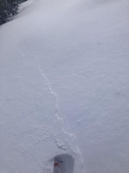
Dangerous avalanche conditions can be found on all slopes, wind-loaded or not. A person is likely to trigger a slide if they get into avalanche terrain. Even small slopes can avalanche (photo) and these point to instability that can be found on bigger slopes (photo). Alex’s field days in Cooke City bear this out. He found wind-loading and heaps of weak snow (video), which is a similar story to all the mountain ranges from Bozeman to Big Sky to West Yellowstone, Island Park and Cooke City. These mountains have a CONSIDERABLE avalanche danger on all slopes.
Powerful wind is blowing at the ridgetops and mid-mountain elevations in the Bridger Range. Most new snow has already been scoured into drifts, but these strong winds will scrape every last flake (photo). Wind-loaded slopes are dangerous. Yesterday Dave saw an avalanche that occurred on Saddle Peak from wind-loading (photo), and Ian and I could see plumes of swirly snow being deposited north of the Ramp. Expect to find thick wind drifts in gullies and slopes below cornices. These could be easily triggered. Our 5’ deep snowpit showed signs of strengthening which gave us a tiny glimmer of hope, but I am still skeptical (observation and video).
Avoid wind-loaded slopes today since these have a CONSIDERABLE avalanche danger. Slopes without a wind-load will have a MODERATE danger.
If you venture out, please fill an observation form. It does not need to be technical. Did you see any avalanches? How much snow is on the ground? Was the wind moving snow? Simple observations are incredibly valuable. You can also contact us via email (mtavalanche@gmail.com), phone (406-587-6984), or Instagram (#gnfacobs).
Upcoming Avalanche Education and Events
Our education calendar is full of awareness lectures and field courses. Check it out: Events and Education Calendar.
Friday evening and Saturday, March 1 and 2: Companion Rescue Course. More information and registration HERE.
March 8-10: Bozeman Splitfest. Check the Bozeman Splitfest website for event details and avalanche education opportunities offered by the Friends of the Avalanche Center.
Every weekend in Cooke City: Friday at The Antlers at 7 p.m., Free Avalanche Awareness and Current Conditions talk, and Saturday from 10 a.m.-2 p.m. at Round Lake Warming Hut, Free Rescue Practice.
Loss in the Outdoors is a support group for those affected by loss and grief related to outdoor pursuits. Check out the link for more information.
Clear weather and temperature fluctuations can make a weak layer in the top few cm of the snowpack called near-surface faceting. There are 3 dominant types which are explained in Bruce Jamieson’s new video featuring Karl Birkeland, Doug Chabot, Ed Adams, Mike Cooperstein, Ethan Greene and Mark Staples.