Good morning. This is Doug Chabot with the Gallatin National Forest Avalanche Forecast on Wednesday, February 28th at 6:45 a.m. Today’s forecast is sponsored by World Boards and Mystery Ranch. This forecast does not apply to operating ski areas.
Yesterday, the Bridger Range picked up 4” of new snow, the Big Sky area got 3” and 1-2” fell everywhere else. Wind is blowing strong from the SW-W at 20-25 mph with gusts hitting 40-55 mph at the ridgetops. Temperatures are in the low single digits F. Today will be mostly sunny in the north and cloudy in the south with temperatures reaching 20F. Wind will become even stronger through the day with gusts of 60 mph. Only a trace of snow is expected in the southern ranges.

All Regions
Dangerous avalanche conditions exist throughout our forecast area. Around Cooke City and in the southern Madison and southern Gallatin Ranges there was enough new snow Sunday and Monday to issue Avalanche Warnings. The other areas also got snow and strong westerly wind which picked up again last night and is predicted to continue. New snow and wind creates thick drifts which can be easily triggered. This was our main concern as we rode around Taylor Fork yesterday (observation and video).
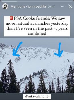
Since Sunday, Cooke City got 20” of snow while 8-12” fell everywhere else. This new snow is ammunition for the wind to build thick drifts. These winds are blowing at all elevations, not just ridgelines. We saw scoured sub-ridges on Skyline Ridge by Cabin Creek yesterday. These are indicative that gullies and lower slopes are also being loaded. Alex snapped a picture of a large recent avalanche north of Cooke City on Scotch Bonnet that was heavily wind-loaded (observation).
As far as the snowpack is concerned, it’s still snowing out because the wind continues to load slopes. As Alex points out in his video from Cooke City, the snowpack is the weakest he’s ever seen. All other mountain ranges in our forecast area have a similar theme: a weak and unstable snowpack is getting an additional load of windblown snow.
Triggering large avalanches 2-4 feet deep remains likely, wind-loaded or not. It may be difficult to assess exactly where the wind-loads are, so treat all slopes suspiciously. Staying out of avalanche terrain is a wise move. In the last 5 days there have been avalanches in Cooke City, Taylor Fork, Lionhead and around Big Sky (details). Recent avalanches are the #1 sign slopes are unstable.
The danger is rated CONSIDERABLE on all slopes in our forecast area.
If you venture out, please fill an observation form. It does not need to be technical. Did you see any avalanches? How much snow is on the ground? Was the wind moving snow? Simple observations are incredibly valuable. You can also contact us via email (mtavalanche@gmail.com), phone (406-587-6984), or Instagram (#gnfacobs).
Upcoming Avalanche Education and Events
Our education calendar is full of awareness lectures and field courses. Check it out: Events and Education Calendar.
Friday evening and Saturday, March 1 and 2. Companion Rescue Course. More information and registration HERE.
March 8-10. Bozeman Splitfest. Check the Bozeman Splitfest website for event details and avalanche education opportunities offered by the Friends of the Avalanche Center.
Every weekend in Cooke City: Friday at The Antlers at 7 p.m., Free Avalanche Awareness and Current Conditions talk, and Saturday from 10 a.m.-2 p.m. at Round Lake Warming Hut, Free Rescue Practice.
Clear weather and temperature fluctuations can make a weak layer in the top few cm of the snowpack called near-surface faceting. There are 3 dominant types which are explained in Bruce Jamieson’s new video featuring Karl Birkeland, Doug Chabot, Ed Adams, Mike Cooperstein, Ethan Greene and Mark Staples.