Good Morning. This is Doug Chabot with the Gallatin National Forest Avalanche Advisory issued on Tuesday, March 6th at 7:00 a.m. Today’s advisory is sponsored by Montana State Parks and Gallatin County Search and Rescue. This advisory does not apply to operating ski areas.
Overnight the Big Sky area picked up 3” of new snow with 1-2” falling everywhere else. Winds are averaging 15-20 mph out of the west with gusts of 30 mph. Mountain temperatures are in the single digits. Today will become partly cloudy as high pressure builds across Montana. Temperatures will reach the 20s and winds will be light from the west-southwest. No new snow is expected in the next couple days.

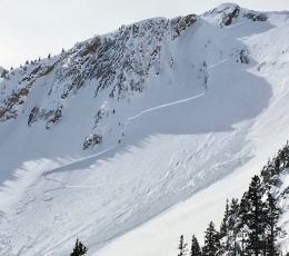
A few inches of new snow (.1-.2” of snow water equivalent) with west winds will keep alive the possibility of triggering wind-loaded slopes. Wind slabs from the weekend are 1-3’ thick. On Sunday a skier triggered a small slide above Hebgen Lake (photo, photo) and we could see something similar today. Near Ross Peak in the Bridger Range a skier dug a snowpit and easily broke a 2’ thick wind slab in his stability test, a warning of avalanche potential. Most wind slabs will be found along ridgelines, but a few may lurk in mid-elevation gullies.
At the ridge crest, massive cornices could break from the weight of a passing skier. These are doubly dangerous as not only would you tumble off alongside a literal ton of snow, but sometimes these car-sized chunks trigger avalanches (photo, illustration).
Alex and I were in Bacon Rind on Sunday and our only avalanche concern was new snow and wind-loading (video, snowpit). Throughout out forecast area the snowpack is generally stable and the likelihood of triggering avalanches is decreasing. Without obvious signs of instability, like a fresh avalanche, we may fool ourselves into thinking that all slopes are safe. This is why it is important to carry rescue gear and travel one at a time in avalanche terrain. These actions are our last line of defense in case we are wrong in our assessment.
For today, the avalanche danger is rated MODERATE on all wind-loaded slopes and LOW on all others.
If you get out and have any avalanche or snowpack observations to share, drop a line via our website, email (mtavalanche@gmail.com), phone (406-587-6984), or Instagram (#gnfacobs).
Upcoming Avalanche Education and Events
BOZEMAN
March 7th, Avalanche Awareness, 6-7:30 p.m. @ REI
LIVINGSTON
March 20, Beer for a Cause Night at Katabatic Brewing, 4-8p.m. A dollar from every pint will be donated to The Friends of the Avalanche Center.
COOKE CITY
March 10th, Upper Yellowstone Snowmobile Club Annual Hog Roast, Cooke City, festivities from 7am – 7pm. Schedule Here.
Friday and Saturday, Current Conditions Update and Avalanche Rescue, Friday 6:30-7:30 p.m. at The Soda Butte Lodge. Saturday anytime between 10-2 @ Round Lake.
In the last 10 days there have been 6 avalanche fatalities: 2 snowshoers and 3 snowmobilers in WA, and 1 snowboarder in AK. Our snowpack is a lot more stable than other areas of the west, but let’s not let our guard down. More info on the accidents is here: https://avalanche.org/avalanche-accidents/