Good morning. This is Eric Knoff with the Gallatin National Forest Avalanche Forecast issued on Friday, March 1st at 7:00 a.m. Today’s forecast is sponsored by Community Food Co-op and Lawson Dental. This forecast does not apply to operating ski areas.
AVALANCHE WARNING
The Gallatin National Forest Avalanche Center is continuing a Backcountry Avalanche Warning for the Southern Gallatin and Southern Madison Ranges, the Lionhead area near West Yellowstone, the Centennial Range, and the mountains around Cooke City. Heavy snowfall and strong wind are creating very dangerous avalanche conditions. Natural and human triggered avalanches are likely. Avalanche terrain and avalanche runout zones should be avoided. The avalanche danger is rated HIGH on all slopes.
AVALANCHE FATALITY
On Tuesday, a solo skier was killed in an avalanche on the west side of the Bridger Range in Truman Gulch. Here is a 4-minute video outlining the circumstances of the fatal accident: video. A full written report will be released later today.
Over the past 24 hours the mountains picked up 4-7” of new snow. At 5 a.m. snow has tapered off and skies are beginning to clear. Temps are in the single digits F and winds are blowing 15-35 mph out of the west-northwest. Today, skies remain partly to mostly cloudy and temps warm into the teens. Winds will continue to blow 15-30 mph out of the west-northwest. The mountains could see 1-2” of snow tonight, but snowmageddon appears to be letting up for the next few days.

Avalanche Warning
The snowpack in these areas is heavily loaded and remains under a significant amount of stress. Over the past week, the mountains near Cooke City, West Yellowstone, including the Sothern Madison and Gallatin Ranges - have received 4-6’ of snow totaling 4-7” of SWE. This is an insane amount of snow and water weight!
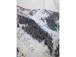
Every structure has a breaking point and the snowpack is no different (video). Today, natural and human triggered avalanches are likely on all steep slopes. A large natural avalanche that crossed Hwy 287 near Quake Lake yesterday is a perfect example of what’s possible today (photo). Slides will break deeper and run farther than expected. Under these conditions it’s very easy to get surprised.
Traveling in the backcountry today requires expert terrain management. It’s imperative that all backcountry travelers stay off and out from underneath all steep slopes (photo). This includes small terrain features such as road cuts, roll overs and creek bottoms.
Today, very dangerous avalanche conditions exist and the avalanche danger is rated HIGH.

The mountains near Bozeman and Big Sky have picked up 2-3’ of snow totaling 2-3” of SWE over the past week. This hasn’t been quite enough load to create a widespread avalanche cycle, but is has pushed the snowpack near it’s breaking point.
Wind loaded slopes will be the most unstable and could fail naturally today (video). The avalanche fatality two days ago in the Bridger Range is a sad reminder of how unstable wind loaded slopes can be (details, photos). A skier triggered slide two days ago on a wind loaded slope near Big Sky is also bull’s eye information wind loaded slopes are unstable (photo)
Non-wind loaded slopes are also getting pushed to a dangerous level by the heavy new snow. Yesterday, skiers on the Throne in the northern Bridgers observed recent avalanche activity in the new snow and got unstable test results on a weak interface a foot below the surface (photo). Today, human triggered slides breaking 1-2’ in depth on non-wind loaded slopes are likely.
For this reason the avalanche danger is rated CONSIDERABLE on all slopes.
If you get out and have any avalanche or snowpack observations to share, contact us via our website, email (mtavalanche@gmail.com), phone (406-587-6984), or Instagram (#gnfacobs).
Upcoming Avalanche Education and Events
Our education calendar is full of awareness lectures and field courses. Check it out: Events and Education Calendar.
BOZEMAN
Today, March 2 and 3, Bozeman Split Fest, More info at www.bozemansplitfest.com.
March 6, 1-hr Avalanche Awareness, 6-7 p.m. at REI Bozeman.
COOKE CITY
Every Friday and Saturday, Rescue Training and Snowpack Update. Friday 6:30-7:30 p.m. at the Soda Butte Lodge. Saturday anytime between 10-2 @ Round Lake.
Seventeen people have died in avalanches across the U.S this winter (‘18/’19). Take a few minutes to read this season’s avalanche fatality reports. These reports provide a great opportunity to learn from these tragic accidents.