Good Morning. This is Dave Zinn with the Gallatin National Forest Avalanche Forecast on Monday, February 22nd at 7:15 a.m. Today's forecast is sponsored by Bridger Bowl and Cooke City Motorsports. This forecast does not apply to operating ski areas.
Strong winds in the northern ranges are blowing 25-30 mph from the west gusting to 70 mph. In the southern ranges, the wind is 10-20 mph from the southwest. Temperatures are in the mid-teens to mid-20s F, and the mountains south of Big Sky and near Cooke City received 2-4” of new snow.
Temperatures will climb into the 30s today in the northern ranges and into the 20s in the southern ranges. Strong winds will continue blowing 25-35 mph from the west to southwest and there will be 8-10” of new snow in Cooke City, 2-4” in Big Sky and West Yellowstone, and a trace to 2” in the Bridger Range.

Strong winds gusting into the 70s mph are loading snow into dense slabs are keeping the snowpack in the Bridger, Northern Madison, and Northern Gallatin Ranges on edge. During routine inbounds, avalanche mitigation work, the Bridger and Big Sky Ski Patrols noted fresh drifts of wind-loaded snow avalanching up to 12-14” deep and the Big Sky Ski Patrol saw two new avalanches in the backcountry that broke on deeply buried weak layers. Similar wind-slabs in the backcountry will likely break 1-2’ deep and outliers like Saturday’s 10’ deep snowmobile-triggered avalanche in McAtee Basin are possible (photo, video). While climbing yesterday, Doug said he “would not entertain getting in the wind-loaded gullies in Hyalite”.
Notable avalanche activity in the last week:
- Natural avalanche in the Northern Madison Range yesterday (photo)
- Natural slide on the ridge north of Mount Blackmore Saturday or Sunday (details and photo)
- 3.5’ deep, snowmobile-triggered avalanche at the entrance to McAtee Basin on Saturday (photo)
- Very large, natural avalanches late last week on Mount Blackmore (video, photos and details), Alex Lowe Peak (photo), and on Flanders Mountain (photos and details)
- Large, natural avalanche breaking near the ground south of Bridger Bowl (photos)
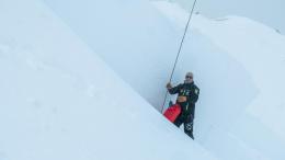
- A fatal avalanche in Beehive Basin last Sunday (details and information)
Avoid travel on or below steep, wind-loaded slopes where the danger is rated CONSIDERABLE and human-triggered avalanches are likely. Human-triggered slides are possible on steep, non-wind-loaded slopes and the danger is MODERATE.

The Southern Gallatin Range, Southern Madison Range, and Lionhead area have a layer of weak facets near the ground that heighten the avalanche danger and make large, human-triggered avalanches possible. Skiers in the Southern Gallatin Range yesterday noted a recent natural avalanche and two large whumphs (photo). While there was not as much new snow or wind, the weak structure of the snowpack makes large, deep-slab avalanches possible. Pay special attention to slopes with recent drifts that add weight and stress to the snowpack and utilize a conservative mindset during a season plagued by deeply buried instabilities. The avalanche danger is MODERATE.
Light snowfall continued in the mountains around Cooke City with 2-3” new in the last 24-hours. This snow will be blown into soft wind-slabs sensitive to human-triggers. Larger avalanches breaking deeper into drifted snow and slides initiating in the thinner, weaker snowpacks that exist in some starting zones are possible. See my video from last week for further discussion about this or look at the photo of the snowmobile-triggered avalanche on Crown Butte from last Thursday for a recent example. A skier on Town Hill got a large collapse yesterday that clearly indicates this persistent, though limited, problem is still with us (details). Human-trigger avalanches are possible and the danger is rated MODERATE. Evaluate the snowpack and terrain carefully to identify and avoid areas of concern. As snowfall intensifies today, the avalanche danger will increase. Look for signs of increasing instability and adjust travel plans accordingly.
If you get out, please send us your observations no matter how brief. You can submit them via our website, email (mtavalanche@gmail.com), phone (406-587-6984), or Instagram (#gnfacobs).
BEEHIVE BASIN AVALANCHE ACCIDENT REPORT
We posted a detailed report from Sunday's fatal avalanche in Beehive Basin here.
The video of our accident investigation from the field is here.
Upcoming Avalanche Education and Events
See our education calendar for an up-to-date list of all local classes. Here are a few select upcoming events and opportunities to check out:
Every Saturday in Cooke City, FREE snowpack update and rescue practice at the Round Lake Warming Hut between 10 a.m. and 3 p.m. Poster with More Info.
TONIGHT!!! February 22, 6-7 p.m., Forecaster Chat: Rethinking Avalanche Terrain from a Strategic Perspective, Hosted online by Uphill Pursuits, Link to Join HERE
There was a snowmobiler killed in an avalanche on Friday in Central Idaho (preliminary report from S.A.C.), Saturday in Eastern Idaho (News Release), and another Saturday near Elko, Nevada (News Release). This makes 31 fatalities this season. Be safe out there.