Advisory Archive
Under sunny skies and light winds, mountain temperatures rose to 32F yesterday but never reached t-shirt warmth. That will change today. Under partly cloudy skies mountain temperatures will rise from the teens this morning into the low 40s by mid-afternoon and drop below freezing tonight. Ridgetop winds are 10-15 mph out of the west to southwest and will remain light. A ridge of high pressure brings warm and calm weather over the next few days.

This morning there is no new snow to report. Temperatures are in the single digits and winds are blowing 5-15 mph out of the west. Today, skies will be clear and temperatures will warm into the mid to upper 20s. Winds will continue to blow 5-15 mph out of west. A ridge of high pressure will remain parked over the region over the next few days producing clear skies and warmer temperatures.
Overnight the mountains picked up a trace of new snow. This morning temperatures are ranging from the single digits above or below zero F and winds are light out of the WNW blowing 5-10 mph. Today, a cold northwest flow will allow highs to warm into the upper teens to low 20s F and winds will stay light out the WNW. Skies will stay partly to mostly cloudy with both sun and light snow showers likely throughout the day. A ridge of high pressure will build this evening producing clear skies and warmer temperatures tomorrow.
Overnight three inches of low density snow fell in the Bridger Range. A trace to one inch fell elsewhere. At 4 a.m. temperatures are in the single digits above or below zero F and winds are blowing 5-10 mph out of the WNW. Today, temperatures will stay well below average with highs warming into the teens F and winds will stay light out of the WNW blowing 5-10 mph. Skies will start out partly to mostly cloudy this morning, but will become obscured by this afternoon as another round of moisture arrives from the north. 1-3 inches is possible by tomorrow morning in the mountains around Bozeman and Big Sky. The southern mountains will see a trace on one inch.

Since yesterday morning, Hyalite Canyon received 4 inches of new snow. Most other places received 1-2 inches while the mountains near West Yellowstone got a trace at best. Temperatures this morning dropped into the single digits F and winds were blowing 10 mph gusting to 15 mph from the W. Yesterday winds blew 20 mph gusting to 40 mph from the W.
Weather for the next few days should be perfect for preserving snow quality: cold temperatures, light winds, and not too much strong sunshine. Today temperatures will struggle to reach the teens F and winds will shift to the N and blow 5-10 mph. About an inch of snow should fall this afternoon.
Snow fell yesterday and early this morning. In most places snowfall was ending this morning with 24 hour totals of 4 inches in the Bridger and Northern Gallatin Ranges and 6-8 inches everywhere else. Winds were blowing 15-20 mph and gusting to 35-50 from the SW. As temperatures began dropping into the teens F, winds eased and shifted to the W. Today will be cold with temperatures reaching the low teens F. Mostly cloudy skies will produce snow with 1-3 inches by tomorrow morning. Winds will blow from the W at 10-15 mph with gusts of 25.
Another inch of snow fell in the southern mountains before the skies cleared yesterday morning. By afternoon temperatures rose into the mid-20s, westerly winds decreased and sunny skies prevailed. Mountain temperatures are still near 20F with winds averaging 15-25 mph out of the southwest. Today will start cloudy, get sunny later this morning, then cloud over again. Mountain temperatures are expected to climb above freezing. Tonight a moist disturbance from the southwest will drop freezing levels and bring snow, favoring the southern mountains. By morning there should be 3-6 inches.
Last night four inches of new snow fell in the northern Gallatin Range with 1-2 inches covering the rest of our area. Winds are averaging 20-25 mph out of the west with gusts hitting 50 mph. This morning mountain temperatures are near 10F, but will warm into the upper 20s by this afternoon. Today will be dry and sunny with winds tapering off. There’s no snow expected in the next 24 hours, but we are poised to get moisture later tomorrow. Moisture is code for “it might be rain”.
Yesterday’s storm totals averaged 4-6 inches in most mountain locations. The Bridger Range was the big winner with a total of 9 new inches. This morning, clear skies have allowed temperatures to drop into the single digits F and winds are blowing 10-20 mph out of the WNW. Today, highs will climb into the upper teens to mid-twenties F under partly to mostly cloudy skies and winds will continue to blow 10-20 from the WNW. A light weather disturbance will move over the area this afternoon producing a chance for mountain snow showers. 1-2 inches is possible by tomorrow morning.
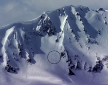
Overnight 3-5 inches of snow fell in most mountain locations. Currently, it’s still snowing and temperatures are in the upper teens to low twenties F. Winds are blowing 15-30 mph out of the west with ridgetop gusts reaching close to 40 mph. Today, temperatures will continue to drop as a cold front moves over the area. By noon, temperatures will be ten degrees colder and winds will continue to blow 15-30 mph out of the west/northwest. Snow will continue through the day with an additional 2-4 inches likely by this evening. With new precipitation, a rainbow may appear today but don't expect to find a fat pot of gold at its base – we’re still be dealing with dust on crust conditions.