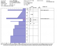
Advisory Archive
Since yesterday the mountains near Cooke City received 5 inches of snow and all other places received 1-3 inches. This morning temperatures were in the low teens F, and gusty winds were blowing 15 mph from the W and NW with gusts of 20-30 mph. Mostly cloudy skies today will keep temperatures in the teens F, and winds will continue blowing 15-30 mph from the W and NW. Snowfall tonight will bring 1-3 inches by tomorrow morning.

Yesterday morning 3-4 inches of snow fell around Big Sky with other areas receiving just a trace to one inch. Winds are still cranking from the west in the Bridger Range and Hyalite area at 30-50 mph; all other weather stations are measuring 15-30 mph. Under cloudy skies temperatures are in the mid-teens. A moist northwest flow will drop 1-2 inches of snow today with mountain temperatures reaching the mid-20s and wind speeds remaining the same.

Last night a trace to one inch of snow fell in the southern mountains. Currently, westerly winds are blowing 10-20 mph except in the Bridger Range and Hyalite where they are reading 30-40 mph. Temperatures are near 10F under partly cloudy skies. Today will be partly to mostly cloudy with winds increasing out of the west to northwest. A trace to one inch may fall later tonight.

Over the past 24 hour a trace to one inch of snow has fallen in the mountains. At 4 a.m. temperatures are in the single digits above or below zero and winds are blowing 10-20 out of the west. Today, clear skies and abundant sunshine will allow temperatures to warm into the upper teens to low twenties F and winds will remain out of the west at 10-20 mph. The building ridge of high pressure will begin to break down tonight increasing the chance of cloudy skies and light precipitation by tomorrow.

Overnight, a fast but intense storm delivered eleven inches of snow to the northern Gallatin Range and eight inches to the mountains around Big Sky. Strangely enough the southern Madison Range picked up two inches while the Lionhead Area, Bridger Range and mountains around Cooke City squeaked out a trace to one inch. Currently, temperatures are in the single digits F and winds are blowing 10-20 out of the N with gusts reaching close to 30 mph. Highs today will climb into the teens and winds will remain out of the north at 10-20 mph. Snow showers will linger in the mountains through the morning hours, but skies will gradually begin to clear by this afternoon. Clear skies and colder temperatures will be on tap for tomorrow.
Since yesterday morning a trace to one inch of snow fell in the mountains around Big Sky and West Yellowstone; all other areas remained dry. Currently, temperatures are ranging from the single digits to low teens and winds are blowing 5-15 mph out of the ENE. Today, temperatures will warm into the 20s F under partly to mostly cloudy skies and winds will blow 5-15 from the NNE. A Canadian cold front with a limited amount of moisture will impact our area tonight into tomorrow. The mountains around Bozeman, Big Sky and Cooke City will likely see 2-4 inches of snow by tomorrow afternoon. The mountains around West Yellowstone will pick up 1-3 inches.
Under partly cloudy skies and very light winds, mountain temperatures are in the upper teens this morning. For the next 24 hours winds will remain 5-15 mph out of the southwest with temperatures reaching the mid-20s under increasing cloud cover. A few flurries may dust the southern ranges, but no accumulation is expected. Tomorrow the weather pattern will change in favor of snow, so do not despair.
Under clear skies this morning, mountain temperatures were in the mid-teens F and SW winds were blowing 10-15 mph gusting to 25 mph. Today an upper level ridge will move east and some clouds will move over the area. Temperatures should climb only a few degrees to near 20 F and winds will continue the same. Some snow will come Friday followed by cold temperatures on Sunday.

At 5 a.m. there’s no new snow to report. Westerly winds are averaging 10-15 mph with gusts to 30 mph under clearing skies. Mountain temperatures are near 20F. Today will be partly cloudy as winds remain the same and temperatures rise into the high 20s. High pressure is building and there will be little chance of precipitation over the next few days.
This morning mountain temperatures were near 20 degrees F. Westerly winds were blowing 20 gusting to 40 mph in the Bridger Range and northern Gallatin Range. In all other areas westerly winds were blowing 10 gusting to 20 mph. Since yesterday, Hyalite Canyon and the mountains near Cooke City received about an inch of snow. A few other places received a trace. Cloudy skies this morning may produce another dusting and maybe an inch in places. Without much sunshine today, temperatures shouldn’t warm too much. Winds may increase a little and back to the SW.