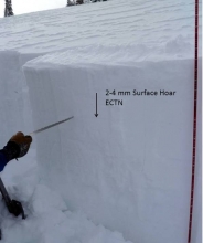
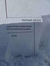
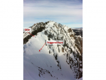
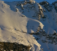
Advisory Archive
On a northwest flow Bridger Bowl picked up six inches last night with four inches around Big Sky and 1-3 inches everywhere else. Mountain temperatures are near ten degrees, except around Cooke City and West Yellowstone where they are minus five. Winds are west to northwest at 20-35 mph. High pressure shoves its way in this afternoon and will stay for a few days. An additional trace to one inch may fall this morning as temperatures warm into the high teens under clearing skies. Winds will remain steady at 20-30 mph out of the northwest.


Since yesterday morning a trace of new snow fell in the northern mountains while the southern mountains remained dry. Currently, temperatures are frigid at 10-15 below zero F and winds are blowing 5-15 mph out of the WNW with the exception of the Bridger Range where winds are blowing 15-25 mph. Today, the mercury will climb into the single digits above zero under partly to mostly cloudy skies. Winds will remain out of WNW blowing 10-20 mph. There is a chance the winds could pick up this afternoon as a storm approaches from the north. Snow is likely tonight with 2-4 inches possible in the mountains around Bozeman and Big Sky. The mountains around West Yellowstone will see 1-3 inches and Cooke City will likely be the winner picking up 4-6 inches.
Over the past 24 hours a trace to one inch of snow has fallen in the mountains. This morning temperatures are ten to fifteen below zero F and winds are light out of the NW blowing 5-10 mph. Today, high temperatures will be in the single digits above or below zero F under mostly cloudy skies and winds will stay light out of NW. A weak weather disturbance will bring light snow showers to the mountains where a trace to one inch is possible. A stronger system is forecasted to impact the area tomorrow night into Tuesday.
Over the past 24 hours the mountains picked up a trace to one inch of snow. Temperatures this morning are ranging from five to fifteen below zero F and winds are light out of the NW blowing 5-10 mph. Today, skies will be mostly clear in the morning but will become partly to mostly cloudy by this afternoon. Temperatures will remain cold with highs climbing into the single digits above zero F and winds will remain light out of the NW. Light snow showers could develop late this evening, but no real accumulations are expected. Temperatures will gradually start to warm up by Monday.


Since yesterday, the southern Madison Range and the mountains near West Yellowstone area received 8-10 inches of new snow. The Bridger Range and northern Gallatin Range received 4-5 inches while the mountains near Big Sky and Cooke City received a paltry 2 inches. Temperatures this morning were near 0 degrees F and northerly winds were fortunately only blowing 5-10 mph. Today northerly winds will increase to 10-15 mph and temperature should drop to about -10 degrees F. Snowfall will continue until this afternoon and produce an additional 2-3 inches in most areas. Very cold temperatures will last thru this weekend.
No snow fell yesterday or overnight, but snowfall started this morning near West Yellowstone with 2 inches of new snow at 6 a.m. and snow just beginning near Big Sky. This morning, mountain temperatures were mostly in the 20s F except in the Bridger Range where temperatures were near freezing. Winds eased a little this morning and were blowing 10-20 mph from the SSW with gusts of 30 mph; however, winds remained strong in Hyalite Canyon where they were averaging 30 mph with gusts of 50 mph.
A slow-moving winter storm will bring snowfall throughout the advisory area today. Temperatures should drop a few degrees and reach 0 F by tomorrow morning. Winds will also decrease. By tomorrow morning 8-10 inches of snow will fall near in the mountains West Yellowstone and Cooke City, 6-8 near Big Sky, and 3-6 near Bozeman. All the meteorological factors for snow are aligning well today making higher snow amounts possible. Snowfall will continue through Friday.
In the last 24 hours the southern mountains have picked up 2-4 inches of new snow while the northern mountains received only a trace to an inch. Mountain temperatures are in the mid-twenties with south to southwest winds averaging 20-30 mph and gusts in the 40s. Today will be warm and windy under partly cloudy skies. Tonight clouds will increase and snow showers will drop 2-3 inches of snow down south and a trace to one inch in the northern mountains.
In the last 24 hours 1-2 inches have fallen around Bozeman, 3-4 inches around Big Sky, 4-5 inches near West Yellowstone and 8 inches outside Cooke City. Mountain temperatures are in the teens with west to southwest winds averaging 20-30 mph and gusting to 50 mph. Today will be cloudy with temperatures rising to near 20F as winds continue to blow strong out of the west to southwest. By morning a trace to one inch of new snow is expected, but don’t fret, much more is slated for Thursday.


Over the past 24 hours 1-2 inches of snow has fallen over much of the forecast area except for the Bridger Range which squeezed out a trace. Currently, temperatures are in the teens F under mostly cloudy skies and winds are blowing 15-30 out of WNW. Today, temperatures will warm into the mid to upper 20s F and winds will remain out of the west blowing 15-30 mph. A stronger storm system is scheduled to arrive this afternoon bringing an increased chance of snow to the mountains. 2-4 inches is likely by tomorrow morning with the exception of the Bridger Range which will see 1-2 inches.
There is no new snow to report, but a weak weather disturbance could deposit a trace to one inch of snow by this afternoon. This morning mountain temperatures are in the 20s F with the exception of the West Yellowstone area where temperatures are in the single digits. Winds are blowing 15-30 out of the WSW with gusts in Hyalite reaching close to 50 mph. Today, temperatures will warm into the upper 20s to low 30s F and winds will continue to blow 15-30 out of the WSW. There is a chance of mountain snow showers through the day, but accumulations will be light. A stronger storm system is forecasted tomorrow night into Tuesday.