Advisory Archive
Yesterday rain fell in the valleys and snow fell in the mountains. Near Bozeman and Big Sky 1-3 inches of dense snow fell. Near West Yellowstone and Cooke City 3-5 inches of dense snow fell. Overnight temperatures dropped to the high teens and low 20s F. Winds eased a little since yesterday and were blowing 15-25 mph from the WSW this morning. Both winds and temperatures shouldn’t change much today, and snowfall will return sometime this afternoon or early evening. By tomorrow morning most areas will receive 3-5 inches of snow with more coming Friday night followed by much colder temperatures for Saturday.


Unseasonably warm temperatures reached the mid-thirties at 8,000 feet. The new snow was on the cusp of being rain. The southern mountains picked up .7 to 1 inch of Snow Water Equivalency (SWE) which measured 3-6 inches of new snow. Around Bozeman .2-.3 inches of SWE fell measuring only a trace of snow while the Big Sky area got two inches. Winds are averaging 15-25 mph out of the west to southwest with gusts of 40 mph. Later this afternoon, temperatures will drop into the low 20s with gusty winds and 2-3 inches of snow falling in the southern mountains.
Under partly cloudy skies there’s no new snow to report. Mountain temperatures are in the teens to 20 degrees this morning with southwest winds averaging 10-20 mph and gusts to 30. A moist pacific system will increase cloud cover today. Winds will remain moderate as temperatures rise into the upper 20s. In the southern mountains 1-2 inches of new snow will fall by morning. The weather models show unsettled weather, so my hopes are high for more snow this week.
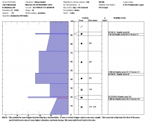
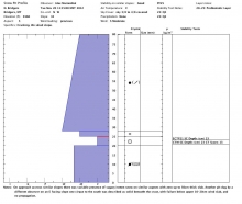
Since yesterday morning Carrot Basin Snotel site in the southern Madison Range picked up 1.4 inches of SWE (snow water equivalent) while Madison Plateau and Fisher Creek are showing close to one inch of SWE. That translates to nearly a foot of new snow. The mountains around Bozeman and Big Sky picked up 2-4 inches of snow.
At 4 am temperatures are in the teens to low 20s and winds are blowing 10-20 out of the WNW. Today, a westerly flow will keep skies partly to mostly cloudy and winds will continue to blow 10-20 out of the west. Temperatures will warm into the mid-20s to low 30s. No precipitation is expected today.


Over the past 24 hours the southern mountains picked up 4-6 inches of snow at elevations above 8,000 ft. The mountains around Bozeman and Big Sky picked up 1-2 inches. Currently, temperatures are in the high 20s to mid-30s and winds are blowing 20-30 mph out of WSW with gusts reaching close to 50 in many locations.
Today, the weather pattern will remain active as another storm moves into the region. Temperatures will remain warm with highs reaching into the upper 30s. Snow will develop late this morning and winds will stay strong out of the WSW. The southern mountains will receive the heaviest amount of snow with 8-10 inches possible by tomorrow morning. Big Sky will likely see 4-6 inches by tomorrow and the Bridgers will see 2-4 inches. Temperatures will drop this evening as a cold front moves over the area.
Since yesterday morning the southern mountains got 8-12 inches of dense new snow. The Bridger Range picked up four inches, Big Sky received one to two inches and the northern Gallatin Range got a dusting. Ridgetop winds are west to southwest at 20-30 mph, but gusting to 40 mph outside Cooke City. Mountain temperatures are in the mid to high 20s. More snow is on track for later this afternoon with another storm due Sunday. By morning the mountains will see 2-4 inches of new snow in the north and 4-6 inches in the south.
Since yesterday morning 1-2 inches of snow fell in the mountains around Cooke City and West Yellowstone; the rest of our advisory area remained dry. At 5 am temperatures are ranging from the high 20s to mid-30s and winds are blowing 20-30 mph out of the WSW with gusts reaching close to 50 mph. Today, highs will warm into the upper 30s to low 40s and winds will stay strong out of the SW. The first of a series of storms will move into southwest Montana by early afternoon. Snow will develop over the southern mountains where 4-6 inches is possible by tomorrow morning. The mountains around Bozeman and Big Sky will see 1-2 inches by tomorrow.

A moist weather system streaming off the Pacific is producing snow, mainly in our southern mountains. At 6 a.m. the mountains around Cooke City, West Yellowstone and the southern Madison Ranges have gotten 4-5 inches. Two to three inches has fallen around Big Sky, one inch in the northern Gallatins and a dusting in the Bridger Range. Winds are light at 10-15 mph out of the W to SW with temperatures in the low 20s. Another 1-2 inches will fall today, but skies will clear tonight with no further storms predicted through Wednesday.

Today is a day of thanks, and right this moment I’m thankful that it finally got cold and snowed. I know that’s pretty shallow, especially compared with family, health and life, but it’s a thanks nonetheless. The Bridger Range fared the best with seven inches of new snow. The northern Gallatin and Madison Ranges and mountains around Cooke City received 4-6 inches while the West Yellowstone area got 2-3 inches. Temperatures dropped into the low teens this morning with westerly winds blowing 20 mph with gusts to 40. Clear skies are expected through Friday as mountain temperatures reach into the high 30s and winds remain out of the west at 20-30 mph. Another system on Saturday night and Sunday should bring additional snow.
Yesterday was a beautiful sunny day with calm winds. Overnight, southerly winds increased to 20-40 mph and calmed a little this morning. A small disturbance may bring a dusting of snow tonight; otherwise, the next few days will have warm dry weather and relatively calm winds. Winds should increase Sunday ahead of an approaching cold front that will bring colder temperatures and more snow starting late Sunday.