Advisory Archive
This morning mountain temperatures are in the mid 30s to low 40s with the exception of Cooke City which is recording a cool 31 degrees F. Skies are clear and winds are blowing 15-25 mph out of the SSW with gusts in Hyalite and Big Sky reaching over 40 mph. Today, temperatures will only warm a few degrees and skies will become mostly cloudy by early afternoon as a cold front approaches from the west. Winds will continue to blow 15-30 mph from the WSW with gusts reaching close to 50 as the front approaches. Precipitation in the form of valley rain and mountain snow will move over the area by this evening. 2-4 inches of snow will likely fall above 7000 feet by tomorrow morning.

At 4 am mountain temperatures are in the mid to high 30s F with the exception of the Madison Plateau Snotel site which is recording 29 degrees F. Winds are blowing out of the SSW at 10-20 mph. Today, a southerly flow will pump warm air into southwest Montana. Daytime highs will range from the mid-40s to low 50s F. Skies will be partly cloudy in the north and mostly cloudy in the mountains around West Yellowstone and Cooke City. Winds will continue to blow 10-20 mph from the SSW.
This morning mountain temperatures are ranging between the upper 20s to low 30s F and winds are blowing 10-20 mph out of the SW. Today, temperatures will warm into the mid-forties under partly cloudy skies and winds will continue to blow 10-20 mph out of the SW.


At 4 a.m. mountain temperatures were in the mid 30s F, about 10 degrees warmer than yesterday morning. South winds were blowing 10 mph and gusting 15-30 mph. Today will have a mix of sun and clouds and a little precipitation this afternoon. South winds will continue and temperatures will be in the 40s F.
Yesterday temperatures climbed into the mid 30’s – mid 40’s F. This morning temperatures were just below freezing and winds were averaging 10-20 mph from the SW and gusting 30-40 mph. Today will have mostly sunny skies with high temperatures getting a bit warmer than yesterday. SW winds will continue with gusts of 30-40 mph.
In the last 24 hours the mountains got one inch of new snow in the northern ranges with 2-3 inches falling down south. Wind speeds increased last night from the west to southwest averaging 30 mph with gusts reaching 64 mph in Hyalite. This morning, under partly cloudy skies, temperatures are in the high teens in the south and mid-20s in the north. Today will remain partly cloudy and windy with mountain temperatures rising into the upper 30s.
Winter stopped by for a visit and left a few goodies. Yesterday’s snowfall dropped 10 inches in the Bridger Range bringing their 36-hour storm total to 18 inches. Also 10 inches fell in the northern Gallatins, 6 to 10 inches fell around Big Sky and 2-4 inches fell in the southern mountains. West to southwest winds are averaging 20 mph with gusts to 30 mph under clearing skies. This morning temperatures are a chilly 5F to 10F, but should warm to the high 20s. Today will be partly cloudy and windy with more cloud cover rolling in tonight.
AVALANCHE WARNING
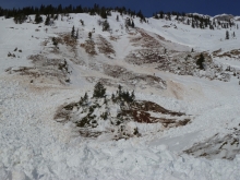
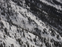
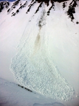
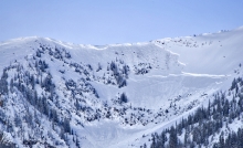
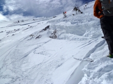
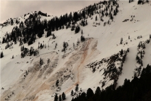
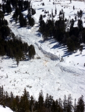
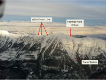
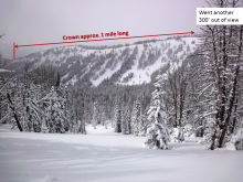
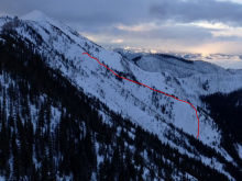
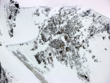
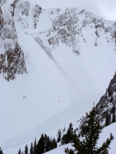
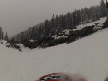
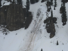
The Gallatin National Forest Avalanche Center is issuing a Backcountry Avalanche Warning for the southern Gallatin Range, southern Madison Range and Lionhead area near West Yellowstone. Heavy snowfall and strong winds are creating unstable conditions in the backcountry. Natural avalanches are currently large and destructive. The avalanche danger is rated HIGH on all slopes. Avalanche terrain including avalanche runout zones should be avoided.
Mountain Weather
Over the past 24 hours most areas picked up 4-6 inches of new snow with the exception of Cooke City which has picked 8 inches. Snow should continue through much of the day with an additional 4-6 inches falling by this evening. Currently, mountain temperatures are in the mid-teens to low twenties and winds are blowing predominately out of the west at 10-20 mph. Today, temperatures will warm into the high twenties to low thirties and winds will continue to blow out of the WNW at 10-20 mph. A ridge of high pressure will gradually build this evening and tomorrow looks to be a nice day.
Over the past 24 hours the mountains around West Yellowstone picked up 6-8 inches of high density snow; all other areas picked up 3-5 inches. Currently mountain temperatures are in the mid-twenties to low thirties and winds are blowing out of the SSW at 15-30 mph with gusts in Hyalite and Big Sky reaching close to 50 mph. Today, temperatures will warm into the mid to upper thirties and winds will continue to blow 15-30 mph out of the SSW. A moist southerly flow will produce a strong chance of mountain snow showers through the day. The southern mountains should pick up 4-6 inches by the tonight and 8-10 inches by tomorrow morning. The mountains around Bozeman and Big Sky will likely pick up 3-5 inches by tomorrow morning.
March Madness is here with more rain, snow, and above freezing temperatures. Yesterday most areas received a mix of rain and snow below 8000 ft and just snow above this elevation. The mountains near West Yellowstone and the Taylor Fork received 10 inches of heavy, dense snow, near Big Sky and Cooke City 3-5 inches, near Bozeman 2-3 inches. Temperatures this morning were hovering near freezing and winds were blowing 10-15 mph from the S with gusts of 25 mph. Hyalite was the exception with winds blowing 20-45 mph.
Today the madness continues. Temperatures should rise into the mid 30s F while some areas could see temperatures in the 40’s F. Winds will increase some but continue from the S. By tomorrow morning, another 10 inches of snow (1+ inches of SWE) will fall near West Yellowstone and the Taylor Fork, near Big Sky and Cooke City 4-6 inches of snow, and near Bozeman 2-3 inches of snow.
