Good Morning. This is Eric Knoff with the Gallatin National Forest Avalanche Advisory issued on Saturday, January 20th at 7:30 a.m. Today’s advisory is in memory of Tyler Stetson. Tyler was killed in an avalanche in Beehive Basin on this day ten years ago. This advisory does not apply to operating ski areas. The Avalanche Center has been granted an “exception” and will remain open at full capacity during the government shutdown.
AVALANCHE WARNING
The Gallatin National Forest Avalanche Center is issuing a Backcountry Avalanche Warning for the Lionhead area outside West Yellowstone. Heavy snow has fallen onto a weak and unstable snowpack. Very dangerous avalanche conditions exist and the avalanche danger is rated HIGH on all slopes. Natural and human triggered avalanches are likely. Avalanche terrain and avalanche runout zones should be avoided.
Yesterday, the mountains near West Yellowstone and Cooke City picked over a foot of new snow. The mountains around Bozeman and Big Sky picked up 4-8”. This morning, snow has moved out of the region and skies are partly cloudy. Temps range from the single digits to low teens F and winds are blowing 10-20 mph out of the W-NW. Today, a weak ridge of high pressure builds over the area producing mostly clear and calm conditions. Temps will warm into the upper teens to mid-20s F and winds will remain light to moderate out of the W-NW. No snow is expected over the next 24 hours.

Avalanche Warning
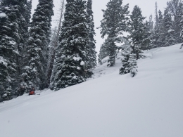
Storm totals for the Lionhead area are close to 20” totaling 2.1” of SWE. This rapid and heavy load has pushed the snowpack past its breaking point making natural and human triggered avalanches likely. Yesterday, a snowmobiler had a close call when he remotely triggered a slide in thick trees and called conditions “very sketchy” (photo). With more snow and wind since then, conditions will remain hair trigger. Slides are failing on a layer of facets buried 3-4’ deep, which is producing large and dangerous events.
Today, very dangerous avalanche conditions exist and the avalanche danger is rated HIGH on all slopes. Avalanche terrain and avalanche runout zones should be avoided.

Storm totals are impressive across the advisory area, see totals below.
- Bridger Bowl: 16” of snow totaling 1.6” of SWE.
- Shower Falls Snotel site, northern Gallatin Range: 12” of snow totaling 1.2” of SWE.
- Fisher Creek Snotel site, Cook City: 14” of snow totaling 1.5” of SWE.
- Carrot Basin Snotel site, southern Madison Range: 9” of snow totaling .9” of SWE.
- Timber weather station, Yellowstone Club: 9” of snow totaling .7” of SWE.
The government might be shutting down, but avalanches won’t be. Most avalanches occur during or immediately after a storm and today will be no exception. The main concern will be slides failing in the new snow. Wind slabs, storm slabs, and loose snow avalanches (sluffs) will all be a possibility.
Yesterday, I skied north of Bridger Bowl and got the new snow to move easily in steep terrain (video). Sluffs were moving quickly and entraining large volumes of snow, creating healthy debris piles in runout zones. Bridger Bowl Ski Patrol reported similar results during control work. Skiers in the northern Bridgers also reported touchy conditions, mainly on wind loaded slopes. Although winds calmed with the passing of the storm, fresh wind slabs will remain sensitive near upper elevation ridgelines.
Another problem to look out for will be a layer of surface hoar or near surface facets under the new snow. This layer is not widespread, but was observed on some sheltered slopes prior to the storm (photo). Look out for this problem when traveling in steep, sheltered terrain.
An additional problem will be slides failing on a layer of facets buried 2-4’ deep. This layer has been getting stronger, but still holds the potential to produce large and dangerous slides (photo). Keep an eye out for this problem in mid to low elevation terrain where the snowpack is shallower and weaker (snowpit).
Today, human triggered avalanches are likely and the avalanche danger is rated CONSIDERABLE.
If you get out and have any avalanche or snowpack observations to share, drop a line via our website, email (mtavalanche@gmail.com), phone (406-587-6984), or Instagram (#gnfacobs).
King and Queen of the Ridge
King and Queen of the Ridge, Saturday, February 3rd. A Hike and Ski/Ride-a-Thon fundraising event to support the Friends of the Gallatin National Forest Avalanche Center. Sign up and start collecting pledges HERE.
Upcoming Avalanche Education and Events
BOZEMAN
Jan. 22, MAP Brewing Pint Night, 4-8 p.m. MAP donates 50 cents of every pint sold to the Friends of the Avalanche Center.
Jan. 24, 25 and 27, Advanced Avalanche Workshop w. Field Day, Info and Register Here
Feb. 6th, Sidecountry specific avalanche awareness for family and friends. 6-8 p.m. @ Beal Park
Feb. 7th, Woman’s specific avalanche awareness, 6-7:30 p.m. @ REI in Bozeman
Feb. 7th, Avalanche awareness, 6-7:00 p.m. @ Roski Hall MSU
Feb. 9 and 10, Companion Rescue Clinic, Info and Register
March 2nd, Avalanche Awareness, 6-7:00 p.m. Bozeman Split Fest
March 7th, Avalanche Awareness, 6-7:30 p.m. @ REI
Dillion
Feb. 24th and 25th, Snowmobile intro to avalanches w/ field course. Visit mtavalanche.com/workshops/calendar for more info.
WEST YELLOWSTONE
Jan. 20, Avalanche Awareness, 7-8 p.m. at West Yellowstone Holiday Inn Conference Center
Feb. 3rd, Avalanche Awareness, 7-8 p.m. at West Yellowstone Holiday Inn Conference Center
COOKE CITY
Every Friday and Saturday, Current Conditions Update and Avalanche Rescue, Friday 6:30-7:30 p.m. at The Antler's Lodge in January. Saturday anytime between 10-2 @ Round Lake.
Our report from the snowmobiler avalanche fatality on January 10 is HERE. A snowmobiler was caught, fully buried and killed in Idaho near Reas Peak in the Centennial Range.