Good Morning. This is Eric Knoff with the Gallatin National Forest Avalanche Advisory issued on Friday, March 30th at 6:30 a.m. Today’s advisory is sponsored by Yellowstone Club Community Foundation and Spark R&D. This advisory does not apply to operating ski areas.
Over the past 24 hours the mountains picked up 1-2” of new snow. At 5 a.m. temps range from the teens to mid-20’s F and winds are blowing 15-30 mph out of W-SW. Today, highs will warm into the upper 20’s to mid-30’s F under mostly cloudy skies and increasing winds will shift to the W-NW. A weak storm moves over the area this afternoon and evening. The northern ranges including Cooke City could see 1-3” by tomorrow morning while the mountains around West Yellowstone will see a trace to 1”.

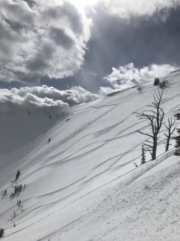
There are three avalanche problems to look out for in the backcountry today (video). The main one is wind loaded slopes. Earlier in the week, fresh snow combined with strong winds created unstable wind slabs (video, photo). Over the past few days, wind slabs have trended towards stability. Yesterday, I ventured south of Bridger Bowl and found wind loaded slopes to be stubborn and well bonded. Doug found similar conditions in Hyalite. Although the likelihood of triggering wind slabs is decreasing, it cannot be ruled out (photo, photo). Today, keep your avalanche radar on and be cautious around wind loaded slopes, especially those associated with high consequence terrain.
Our secondary problem is cornices (photo). The likelihood of being involved with a natural cornice failure is rather low, but it’s best to limit time on slopes directly below these bus sized chunks of snow (photo). A more likely scenario is triggering a cornice along the ridgeline and tumbling over the edge. This problem can be easily avoided by giving cornices a wide berth along the ridgelines.
Our final problem is wet snow avalanches. This time of year, it only takes a short period of direct sun or above freezing temps to create a wet snow avalanche hazard. I don’t expect this to be a major problem today with increasing clouds, strong winds and cooler temps, but it’s always something to keep an eye out for in springtime.
Today, natural avalanches are unlikely, but human triggered avalanches are possible on wind loaded slopes which have a MODERATE avalanche danger. Generally stable conditions exist on non-wind loaded slopes which have a LOW avalanche danger.
If you get out and have any avalanche or snowpack observations to share, drop a line via our website, email (mtavalanche@gmail.com), phone (406-587-6984), or Instagram (#gnfacobs).
Send us your observations on Instagram! #gnfacobs
Posting your snowpack and avalanche observations on Instagram (#gnfacobs) is a great way to share information with us and everyone else this spring.