Good Morning and Happy Easter. This is Alex Marienthal with the Gallatin National Forest Avalanche Advisory issued on Sunday, April 1st at 6:45 a.m. Today’s advisory is sponsored by Yellowstone Club Community Foundation and Beartooth Powder Guides. This advisory does not apply to operating ski areas. Hyalite Canyon road is closed to vehicles today and will re-open in six weeks (not fooling).
Yesterday morning, the Bridger Range got 7” of cold, low density new snow while the rest of the advisory area did not get any. Temperatures this morning are teens to low 20s F and wind is west-northwest at 5-15 mph with gusts to 25 mph. This morning will be partly sunny and cloud cover will increase through today. Temperatures will be 20s to low 30s F with west-southwest wind at 20-30 mph this afternoon. A warm spring storm is expected overnight and tomorrow, and the mountains will get 3-5” of snow by morning and 4-7” tomorrow.

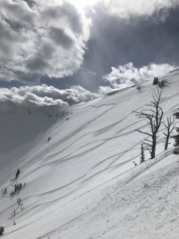
The Bridger Range got 7” of new snow equal to .2” of snow water equivalent yesterday morning. Light to moderate westerly wind drifted this light powder into slabs that are possible to trigger today. These soft wind slabs are 6-12” thick and mostly found near ridgelines. Small avalanches of new snow are also possible on steep slopes, and wet loose avalanches are possible if the sun shines this morning. Avalanches in the new snow will probably be small today, and deeper avalanches are not likely.
Small wet loose avalanches and wind slabs can be deadly if they carry a person over cliffs or into trees, and a long ride in lower consequence terrain can still be harmful. Avoid wind loaded slopes if you see cracking of fresh drifts. Choose lower angle or lower consequence terrain if the snow surface gets moist or if you see dry or wet loose avalanches. Today, avalanches are possible to trigger and avalanche danger is MODERATE.

The mountains near Big Sky, West Yellowstone and Cooke City did not get any snow in the last 24 hours, and wind has been light to moderate out of the west-northwest. Strong westerly wind on Friday created fresh, 1-2 foot thick drifts that were easy to trigger. My partner and I were able to trigger these wind slabs near Cooke City on Friday, and we saw one that broke naturally (video, photo). Yesterday these slabs were less reactive and today they are difficult to trigger, but not entirely ruled out. Heavily wind loaded slopes, such as those near prominent ridgelines and below huge cornices, should be approached with caution.
Cornices are massive and dangerous (photo). They can fail under the weight of a person. Give them a wide distance along ridgelines and minimize time on slopes below. If the sun shines this morning, wet loose avalanches are possible on steep, sun exposed slopes. They will likely be small, but are something to keep an eye out for before clouds set in this afternoon. Today, avalanches are not likely or will be very small. Avalanche danger is rated LOW.
If you get out and have any avalanche or snowpack observations to share, drop a line via our website, email (mtavalanche@gmail.com), phone (406-587-6984), or Instagram (#gnfacobs).
Send us your observations on Instagram! #gnfacobs
Posting your snowpack and avalanche observations on Instagram (#gnfacobs) is a great way to share information with us and everyone else this spring.