Good Morning. This is Doug Chabot with the Gallatin National Forest Avalanche Forecast issued on Tuesday, December 18th at 7:15 a.m. Today’s forecast is sponsored by Grizzly Outfitters in partnership with the Friends of the Avalanche Center. This forecast does not apply to operating ski areas.
At 6 a.m. an inch of snow has fallen in the mountains outside West Yellowstone and Cooke City. Temperatures are in the low to high 20s and winds are southwest at 15-20 mph with gusts of 40 mph. Today, snowfall and wind will continue around West Yellowstone and Cooke City. By tomorrow morning these mountains will have 4-6” of snow with 1-2” elsewhere. Temperatures will remain in the 20s and wind will increase from the southwest.

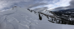
Weak and shallow snow define the Lionhead area. The snowpack is 2’ deep and the bottom foot consists of weak, sugary grains that will quickly become unstable from the weight of new snow. Eric shows us these facets draining out of the pit wall in last week’s video. Wind-loaded slopes are the most susceptible to being triggered, but if the storm lays down a heavy blanket of snow all slopes will be suspect. Snowfall and wind are on the menu today, and the avalanche danger will rise. This morning it is rated MODERATE, but could increase to CONSIDERABLE by day’s end.
Avalanches are still occurring. Yesterday a skier triggered a large slide on a wind-loaded slope on a NE aspect of Bridger Peak. The slide broke up to a foot deep and ran 100’ wide and 2,000’ vertical. It was triggered with a ski cut that broke on a weak layer of facets that formed during the cold, clear weather 12 days ago. No one was caught and the skier shared pictures, a video, and details of the avalanche. This is the same layer that collapsed with a loud “whumph” on Eric and Alex on the west side of the range on Saturday (video, photo, details).
A weak layer of faceted snow is buried 6-18” under the surface in all our mountain ranges, but not necessarily on every slope. Avalanches are occurring on this layer which is outlined in our Weather and Avalanche Log. Since December 10th there have been 16 avalanches reported, all involving wind-drifted snow, and 8 of these were human triggered. Some were small slides and a couple were large, including a snowmobiler triggered slide on Buck Ridge that Alex and I investigated Sunday (video, photo).
Outside Cooke City a few avalanches were reported since Saturday: two wind slabs naturally released (photo, photo), and a snowbike triggered a small wind pillow next to a road (photo). Guides are reporting the snowpack is getting weaker and an overall concern that widespread avalanches are on the horizon once the firehose of snow gets turned on.
Today, avalanches are possible on wind loaded slopes which have a MODERATE avalanche danger. On non-wind loaded slopes avalanche danger is LOW. Wind-loaded slopes should be assessed or avoided.
If you get out and have any avalanche or snowpack observations to share, contact us via our website, email (mtavalanche@gmail.com), phone (406-587-6984), or Instagram (#gnfacobs).
Upcoming Avalanche Education and Events
Our education calendar is full of awareness lectures and field courses. Check it out: Events and Education Calendar.
BOZEMAN
January 2, Avalanche Awareness, 6-7:30 p.m. at REI, Bozeman. Pre-register at https://www.rei.com/events.
January 8, Women’s Specific Avalanche Awareness, 6:30-8 p.m. Story Mill Park, Bozeman.
January 9, 1-hr Avalanche Awareness, 7-8 p.m. Spire Climbing Center, Bozeman.
COOKE CITY
Every Friday and Saturday, Rescue Training and Snowpack Update. Friday 6:30-7:30 p.m. at the Soda Butte Lodge. Saturday anytime between 10-2 @ Round Lake.
Check out our new “Avalanches and Snowpits” menu item where we list all the reported avalanche activity.