Good Morning. This is Doug Chabot with the Gallatin National Forest Avalanche Forecast issued on Wednesday, December 19th at 7:00 a.m. Today’s forecast is sponsored by Mystery Ranch and Spark R&D. This forecast does not apply to operating ski areas.
At 5 a.m. snowfall is tapering. Mountain totals are 2-3” at SNOTEL sites in the Bridger and northern Gallatin Ranges and 5-6” elsewhere. Winds are blowing strong out of the west to northwest and will remain so today. Average speeds are 25-30 mph with gusts of 50-60 mph. Mountain temperatures are in the high teens to low 20s F this morning. Today will turn partly cloudy and remain cool, with the next possible snow falling Friday.

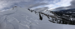
The Lionhead area outside West Yellowstone received 6” of snow (.4” of snow water equivalent) with strong westerly winds. The snow fell onto a weak snowpack. Yesterday my partner and I rode and skied into this area and found a 2-2.5’ deep snowpack with two distinct weak layers breaking in our tests (video). The most worrisome consists of loose, sugary facets at the bottom half of the snowpack. The second is a layer of small facets a few inches under the surface. Either of these are unstable enough to avalanche, especially on slopes with a wind-load. Triggering an avalanche is likely today. Collapsing and shooting cracks are warning signs to stick to low-angled terrain. Given the new snow and strong wind the avalanche danger is rated CONSIDERABLE on all slopes.
Snowfall totals range from 2” inches at Brackett Creek in the northern Bridger mountains (a trace at Bridger Bowl), to 3” in Hyalite and 5-6” around Big Sky and Cooke City. The snow water equivalent is .3-.6”, enough weight to tip wind-loaded slopes toward instability. Last night the wind started to blow strong from the west to northwest and today there will be many thick and dense wind slabs ready to avalanche.
In the days leading up to this storm avalanches were being triggered on wind-loaded slopes throughout our forecast area. The two most recent and largest was a skier triggered slide on Bridger Peak on Monday (photo, video, details) and a snowmobiler triggered slide on Buck Ridge on Sunday (photo, video, details). Others include natural slides outside Cooke City (photo) and in the southern Madison Range (photo). These avalanches were wind-loaded and broke on a weak layer of facets that formed during the cold, clear weather earlier in the month. With today’s new snow and strong wind, this layer will be under strain and triggering avalanches is likely. Avoid wind-loaded slopes. Today, the avalanche danger is rated CONSIDERABLE on all wind-loaded slopes and MODERATE on all others.
Take a look at the Weather and Avalanche Log to get a handle on the recent activity, and also check out our videos to better understand the snowpack.
If you get out and have any avalanche or snowpack observations to share, contact us via our website, email (mtavalanche@gmail.com), phone (406-587-6984), or Instagram (#gnfacobs).
Upcoming Avalanche Education and Events
Our education calendar is full of awareness lectures and field courses. Check it out: Events and Education Calendar.
BOZEMAN
January 2, Avalanche Awareness, 6-7:30 p.m. at REI, Bozeman. Pre-register at https://www.rei.com/events.
January 8, Women’s Specific Avalanche Awareness, 6:30-8 p.m. Story Mill Park, Bozeman.
January 9, 1-hr Avalanche Awareness, 7-8 p.m. Spire Climbing Center, Bozeman.
COOKE CITY
Every Friday and Saturday, Rescue Training and Snowpack Update. Friday 6:30-7:30 p.m. at the Soda Butte Lodge. Saturday anytime between 10-2 @ Round Lake.
Check out our new “Avalanches and Snowpits” menu item where we list all the reported avalanche activity.