Good Morning. This is Alex Marienthal with the Gallatin National Forest Avalanche Forecast issued on Christmas Eve, Monday, December 24th at 7:00 a.m. Today’s forecast is sponsored by Grizzly Outfitters and The Friends of the Avalanche Center. This forecast does not apply to operating ski areas.
Over the last 24 hours the mountains got a trace to 1” of snow and wind was west to southwest at 15-25 mph. This morning, temperatures are low teens to low 20s F and will be high teens to low 20s F today. Wind will be westerly at 15-25 mph today. A quick storm this morning could drop 3-5” of snow in the Bridger Range and Cooke City with 2-4” elsewhere. This afternoon and tonight will be partly cloudy with another round of light snow tomorrow afternoon.

In the mountains near West Yellowstone and the southern Madison and Gallatin Ranges the lower half of the snowpack is weak, sugary facets. Eric found this weak snowpack last week near Bacon Rind in the southern Madison Range (video) and Doug saw it near West Yellowstone (video). Recent snow and wind have formed unstable slabs of snow on top of this weak foundation. On Saturday, Skiers at Bacon Rind heard three “whumphs” when they collapsed the unstable snowpack in low angle meadows (details).
A few inches of snow this morning will get drifted into fresh slabs and add weight to the unstable snowpack. Slopes will be most unstable during new snow and wind loading. Be extra cautious of steep, freshly wind loaded slopes today. Avoid steep slopes if they have a thick slab of snow resting on weak, sugary facets. Today, avalanches are possible to trigger and avalanche danger is MODERATE.
The mountains near Bozeman, Big Sky and Cooke City have a 2-4’ deep and mostly stable snowpack. The exception is slopes where recent snow was drifted into thick slabs over a weak layer of facets or surface hoar buried 8-12” deep. Minimal recent snow and wind loading makes these slabs more difficult to trigger, but it remains possible. A few inches of new snow this morning will be drifted into fresh wind slabs that will be easy to trigger. These fresh slabs will likely be small and add relatively little stress to a generally strong snowpack.
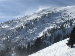
Carefully assess wind loaded slopes today and consider the consequences of even small slides. Yesterday, Doug and I went to Saddle Peak and found a mostly strong snowpack, but there were hard wind slabs on the surface scattered around the mountain (video). Eric and my recent videos from near Big Sky and Cooke City also show the main instabilities are in the top 8-12” of an otherwise generally strong snowpack. Today, it is possible to trigger small wind slabs and avalanches on facets 8-12” deep, and avalanches deeper than that are unlikely. Avalanche danger is MODERATE on wind loaded slopes and LOW on non-wind loaded slopes.
If you get out and have any avalanche or snowpack observations to share, contact us via our website, email (mtavalanche@gmail.com), phone (406-587-6984), or Instagram (#gnfacobs).
Snowmobiler Avalanche Fatality in the Wyoming Range, Wyoming
From Bridger-Teton Avalanche Center (12/24): “A snowmobiler died two days ago in the Wyoming Range after triggering a small slab avalanche and getting pinned beneath his sled.” Check the BTNFAC website or avalanche.org for updated details. Our condolences go out to those involved.
Upcoming Avalanche Education and Events
Our education calendar is full of awareness lectures and field courses. Check it out: Events and Education Calendar.
BOZEMAN
January 2, Avalanche Awareness, 6-7:30 p.m. at REI, Bozeman. Pre-register at https://www.rei.com/events.
January 8, Women’s Specific Avalanche Awareness, 6:30-8 p.m. Story Mill Park, Bozeman.
January 9, 1-hr Avalanche Awareness, 7-8 p.m. Spire Climbing Center, Bozeman.
WEST YELLOWSTONE
January 12 and 26, 1-hr Avalanche Awareness for Snowmobilers, 7-8 p.m. Holiday Inn West Yellowstone.
COOKE CITY
Every Friday and Saturday, Rescue Training and Snowpack Update. Friday 6:30-7:30 p.m. at the Soda Butte Lodge. Saturday anytime between 10-2 @ Round Lake.
See Alex’s recent article about the Lift-accessed Backcountry of Saddle Peak. Be prepared with the necessary knowledge and skills before leaving the ski area into this complex and deadly terrain.