Good morning. This is Eric Knoff with the Gallatin National Forest Avalanche Forecast issued on Friday, December 27th at 7:15 a.m. Today’s forecast is sponsored by Yellowstone Arctic Yamaha and the Friends of the Avalanche Center. This forecast does not apply to operating ski areas.
Over the past 24 hours the Bridger Range picked up 4-6” of new snow. The rest of the forecast area picked up 1-2”. This morning, it’s still snowing lightly in the Bridger Range and dry elsewhere. Temps range from the single digits above or below zero F and winds are blowing 5-20 mph out of the west-northwest. Today, skies will start cloudy but become increasing clear by this afternoon. Temps warm into the teens F and winds will remain light to moderate out of the west-northwest. No accumulation is expected today or tonight, but more snow arrives tomorrow and Sunday.

The snowpack depth in the mountains near West Yellowstone and south of Big Sky is below average. In most locations, the pack is 2-3’ deep and consists of sugary facets near the ground. This persistent weak layer is widespread and continues to be our main avalanche concern.
Human triggered avalanches remain possible, primarily on slopes where older slabs of wind deposited snow rest over the weak faceted foundation. The best defense against a pervasive weak layer problem is careful terrain management. It’s best to keep slope angles less than 30 degrees and avoid recreating on slopes attached to steep slopes above. If you do travel into avalanche terrain, carry the proper rescue gear, only expose one person at a time to steep slopes, and always watch your partner from a safe location.
Today, a poor snowpack structure makes all steep slopes susceptible to human triggered avalanches and the avalanche danger is rated MODERATE.
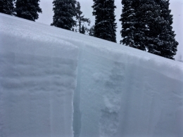
The snowpack is highly variable in the mountains around Cooke City. North of town, a layer of facets 1-1.5’ below the surface is the main avalanche concern. Doug found this layer to be reactive in stability tests on Wednesday (video, photo). The tricky part about this layer is it does not exist on every slope and has not been overly reactive. The only way to assess the strength and distribution of this weak layer is dig a snowpit and do a stability test. If test results point to instability, stick to lower angle terrain or find a slope with a stronger structure.
South of town, the snowpack is shallower and weaker. Yesterday, Doug toured up Republic Creek and found facets in the lower portion of the pack to be his main concern. This weak layer is not under a lot of stress without new snow and wind, but will be problematic with the next significant loading event.
Today, buried weak layers make human triggered avalanches possible and the avalanche danger is rated MODERATE.
Over the past 24 hours, the Bridger Range picked up 4-6” of low density snow (cold smoke). This did not add a lot of weight/stress to the snowpack, but it did create new snow instabilities. Yesterday, Alex toured on the Throne in the northern Bridgers and found loose dry avalanches (sluffs) and soft wind slabs to be the main avalanche problems (video, photo). Today, sluffs and soft slabs will be possible to trigger on all steep slopes. For this reason, the avalanche danger is rated MODERATE in the Bridger Range.
The northern Gallatin (Hyalite) and northern Madison (Big Sky) Ranges picked up 1-2” of snow the past few days. This new snow has been pushed around by west-northwest winds in upper elevation terrain. As a result, small wind slabs have formed in isolated areas. These fresh slabs won’t be exceptionally large, but could catch you off guard if you’re not paying attention. Be especially aware of this problem if you’re skiing or riding in steep, high consequence terrain. Aside from isolated wind slabs, the snowpack is generally stable (video).
Today, human triggered avalanches are possible on wind loaded slopes which have a MODERATE avalanche danger. Non-wind loaded slopes have a LOW avalanche danger.
If you get out and have any avalanche or snowpack observations to share, contact us via our website, email (mtavalanche@gmail.com), phone (406-587-6984), or Instagram (#gnfacobs).
New webpage dedicated to the Centennial Range in Idaho and Montana
After last season's two snowmobiler avalanche fatalities on Reas Peak in the Centennial Range we created a webpage so riders could get good, relevant information regarding snowpack and avalanches. Although the Centennial Range is not part of the Gallatin National Forest Avalanche Center's forecast area, we are the closest avalanche center and have valuable information to share. More…
Upcoming Avalanche Education and Events
Our education calendar is full of awareness lectures and field courses. Check it out: Events and Education Calendar.
BOZEMAN
January 2, Avalanche Awareness, 6-7:30 p.m. at REI, Bozeman. Pre-register at https://www.rei.com/events.
January 8, Women’s Specific Avalanche Awareness, 6:30-8 p.m. Story Mill Park, Bozeman.
January 9, 1-hr Avalanche Awareness, 7-8 p.m. Spire Climbing Center, Bozeman.
WEST YELLOWSTONE
January 12 and 26, 1-hr Avalanche Awareness for Snowmobilers, 7-8 p.m. Holiday Inn West Yellowstone.
COOKE CITY
Every Friday and Saturday, Rescue Training and Snowpack Update. Friday 6:30-7:30 p.m. at the Soda Butte Lodge. Saturday anytime between 10-2 @ Round Lake.
See Alex’s recent article about the Lift-accessed Backcountry of Saddle Peak. Be prepared with the necessary knowledge and skills before leaving the ski area into this complex and deadly terrain.