Good morning. This is Eric Knoff with the Gallatin National Forest Avalanche Forecast issued on Thursday, December 27th at 7:15 a.m. Today’s forecast is sponsored by Knoff Group Real Estate and Community Food Co-op. This forecast does not apply to operating ski areas.
Yesterday, the Bridger Range picked up 3” of new snow while the rest of the forecast area picked up a trace to one inch. This morning, temps are in the single digits F and winds are blowing 5-15 mph out of west-northwest. Today, temps warm into the teens under cloudy skies. The mountains could see one inch of snow by this afternoon. Winds remain light to moderate out of the west-northwest. No significant accumulation is expected tonight or tomorrow.

In the mountains south of Big Sky and near West Yellowstone, the snowpack is weak but not highly unstable. Without a recent loading event, facets near the ground are not overly stressed. The last reported activity was audible collapsing at Bacon Rind in the southern Madison Range on the 22nd of December (details). Similar activity was reported south of our forecast area in the Centennial Range on the 23rd (details).
Avalanches are becoming less likely without new snow and wind. However, a poor snowpack structure continues to make slides possible. Slopes with wind drifted snow are the most likely to produce unstable conditions. Since weak facets near the ground exist on all aspects and elevations, it’s important to pay attention to surface conditions on the slope you want to ski or ride. If the snow feels firm, punchy, slabby, or all the above, stay off steep slopes and move to more sheltered terrain. The avalanche fatality south of Jackson Hole earlier in the week is a sobering reminder it only takes a small slide to create a potentially deadly situation (accident report).
Today, a poor snowpack structure makes all steep slopes susceptible to human triggered avalanches. For this reason the avalanche danger is rated MODERATE.
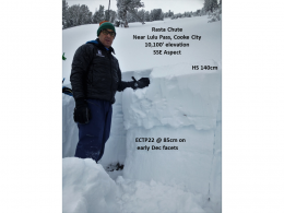
In the past week, the mountains around Cooke City have picked up over a foot of snow totaling more than 1.5” of SWE (snow water equivalent). This incremental load is adding stress to a layer of facets buried 1-2’ feet deep. This weak layer formed in early December and exists on all aspects and elevations. Yesterday, Doug found this layer to be reactive in stability tests near Lulu Pass (video, photo). This is consistent with Alex’s observations from last week (video).
Slopes with wind drifted snow will be the most likely to hold unstable conditions, but non-wind loaded slopes also hold the potential to produce slides. Today, carefully evaluate the snowpack before committing to avalanche terrain and always be thinking about the consequences of triggering a slide.
Today, human triggered avalanches are possible on all steep slopes and the avalanche danger is rated MODERATE.
In the mountains around Bozeman and Big Sky, the snowpack is generally strong and stable (video). Yesterday, I skied Divide Peak in Hyalite and observed no signs of instability (video). I did find 6-8” of low density snow that will easily be transported by light to moderate winds.
Today, wind loaded slopes are the main avalanche concern. Watch for soft wind drifts on slopes loaded by west-northwest winds. These drifts will be relatively small in size, but could catch and carry a skier or rider into unfavorable terrain. Most avalanches will stay confined to the new snow, but slides breaking on facets buried 1-1.5’ deep are also possible. This layer continues to produce unstable test results on slopes with thick slabs of wind drifted snow. Although this layer is not highly reactive, it’s worth assessing before riding steep terrain.
Today, human triggered avalanches are possible on wind loaded slopes which have a MODERATE avalanche danger. Non-wind loaded slopes have a LOW avalanche danger.
If you get out and have any avalanche or snowpack observations to share, contact us via our website, email (mtavalanche@gmail.com), phone (406-587-6984), or Instagram (#gnfacobs).
New webpage dedicated to the Centennial Range in Idaho and Montana
After last season's two snowmobiler avalanche fatalities on Reas Peak in the Centennial Range we created a webpage so riders could get good, relevant information regarding snowpack and avalanches. Although the Centennial Range is not part of the Gallatin National Forest Avalanche Center's forecast area, we are the closest avalanche center and have valuable information to share. More…
Upcoming Avalanche Education and Events
Our education calendar is full of awareness lectures and field courses. Check it out: Events and Education Calendar.
BOZEMAN
January 2, Avalanche Awareness, 6-7:30 p.m. at REI, Bozeman. Pre-register at https://www.rei.com/events.
January 8, Women’s Specific Avalanche Awareness, 6:30-8 p.m. Story Mill Park, Bozeman.
January 9, 1-hr Avalanche Awareness, 7-8 p.m. Spire Climbing Center, Bozeman.
WEST YELLOWSTONE
January 12 and 26, 1-hr Avalanche Awareness for Snowmobilers, 7-8 p.m. Holiday Inn West Yellowstone.
COOKE CITY
Every Friday and Saturday, Rescue Training and Snowpack Update. Friday 6:30-7:30 p.m. at the Soda Butte Lodge. Saturday anytime between 10-2 @ Round Lake.
See Alex’s recent article about the Lift-accessed Backcountry of Saddle Peak. Be prepared with the necessary knowledge and skills before leaving the ski area into this complex and deadly terrain.