Good morning. This is Doug Chabot with the Gallatin National Forest Avalanche Forecast issued on Wednesday, December 26th at 7:15 a.m. Today’s forecast is sponsored by Cooke City Super 8/Bearclaw Bob’s and Werner Wealth Management. This forecast does not apply to operating ski areas.
In the last 24 hours the mountains picked up 2-3” of new snow with the northern Gallatin getting 5”. Currently, mountain temperatures are 5-10F and winds are west to northwest at 10-20 mph. Skies will clear this morning, temperatures will rise to 20F and drop into the single digits tonight, and westerly winds will blow 15-25 mph at the ridgetops. No new snow is expected in the next 24 hours.

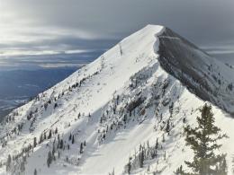
In the mountains from Big Sky to West Yellowstone, the snowpack is weak. The bottom half consists of sugary facets that do not have much structural integrity. These weak grains are easily scooped out of the snowpit wall and do not instill confidence in their ability to support a big snowfall. Videos from our field days to Bacon Rind and Lionhead illustrate this well. On Saturday, a skier in Bacon Rind got three distinct “whumphs” when the snow collapsed under his weight (details). This is a clear sign of instability. On Monday, a skier found a very similar snowpack on Emigrant Peak in Paradise Valley (outside our forecast area) and triggered a large avalanche (details). Yesterday’s 2-3” of snow (.2” snow water equivalent or SWE) will be drifted at the ridgelines from westerly winds, loading slopes even more. For today, stay off of wind-loaded slopes and avoid avalanche terrain if you experience collapsing. Triggering avalanches is possible and the danger is rated MODERATE on all slopes.
Snowfall in the last 24 hours were 2-5” around Bozeman, Big Sky and Cooke City. Winds are blowing westerly with gusts of 20 mph and this new snow will be easily blown into drifts. The snowpack in these mountains has a weak layer of facets and surface hoar buried about a foot under the surface. On some slopes this unstable layer is capped by wind-drifted snow which we chronicle in our videos from Saddle Peak, Beehive Basin, and Cooke City.
Snowmobilers on Friday triggered a few small slides near Lulu Pass outside Cooke City (details) and on Saturday a sledder triggered a small slide on Buck Ridge south of Big Sky (details). In the last five days the snowpack has been incrementally loaded with new snow measuring 1.1” of SWE in Cooke City and .6-.8” of SWE elsewhere (Weather Log). This snow is being blown into drifts and creates the possibility of triggering avalanches. For today, the avalanche danger is rated MODERATE on all wind-loaded slopes and LOW on all others.
If you get out and have any avalanche or snowpack observations to share, contact us via our website, email (mtavalanche@gmail.com), phone (406-587-6984), or Instagram (#gnfacobs).
New webpage dedicated to the Centennial Range in Idaho and Montana
After last season's two snowmobiler avalanche fatalities on Reas Peak in the Centennial Range we created a webpage so riders could get good, relevant information regarding snowpack and avalanches. Although the Centennial Range is not part of the Gallatin National Forest Avalanche Center's forecast area, we are the closest avalanche center and have valuable information to share. More…
Upcoming Avalanche Education and Events
Our education calendar is full of awareness lectures and field courses. Check it out: Events and Education Calendar.
BOZEMAN
January 2, Avalanche Awareness, 6-7:30 p.m. at REI, Bozeman. Pre-register at https://www.rei.com/events.
January 8, Women’s Specific Avalanche Awareness, 6:30-8 p.m. Story Mill Park, Bozeman.
January 9, 1-hr Avalanche Awareness, 7-8 p.m. Spire Climbing Center, Bozeman.
WEST YELLOWSTONE
January 12 and 26, 1-hr Avalanche Awareness for Snowmobilers, 7-8 p.m. Holiday Inn West Yellowstone.
COOKE CITY
Every Friday and Saturday, Rescue Training and Snowpack Update. Friday 6:30-7:30 p.m. at the Soda Butte Lodge. Saturday anytime between 10-2 @ Round Lake.
See Alex’s recent article about the Lift-accessed Backcountry of Saddle Peak. Be prepared with the necessary knowledge and skills before leaving the ski area into this complex and deadly terrain.