Good Morning. This is Doug Chabot with the Gallatin National Forest Avalanche Forecast on Wednesday, February 17th at 7:30 a.m. Today's forecast is sponsored by Uphill Pursuits and Ph.D. Skis. This forecast does not apply to operating ski areas.
AVALANCHE WARNING
The Gallatin National Forest Avalanche Center is issuing a Backcountry Avalanche Warning for the Bridger, northern Gallatin and northern Madison Ranges. At least 20-30 inches of snow has fallen in the last few days with westerly wind. The weight of the new snow is overloading a weak snowpack and creating very dangerous avalanche conditions. Natural and human triggered avalanches are likely. Avalanche terrain and avalanche runout zones should be avoided. The avalanche danger is rated HIGH on all slopes. Contact the Gallatin National Forest Avalanche Center for more detailed information.
This warning will expire or be updated by 6:00 a.m. on Thursday, February 18, 2021.
BEEHIVE BASIN AVALANCHE ACCIDENT REPORT
We posted a detailed report from Sunday's fatal avalanche in Beehive Basin here.
The video of our accident investigation from the field is here.
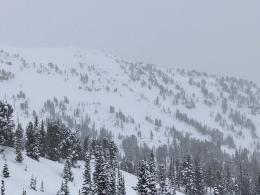
At 5 a.m. it is still snowing, but will taper off today. In the last 24 hours 8-12” fell in the Bridger, northern Gallatin and northern Madison Ranges and 2-4” everywhere else. With temperatures in the single digits wind is from the west to northwest at 15 mph with gusts of 25-30 mph. Wind will continue today and snowfall will end this morning with another 3-5” expected around Bozeman and Big Sky and 2-3” around West Yellowstone and Cooke City.

Avalanche Warning
We issued an Avalanche Warning for the Bridger, northern Madison and northern Gallatin Ranges. The snow is piling up and adding weight to a weak snowpack. Weather stations are showing 20-30” of snow since early Monday measuring 2.2” of snow water equivalent-SWE in the Bridger Range and 1.4” SWE in Big Sky and Hyalite (1” SWE in last 24 hours). Reports from ski patrols indicate high snowfall rates. Big Sky Ski Patrol measured 3” of snow falling in an hour after they closed, something the weather stations did not pick up on. I’m nervous because even though the snowfall/SWE numbers may not seem like much, reports from the field indicate otherwise. We have a weak snowpack with sugary facets near the ground. On Sunday a splitboarder died from injuries he sustained in an avalanche in Beehive Basin. Last week two snowmobilers got very lucky when they were not caught after triggering a large avalanche in Portal Creek, and skiers saw large avalanches on Divide Peak in Hyalite.
A big snowstorm makes big avalanches. Our mountains have a weak snow structure and recent avalanche activity means we should expect more avalanches today. The danger is rated HIGH on all slopes. Stay away from all avalanche terrain including runout zones.

The southern Madison and southern Gallatin Ranges got another 4” of snow yesterday bringing their storm total to 15”, measured as 1.2” of SWE. The snowpack structure is weak with sugary facets at the bottom of the snowpack that can avalanche. The new snow will also be unstable at the interface of the new/old snow a foot under the surface. Wind-loading from west-northwest wind will further increase the load at the ridgelines and starting zones. Ian was in Teepee Basin last week and saw avalanches (video), and a rider was caught in a slide in Cabin Creek on Saturday. All this snowfall is creating dangerous avalanche conditions. Triggering slides, potentially large and deadly ones, is likely. Today is a day to stay out of avalanche terrain because the danger is rated CONSIDERABLE on all slopes.

The mountains around Cooke City and West Yellowstone have not had a big snowstorm, but they are getting incremental loading and wind. In the last 3 days 9” of snow has fallen measuring .6-.7” of SWE. Winds was strong from the west to northwest Monday and Tuesday, but is dying down today. The major concern are wind-loaded slopes and slopes that have facets near the ground. Facets are found on most slopes in Lionhead and in thin areas (less than 4 feet deep) around Cooke City. Recent avalanche activity, even on small slopes, is a sign of instability (video). Dig, test and be cautious traveling in avalanche terrain, especially where the snowpack is thin and wind-loaded which I explain in this video from the weekend. For today the avalanche danger is rated MODERATE on all slopes.
If you get out, please send us your observations no matter how brief. You can submit them via our website, email (mtavalanche@gmail.com), phone (406-587-6984), or Instagram (#gnfacobs).
Upcoming Avalanche Education and Events
See our education calendar for an up-to-date list of all local classes. Here are a few select upcoming events and opportunities to check out:
Every Saturday in Cooke City, FREE snowpack update and rescue practice at the Round Lake Warming Hut between 10 a.m. and 3 p.m. Poster with More Info.
February 22, 6-7 p.m., Forecaster Chat: Rethinking Avalanche Terrain from a Strategic Perspective, Hosted online by Uphill Pursuits, Link to Join HERE
Here’s an AP article that quotes Dave Zinn about the snowpack and avalanches that have been occurring.