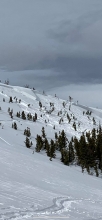
All Avalanche Incidents for Advisory Year 2018-19
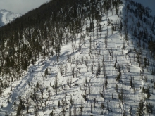
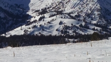
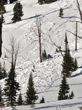
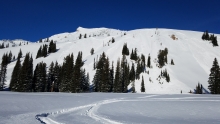
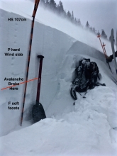
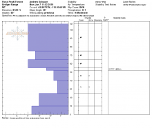
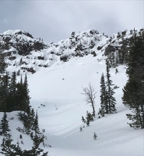
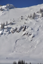
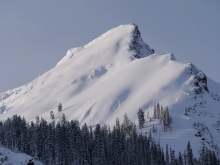
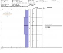
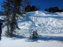
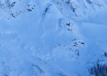
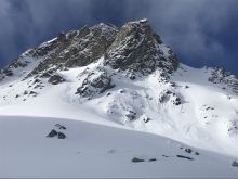
HS-AEc-R4-D3.5-G
Coordinates: 45.2780, -111.4500
Caught: 0 ; Buried: 0; Killed: 0
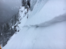
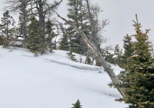
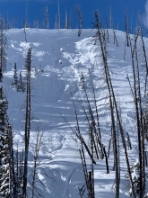
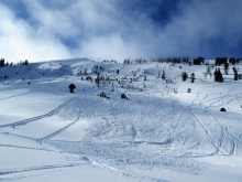
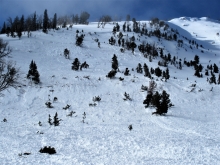
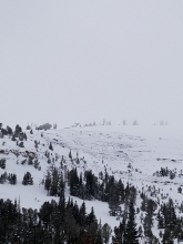
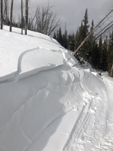
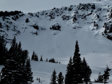
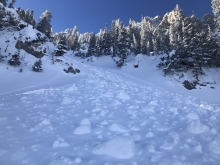
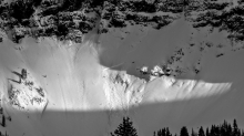
Big Sky Ski Patrol triggered a large deep slab avalanche during control work this morning, with a crown depth up to 10 feet deep. From the e-mail: "This is generally one of our most heavily wind loaded areas on the mountain with any wind with a westerly component. It ran on a combo of ground and an ice crust that was sitting in a recessed area, probably leftover October snow. Crown depth ranged from 10’ near the cornice but quickly tapered to an average of 3-5’." -BSSP
More Avalanche Details
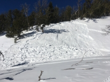
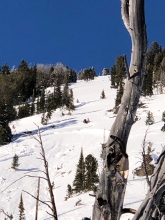
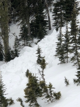
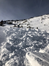
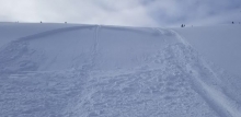
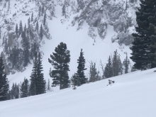
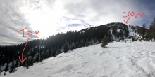
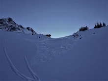
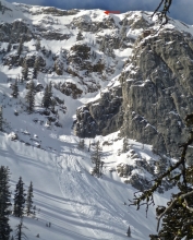
SS
Caught: 0 ; Buried: 0
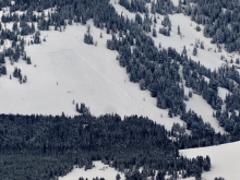
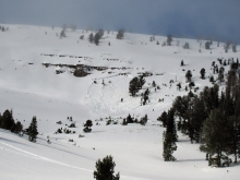
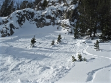
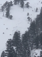
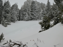
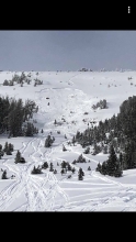
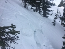
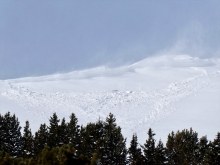
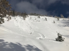
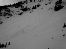
This slide was observed by skiers near the south boundary of Bridger Bowl. The slide ran over the south end of the cliffs into the Going Home Chute. It was described as a natural by the patrol, but it could have been human triggered.
More Avalanche Details
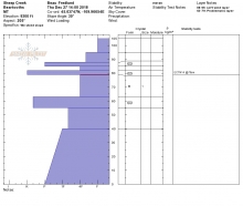
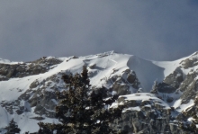
SS-ASu-R4-D3-O
Elevation: 9,000
Aspect: E
Coordinates: 45.5422, -111.9980
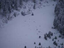
Caught: 4 ; Killed: 1
Four skiers were ascending a steep, heavily treed slope and triggered a large avalanche. The two skiers highest on the slope grabbed trees, and the lower two were caught and partially buried. One died from trauma at the site, and the other was air-lifted to emergency care with serious injuries. (A more detailed accident report will be available soon. Check back in a day or two.) Our deepest condolences go out the family and friends of the victim.
More Avalanche Details


Caught: 0 ; Buried: 0
"Cracking/Whumphing observed on open east aspect at ~7300' in the main fork of Hyalite Canyon. We also observed what we suspect was a powder cloud across the canyon in the terrain above the Dribbles/Responsible Family Men around midday. It was difficult to be sure looking through the trees."
More Avalanche Details
Coordinates: 45.4822, -111.0140
Caught: 0 ; Buried: 0
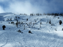
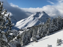
A skier noticed multiple collapses at History Rock, and snapped a photo of active wind loading at higher elevations in Hyalite. From the email: " Roughly 30cm new snow from the last storm, light winds, although Blackmore (pictured) and Flanders appeared to be getting hammered by the wind. Did a few laps in the top meadow and was getting frequent collapsing on the way back up. One felt like a small earthquake and was the loudest wumpf I've ever heard." Photo: M. Lavery
More Avalanche Details

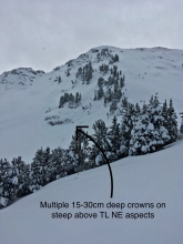
L-N-R1-D1-I
Coordinates: 45.4471, -110.9980
Caught: 0 ; Buried: 0; Killed: 0
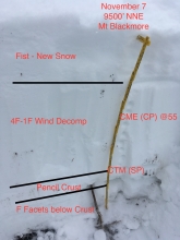
A skier in Hyalite reported many signs of new snow instability near Mt. Blackmore. From the email: "Widespread shooting cracks and wumphing. Lots of dry loose activity in steep terrain. I saw what I believe was a crown line near the ridge on the north face of Blackmore but it was hard to see because it was in the shade. The wind was gusty and not very consistent, so those wind affected slopes didn’t appear to have set up into harder slabs yet, but I wasn’t about to walk out there to find out!" Photo: H. Coppolillo
More Avalanche Details
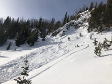
SS-N-R4-D3-I
Elevation: 8,000
Aspect: NW
Coordinates: 45.8059, -110.9360
Caught: 0 ; Buried: 0
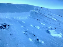
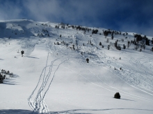
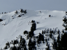
From the ridge late this morning (1/24) we saw multiple large crowns in Truman Gulch on the west side behind Bridger Bowl. Biggest was behind d-route (photo).
Two other slides visible today during brief break before more snow. One behind ridge north R2-D2, and one behind the patrol tow R3-D2.5. All 2-3.5’ deep, latter two not as wide. All big. Broke naturally, probably overnight after 1.6" of swe yesterday and moderate westerly winds. Photo: GNFAC
More Avalanche Details
Caught: 0 ; Buried: 0
Skiers touring into Specimen Creek wrote, "We got a lot of heart pounding collapses and shooting cracks."
More Avalanche Details
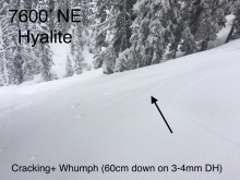
Elevation: 7,600
Aspect: NE
Caught: 0 ; Buried: 0
Skiers got collapses and cracks as they toured up Lick Creek. They reported, "1 large whumph on 26 degree NE terrain @7600’. Investigated and likely weak layer was 3-4 mm facets down 70cm with total HS 105."
More Avalanche Details
SS-R2-D1.5-I
Coordinates: 45.8271, -110.9320
Caught: 0 ; Buried: 0
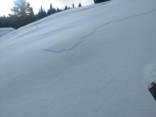
"We noticed this broken slab debris en route to ski the ramp north of Bridger Bowl yesterday. It was at the ridge line, and the crown was about 18 inches tall. It didn't slide very far, due to its lower angle (<30 degrees) and it is unclear if it slid naturally or from a skier poking over to check it out. It was located above cliffy, high consequence terrain."
More Avalanche Details

SS-AMr-R2-D2-I
Elevation: 0
Aspect: N
Caught: 0 ; Buried: 0
From an email:
" ...was riding with a guide group near the Two Top area and remotely triggered this slide as rode past this drainage on the top of the ridge. It was a north facing wind loaded slope in the 38 degree slope range. It broke about 12 inches deep and looked like it was from the last snow/wind loading."
More Avalanche Details

Elevation: 8,200
Caught: 0 ; Buried: 0
From an email: "The snowpack seems to about double by the time you get into the upper meadows. We got one loud whoomph up high around 8200’."
More Avalanche Details
SS-ASu-R2-D2-I
Elevation: 9,000
Aspect: NE
Coordinates: 45.3422, -111.3970
Caught: 0 ; Buried: 0
From an email:
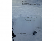
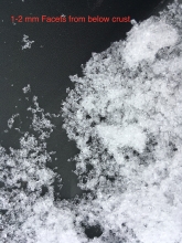
"Dug a pit at ~9000’ on a NE aspect, got a ECTP29 at 56cm down, breaking below the new snow and a 12cm knife-hard slab. Broke on small facets (<1mm) in between wind slabs. I marked the trigger point in red. Skinned up a low angle gully up to around 9500’. As I got near the steepest part of the gully (38°), a soft slab 12-18” thick propagated 100’ wide and slid 500’ back down to my pit. No one was caught. Contrary to my pit, this ENE aspect slid just the new snow on top of a previous wind slab. No facets on the bed surface, just new snow/old snow interface. Found safer skiing down low in the trees where there was less wind loading."
More Avalanche Details

Coordinates: 45.4441, -111.0030
Caught: 0 ; Buried: 0
From an email, " Over a foot of new snow up high with consistent NW winds. Soft slabs where breaking anywhere from several inches midslope to a foot deep along ridgelines on a mid-storm density change in the newest snow. We experienced cracking along ridgelines, but no collapsing while skinning in the trees or near the ridge."
More Avalanche Details
SS-NC-R2-D2-S
Elevation: 8,700
Aspect: E
Coordinates: 45.7977, -110.9340
Caught: 0 ; Buried: 0
Natural avalanche reported by ski patrol. Occurred around 1230. Likely cornice triggered. Strong winds blowing all day, drifting 20” of snow from the weekend.
More Avalanche Details
SS-N-R3-D2-I
Elevation: 8,900
Aspect: E
Coordinates: 45.7772, -110.9360
Caught: 0 ; Buried: 0
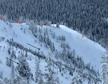
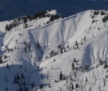
Forecaster obs: This morning on drive to Bridger we saw crowns from recent avalanches almost continuously between Bridger Peak and the Pinnacles. Probably 6 paths had avalanches. 2-3’ deep across all starting zones. Estimate they ran late yesterday or this morning due to not very covered from yesterday’s snow, and crowns from Sunday on Saddle/Argentina were covered. Saddle was in a thick cloud of blowing snow. Strong wind continued all day. Moving across mid mountain later in the day. -AM
More Avalanche Details
SS-ASr-D2
Coordinates: 45.5129, -111.0770
Caught: 0 ; Buried: 0
From email: "As we entered the large open meadows on the east face ... we remotely triggered a sizable avalanche from 2-300 yards away. The crown was approximately 100 yards wide, running several hundred yards downhill ... the crown appeared to be about 2 feet deep."
More Avalanche Details
SS-N-R2-D2-I
Aspect: N
Caught: 0 ; Buried: 0
Natural avalanches in the new snow, near Cooke City, on January 21st.
From email: "avalanche crowns on the shoulder of Mt. Republic from this morning. (saw the powder cloud at about 8:30am). I estimate the upper crown to be 1-3' deep and about 100' wide. Northerly facing terrain."
Photo Credit: B. Fredlund
More Avalanche Details
SS-AFu-D1-I
Caught: 0 ; Buried: 0
Small avalanche 70m up "The Dribbles" ice climbing route in Hyalite.
From email: "Some super heavy wind loading as the slope flattened out.... as he set up the anchor 70m up the climb a small slab came off just to his left."
More Avalanche Details
AS
Coordinates: 44.9749, -111.2940
Caught: 0 ; Buried: 0
From e-mail: "We toured for 2 days in the sunlight basin area south of the Taylor fork. High winds and sugary snow were the norm. We observed whumph-ing and large shooting cracks on our low angle (less than 20 degree) skin track on multiples slopes and aspects. A person easily sinks to their waist when stepping off their skis."
More Avalanche Details
Elevation: 6,600
Aspect: E
Coordinates: 45.5128, -110.9190
Caught: 0 ; Buried: 0
From e-mail: "Noted shooting cracks and whumpfing on an east facing aspect while skiing from Bozeman creek into wild horse and lick creek. This did occur on a forest service road cut at about 6600ft. Also, we didn’t get any propagation in our snow pits. ECTN15"
More Avalanche Details
Coordinates: 44.8703, -111.0510
Caught: 0 ; Buried: 0
From e-mail: "We rode Telemark Meadows yesterday and got a lot of collapsing under our skis."
More Avalanche Details
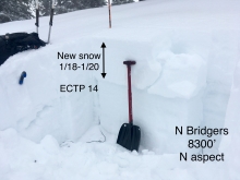
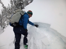
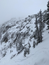
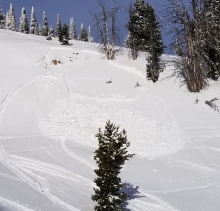
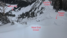
SS-N-R2-D2.5-I
Elevation: 9,000
Aspect: NE
Coordinates: 45.7946, -110.9360
Caught: 0 ; Buried: 0
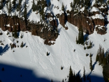
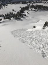
Caller reported: A natural avalanche ran down the main gut of the northeast face of Saddle Peak. Full track about 2000'. Half way down it propagated out 200-300' wide. Ran over cliffs into 'going home chute' and over lower traverse out from ski area boundary. 18-20" deep new snow. Nothing stepped down into older layers.
More Avalanche Details
SS-ASr-R2-D1.5-I
Aspect: NE
Coordinates: 45.9227, -110.9750
Caught: 0 ; Buried: 0
More Avalanche Details
SS-NC-R1-D2
Coordinates: 45.7935, -110.9360
Caught: 0 ; Buried: 0
Forecaster note: From road on drive down at 1400. Used binoculars to confirm. Saw skier/cornice triggered slide off south summit of Saddle Peak. looked like it ran down the south-central chute 1/3-1/2 way, but visibility was hard to confirm. May have gone farther. Didn't propagate wide. looked like within new snow. kind of a large volume loose snow slide. R1-D2.
More Avalanche Details
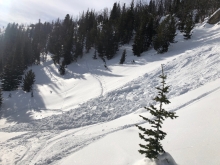
SS-N-R2-D2-U
Elevation: 8,600
Aspect: E
Coordinates: 45.7874, -110.9360
Caught: 0 ; Buried: 0
Forecaster note: From road on drive back from the Throne/northern Bridgers we saw a series of large, R2-D2 avalanche crowns (overlapping) on lookers left of center Argentina Bowl below cornices, near steep rocky cliffs in center. Used binoculars to confirm.
More Avalanche Details
Elevation: 10,000
Aspect: S
Coordinates: 45.0722, -109.9480
Caught: 0 ; Buried: 0
GNFAC Field observation
Avalanche, Chimney Rock, NW facing slope. From Daisy Pass we could make out fresh debris at same elevation as us. Could not see the crown, but upper slopes were rocky, thin and likely faceted. Visibilty was not good.
Cracking, Scotch Bonnet: We skied up a south facing slope to 10,000 and had shooting crackings in the new, wind drifted snow. The new snow is not bonding well to the old snow surface and it is breaking where it has been blown into slabs.
More Avalanche Details

SS-AS-R2-D1.5-I
Elevation: 8,900
Aspect: E
Coordinates: 45.7932, -110.9340
Caught: 0 ; Buried: 0
Caller reported: Three skier triggered avalanches reported breaking in new snow (6-8") and running 300-500' vertical. 1 between the peaks, 1 on the south peak, and 1 on the more popular run down ENE ridge. Slabs of new snow.
More Avalanche Details
SS-N-R1-D1.5-I
Elevation: 7,800
Aspect: NE
Coordinates: 45.7957, -110.9330
Caught: 0 ; Buried: 0
More Avalanche Details
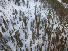
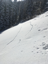
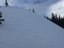
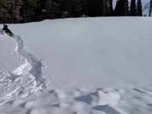
SS-ASr-R3-D1.5-O
Aspect: NE
Caught: 1 ; Buried: 1
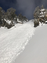
"The slide occurred near Fairy Lake in the Bridgers. Specifically, it occurred on a NE face just below the first set of switchbacks on the summer trail, where the slope steepens significantly. I was out early touring solo hoping to catch sunrise from the bowl. I'd just started traversing north along the base of the face when I saw a small slab release behind me which sent some sluff across my tracks, I turned to descend to some lower angle terrain, and saw another small release (20-30ft wide) in front of me. As I started to descend the whole face let go from about 150ft above me and funneled towards me. It carried me about 100ft downslope, luckily through an open patch in the trees. I was buried up to my chest, with both my arms free. From what I could see from the bottom, the crown looked to be about 4-8 inches tall, and was about 200ft across."
More Avalanche Details

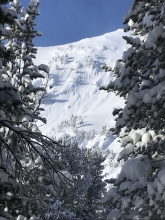
HS-ASu-R3-D2.5-O
Elevation: 10,000
Aspect: NE
Caught: 0 ; Buried: 0
From an email:
"We remote triggered this deep slab on our ascent. 10000 feet on ne aspect, slope around 40 degrees. Recently loaded and failed on advanced facets above an October ice crust. In places pulled the crust to the ground. As-hs-r3-d2.5 plus. Crown 2-3 feet flanks 400 ft. Spooky settlement."
More Avalanche Details
N-R1-D1.5
Caught: 0 ; Buried: 0
From facebook: "natural avalanche down near reynolds pass. West facing slope, it faces hwy 87 and is named mile Creek trail by usfs. No snowmobiling and haven't ever seen anyone ski it."
While this is just outside of our advisory area, it is close to the Lionhead area.
More Avalanche Details

HS-AMu-R2-D2.5
Elevation: 10,000
Aspect: SE
Coordinates: 44.9162, -111.2200
Caught: 0 ; Buried: 0
From an email:
" There was a avalanche on Sunday in Cabin Creek, it appears that a few rider's were high marking an open face, didn't see it happen but I did observe rider's from a distance in that area."
More Avalanche Details
Coordinates: 45.8221, -110.9370
Caught: 0 ; Buried: 0
From e-mail: "[In Truman Gulch]... We found a soft 4 finger layer about a foot thick over 6 to 12 inches of large grained facets that wouldn’t let us isolate a column. As we skinned up, we experienced whoomphing and cracking in the snow sometimes when the second skier crossed the pockets other times the first guy was heavy enough by himself. Nothing propagated into larger slabs..."
More Avalanche Details

WL-N-R1-D1
Coordinates: 45.4076, -110.9730
Caught: 0 ; Buried: 0
From e-mail "Inverted per temps and solar aspects were cooked with wet loose activity particularly on rockier features... More recent activity noted due to cornice fall with the increasing temperatures."
More Avalanche Details

SS-N-R2-D1.5-O
Elevation: 8,750
Aspect: N
Coordinates: 44.9605, -111.1160
Caught: 0 ; Buried: 0
From e-mail "...Surprisingly supportive trailbreaking. Isolated collapsing both low in Bacon Rind creek, and ascending under Ernie Miller. One notable whumph at 9200' near saddle, we could hear sympathetic whumphing into the distance. Triggered from a thin spot near a tree.
Numerous older slides on the lesser angled, SE and SSE asp of Ernie Miller, as well as Northerly asps of White Peak and BTL areas at the head of Bacon Rind creek.
One small slide on a N asp at head of Bacon rind creek, elev 8750, had a crisper look than most of the others observed, suspect more recent. Not a big pocket but indicative of what might still be out there waiting for a trigger, given the fact that we are still observing collapses even this long after significant loading. Photo attached.
...probing at 8300' in a sheltered open low angle meadow, E asp, found a mighty 80cm. Same setup described elsewhere in the area, about 10cm DF which is faceting out, capped by SH 3-5mm, overlying 25cm or so 1F slab, overlying very weak FC."
More Avalanche Details

HS-AMu-R3-D1.5-O
Elevation: 9,280
Aspect: SE
Coordinates: 45.1838, -111.4420
Caught: 0 ; Buried: 0
More Avalanche Details

HS-AMu-R2-D2-O
Elevation: 9,500
Aspect: S
Coordinates: 45.0632, -110.0110
Caught: 0 ; Buried: 0
More Avalanche Details
SS-N-D2.5-O
Coordinates: 44.5672, -111.5440
Caught: 0 ; Buried: 0; Killed: 0
" Yesterday, I skied into Hellroaring Canyon with a group of 6 backcountry skiers staying the night at Hellroaring Hut. While guiding the skiers to the hut, we saw large deposits of avalanche debris in the bottom of major slide paths on west and southwest facing aspects of Mt. Nemesis. It appeared that some of these avalanches were roughly size 1 - 2.5. Numerous creek bottoms and cut banks had also avalanched into Hellroaring Creek. Even some very low angle NW facing gully features had been ripped out. Looking across the valley into the Blair Lake area, I noted only one very small slide on a steep, rocky aspect. I did not have a chance to dig a snow pit, but I did observe numerous huge “whoompfs” while ski touring, and it was obvious that the faceted layer underneath last week’s 6 inches of new snow was failing regularly. "
More Avalanche Details
Elevation: 8,000
Aspect: E
Coordinates: 46.9058, -110.5850
Caught: 0 ; Buried: 0
Avalanche triggered by snowmobilers in the Little Belts on Thursday (1/10). This is outside of our advisory area, but shows many of the mountains in Montana have a weak and unstable snowpack. Photo: N. Boyer
More Avalanche Details
Elevation: 8,000
Coordinates: 44.9616, -111.0960
Caught: 0 ; Buried: 0
"I’ve been in Tele Meadows and Bacon Rind the past few days. In both places I found supportable boot top powder skiing, as soon as you stepped out of your skis however you would punch down to the ground everytime. Today there was a thin sun crust on SE facing slopes but it skied pretty well. The shaded slopes were covered in 4mm surface hoar. We observed roller balls from the day before on steep west facing slopes. We got one whoomph in the sage flats at the bottom of Bacon Rind and two good ones in the upper meadows, above 8000’."
More Avalanche Details
SS-AM-R1-D1-O
Coordinates: 45.2599, -111.1380
Caught: 0 ; Buried: 0
Riders up Portal Creek in the northern Gallatin Range experienced cracking and collapsing and possibly triggered a small avalanche. They were riding at night. Photo: N. Donovan
More Avalanche Details
U-N
Caught: 0 ; Buried: 0
"These pics of recent slides were taken in Taylor’s Fork on Wednesday 1/9/19. First one is the hill that always seems to slide in sunlight basin. I did not venture down into the basin, so unsure of the trigger. The second one is on the ridge by the burn."
More Avalanche Details
SS-AMu-R3-D2.5-O
Elevation: 9,000
Aspect: E
Caught: 0 ; Buried: 0
From a FB message:
"... on the way out if town in the truck we saw that Lionhead had a big slide before airplane hill. Must have been this morning because we didn't notice it yesterday."
More Avalanche Details
Elevation: 8,800
Caught: 0 ; Buried: 0
From an email: "Lower elevation snowpack was a wallow through deep and unsupportable facets. We were sinking 12" - 18" on skis... straight to the ground off skis. Off the road, our sled tracks were dropping down almost to the ground.
At 8200'+ the snow was a bit more supportable. No collapsing, cracking, woomphing until...
We got to 8800' and were running out of time so decided to ski out. I was going to dig a pit on a 15 degree adjacent to a steeper pitch and as soon as I stepped out on to a more cohesive slab from the shallow snowpack I was on, the whole slope collapsed and shifted downhill a few inches (See photo). Didn't dig the pit... turned around, traversed to the trees, and slid home. Based pole and hand pit, the slab seemed to be about 1F - 4F over 18" - 24" Fist hardness facets.
The difference between the slope that collapsed and the rest of the tour was the slab. There had been recent windloading and the slab was more cohesive."
More Avalanche Details
SS-N-R3-D2-O
Elevation: 9,000
Caught: 0 ; Buried: 0
Many avalanches broke during the last week's avalanche cycle at Lionhead. Natural and snowmobile triggered slides were reported between 1/7 and 1/9. On 1/6-1/7 the area got a foot of heavy snow followed by strong winds. This loaded an unstable snowpack that is poorly supported by 1.5' of sugary snow on the ground. Avalanches broke 2-3 feet deep on this weak snow, and propagated relatively wide.
More Avalanche Details
SS-AMr-R2-D2
Elevation: 9,000
Aspect: SE
Coordinates: 44.7333, -111.3250
Caught: 0 ; Buried: 0
A snowmobiler triggered this small, but deep avalanche as he rode under the slope.
From his email, "We were riding as a group of 5. All with beacons ,shovels, probes and 4 with inflate packs. The hill broke as I was side hilling. I was just ahead of it and not knocked off the sled."
More Avalanche Details
Coordinates: 44.5494, -111.5080
Caught: 0 ; Buried: 0
A sledder remote triggered several slides from the bottom of a south facing slope in the Centennial Range, Hell Roaring Creek.
More Avalanche Details
SS-AMr-R3-D2
Aspect: E
Caught: 0 ; Buried: 0
Snowmobilers near lionhead witnessed three avalanches on Jan 7, 2019. One natural and two remotely triggered.
From email: "We had been climbing a safe slope adjacent to this slide... 24 inch crown and about 200 feet wide... Occurred at 1:38PM on an easterly wind loaded slope...The third slide... was triggered when the group passed below a short steep slope. We were well spaced and using safe practices when the number 6 sled in line remote triggered the avalanche. It flowed across our tracks and was about 12 inches deep. No one was caught or threatened.... on a southeast aspect."
More Avalanche Details
Caught: 0 ; Buried: 0
From email "We found really unstable snow, slopes settling on the faceted ground layer and shooting cracks propagating across the smallish open snowfields between tree clumps. It was really scary. We turned around about 100' below the ridge and cautiously skied out the way we'd skinned up.... 300' below the ridge... On one open slightly steeper section my two partners heard whoomping (after I crossed the slope)."
More Avalanche Details
SS-ASc-D1
Coordinates: 45.3397, -111.3950
Caught: 0 ; Buried: 0
From email: "We did set off one small slide on a steep slope skiing back into Beehive from the Middle Ridge. It was approximately 1 foot deep, 20 feet across and ran ~50 feet. It was very predictable and my partner got it to run after stomping on the slope."
More Avalanche Details
HS
Elevation: 9,700
Aspect: NW
Coordinates: 45.0006, -109.9550
Caught: 0 ; Buried: 0; Killed: 0
Skiers on Republic Mountain "noted one recent, natural wind slab avalanche on a NW aspect around 9,700', from a localized east wind". They also observed collapsing on wind-loaded slopes near the ridge.
More Avalanche Details
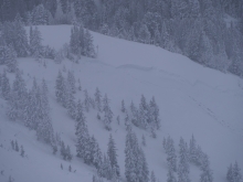
HS-N-R2-D2
Aspect: NE
Coordinates: 45.8580, -110.9540
Caught: 0 ; Buried: 0; Killed: 0
This avalanche was on a northeast slope on Ross Peak. The observation reported "very firm thick wind slabs with ground level facets" nearby. Photo: J. Johnson
More Avalanche Details
HS-AMu-R2-D2-O
Elevation: 8,000
Aspect: E
Coordinates: 45.8670, -110.9540
Caught: 0 ; Buried: 0
A rider reported: "I had just rode up and was on my way down when it broke off right beside me. I was approximately 80 yards to the north of the slide when it broke."
More Avalanche Details

SS-ASu-O
Caught: 0 ; Buried: 0
From e-mail: "We went up to Fairy Lake yesterday... to the north facing trees right off of the lake. The wind has really done a number on the whole area, I haven't seen it like this before. Anyway we started up and the snow was really weird. We'd be on top of a hard wind slab and then ten feet later punch through it and be wallowing in sugar up to our knees.... the weirdness continued as we tried working east and west across the face looking for more stable snow. After we'd climbed about 350 feet above the lake I had a big whoomp and the snow I was on collapsed about a foot, and cracks shot out about 50 feet from me. This was at about 8:30 yesterday morning."
Seperate group, same area: "ECTP 3 on a northwest exposure. Snow depth was about 60 cm where this test was taken. Dug another pit on same aspect with a 120cm base, which fractured at 27 hits, but did not propegate."
More Avalanche Details
Coordinates: 45.4725, -110.9500
Caught: 0 ; Buried: 0
"Witnessed this road cut collapse in hyalite today , by the Palisades parking lot. Easily a foot of dense snow on 12-18" of sugar. Audible collapse as my dog climbed the embankment." C. Bieniek
More Avalanche Details
SS-AMu-R2-D1.5-O
Elevation: 8,000
Aspect: S
Coordinates: 44.5298, -111.4930
Caught: 0 ; Buried: 0
From e-mail: "This was a snowmobile triggered slide in a S aspect in the Blue Creek Drainage SE of Reas Peak in the Centennials. No one was caught and no injuries"
More Avalanche Details
SS-ASu-R3-D2-O
Elevation: 9,400
Aspect: E
Coordinates: 45.3332, -111.3830
Caught: 0 ; Buried: 0
We found this fresh skier triggered avalanche in Middle Basin today 1/5/19. East aspect. 9,400’ elev. It broke 1-2’ deep on weak, sugary facets. We had stable results in our stability tests (so did another group nearby), but this slide and recent reports of collapsing in the area indicate an untrustworthy and unstable, poor snowpack structure.
This avalanche was triggered by the second skier down the slope. Nobody was caught.
More Avalanche Details


SS-AMu-R2-D1.5-O
Coordinates: 44.8887, -111.1580
Caught: 0 ; Buried: 0
More Avalanche Details

SS-AS
Elevation: 9,800
Aspect: W
Coordinates: 45.3352, -111.3840
Caught: 0 ; Buried: 0
From e-mail: " in bhive today, as I rolled into a W facing gully at around 9800ft I got a good whumph, I noticed a 25ft wide crack probably about 8 inches deep, it did not run just fractured. I checked it out seemed like it broke on an older slab sitting on that facet layer from early December."
More Avalanche Details
HS-N-R3-D3-O
Aspect: E
Coordinates: 45.7690, -110.9410
Caught: 0 ; Buried: 0; Killed: 0
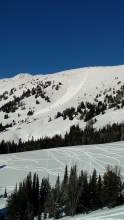
Multiple avalanches released on wind-loaded slopes in the Bridger Range south of Bridger Bowl. The largest propagated a few hundred feet wide on Bridger Peak. Smaller slabs released in the Pinnacles and in Argentina bowl.
More Avalanche Details
SS-AE-R2-D1-I
Elevation: 81,000
Aspect: SE
Coordinates: 45.8092, -110.9280
Caught: 0 ; Buried: 0
More Avalanche Details
Coordinates: 45.3161, -111.3720
Caught: 0 ; Buried: 0
Extreme whoomphing while breaking trail along Bear Basin yesterday. Extremely faceted snow forming and producing unstable snowpack about a foot+ deep. Andrew Belli
More Avalanche Details
SS-N-R2-D2
Elevation: 9,300
Coordinates: 45.4339, -110.9950
Caught: 0 ; Buried: 0
From email on 1/3/19: "On [January] 2nd, there were 4 older natural avalanches on N slopes in the Alowe basin as well as 1 recent avalanche below the NW couloir. I've attached a pic of an older slide on the SW aspect of elephant. I also got some collapsing as I skinned up the south side of the bmor/elephant saddle on the 3rd."
More Avalanche Details
Coordinates: 45.5109, -111.0760
Caught: 0 ; Buried: 0
Skiers reported collapsing on their approach to Wheeler Mountain. From the email: " Within the the first 50 vertical feet ascending, we experienced two significant collapses/ ‘whumphing’. No signs of avalanche from the previous party’s fun looking tracks."
More Avalanche Details
Elevation: 9,400
Aspect: SW
Coordinates: 45.3270, -111.3250
Caught: 0 ; Buried: 0
Skiers on Wilson Peak observed "widespread whoomfing and could visibly see the slopes drop/collapse on the climb through the trees". They dug a pit and found facets buried 40 cm deep and unstable test results at ECTP23.
More Avalanche Details
Coordinates: 45.5241, -110.9560
Caught: 0 ; Buried: 0; Killed: 0
Skiers in Lick Creek found buried facets and experienced collapsing today. From the email: "Found the same snowpack as Eric observed on Mt. Ellis yesterday. The meadow this morning was south facing. Almost all open areas had the recent new snow sitting on top of facets to the ground. Supportable enough to ski. Heard a couple whumpfs skinning up on steeper sections. No wind impact."
More Avalanche Details
N
Aspect: E
Coordinates: 45.3911, -110.9530
Caught: 0 ; Buried: 0; Killed: 0
Skiers saw an avalanche that released shortly after the New Year's storm cycle. From the email: "Snow was good below tree line and was nuked by the wind above tree line. Lots of variability. At Hyalite Lake we looked to our right at a slope (east facing?) and there was an avalanche that probably released 2 to 4 days ago. See attached photo. Probably 1 to 1.5 ft crown. Didn’t run far. We kept our slope angles less than 30 degrees and dug up above the lake. ECTN 22 about 40 cm down. Wind slab and new snow on small facets." Photo: K. Birkeland
More Avalanche Details
Coordinates: 45.5775, -110.9560
Caught: 0 ; Buried: 0
Skiers on Mt. Ellis noticed unstable conditions on New Years Day, experiencing multiple collapses. Test pits yielded unstable results, and they found "the base of the old/faceted snow was comparatively better consolidated but got progressively weaker near the top and would barely stay in the pit wall just under the ~14” of newer snow."
More Avalanche Details
Coordinates: 45.2859, -111.2840
Caught: 0 ; Buried: 0
"Wide spread whomping and cracking especially near ridge tops" noted in Dudley Creek on 1/1/2018.
"Ridge lines and wind loaded areas were very touchy and produced small slabs but they seemed isolated to certain slopes." noted in Beehive on 12/31/2018
More Avalanche Details
HS-N-R2-D2-O
Coordinates: 45.0553, -109.9600
Caught: 0 ; Buried: 0; Killed: 0
Multiple slab avalanches released on Crown Butte in Cooke City on slopes loaded by new snow and wind over the past few days. Photo: T. McCoy
More Avalanche Details
Coordinates: 45.5925, -110.9590
Caught: 0 ; Buried: 0
Eric got a lot of collapsing and cracking as he climbed up through the trees towards the ridge between Little Ellis and Main Ellis. New snow on a shallow and weak snowpack are creating instability.
More Avalanche Details

SS-N-R2-D2-O
Aspect: E
Coordinates: 44.7243, -111.3210
Caught: 0 ; Buried: 0
This avalanche in Airplane Bowl off Lionhead Ridge, is south facing at 9,000'. The avalanche was 1-2' deep, 100' vertical and 150' wide (estimated). It likely broke late Sunday or Monday (12/31), during or immediately after the Avalanche Warning. Weak, faceted snow could not support the weekends snowstorm and there were widespread slides. Many of the crowns and debris piles were covered over with wind drifted snow, but there were many slides off the ridge on the facets.
More Avalanche Details

SS-N-R2-D1.5-I
Coordinates: 45.3923, -110.9700
Caught: 0 ; Buried: 0; Killed: 0
Skiers in Hyalite saw recent slab avalanches that failed below the most recent snow. They observed recent activity on "East, South and Northerly aspects in the Divide and Hyalite basins". Photo: C. Kussmaul
More Avalanche Details

SS-AMu-R1-D1.5
Aspect: E
Caught: 0 ; Buried: 0
A snowmobiler triggered this slide in the 3rd Yellowmule of Buck Ridge on Monday (12/31). It was an east facing slope.
More Avalanche Details
SS-N
Coordinates: 45.3475, -111.4000
Caught: 0 ; Buried: 0
From an email:
"...observed lots of natural avalanches in Beehive Basin today. My partner counted 12+ including this one... All avalanche activity was on E or NE slopes which had been hammered by the winds. We found soft, more stable (ECTX) snow on SE aspects, although still found the bottom 2’ of snowpack to be rotted into <1mm facets, resting below the fresh 2’ slabs. Not reactive in our tests but there was lots of collapsing and this layer will become an issue with a heavier, more cohesive load."
More Avalanche Details
SS-N
Coordinates: 45.2499, -111.3740
Caught: 0 ; Buried: 0
From the Yellowstone Club Ski Patrol, " ...we noted 2 natural avalanches along one of our roads. They both are at about 7000ft and had a relatively shallow snowpack. The crowns were roughly 2ft in depth and ran on facets near the ground. One slide looks like it released during the yesterday’s storm and the other appears to have gone either overnight or this morning. Patrollers also spotted a natural avalanche outside of the ski area boundary in the Eglise Bowl. The photo was taken from a distance but the aspect is NE and the elevation is around 8500ft." Photo: YCSP
More Avalanche Details

SS-N
Caught: 0 ; Buried: 0
From an email:
"Today we skied on the southeast end of Scotch Bonnet. We saw some naturals further west (the Rasta chutes) and on some of the other big features of the region (on sheep west face and the peak just south of lulu pass). All on scotch bonnet appeared to be involving storm snow though the further ones could have involved deeper layers."
More Avalanche Details
Coordinates: 45.5778, -110.9530
Caught: 0 ; Buried: 0
Party 1: Splitboarders on a dawn patrol got cracking and collapsing as they ascended Mt. Ellis. This occurred as they popped out of the trees at 7,600' so they stuck to lower elevation slopes. The snow stability worsened from their trip the day before. New snow and wind-loading made conditions ripe for cracks and whumphs.
Party 2: from an email, "...skinned up Little Ellis from the north today. We went up into some of those clear cuts that are visible on that side. Not surprisingly, the snow was pretty thin, with an HS of around 60 to 70 cm. The bottom 20 cm or so was total junk facets. We were getting large collapses breaking trail that were shaking bushes 30 or 40 feet away. Every time we got into some fresh snow we would get a good collapse. We were in low angle terrain (about 25 deg at the steepest), but if it had been steeper I would have been obviously pretty worried."
More Avalanche Details
SS-R1-D1
Coordinates: 45.8829, -110.9510
Caught: 0 ; Buried: 0
Slides were skier triggered. Wind-loaded from new snow. They triggered two in that area on the steeper rollovers. One in that main south facing chute and another on the face above sled parking.
More Avalanche Details

SS-N-R1-D2-I
Aspect: E
Coordinates: 45.0051, -109.9570
Caught: 0 ; Buried: 0
A natural avalanche was seen on the Fin of Mt. Republic on 12/31(Mon). Skiers also remotely triggered 2-4 inch deep avalanches in the new snow from 100+ feet away in Yellowstone National Park on 12/30 (Sun).
Also, " One skier triggered slide on a west aspect of Woody also observed, from yesterday (12/30) (6-12" deep and 50' wide)."
More Avalanche Details
SS-N-R1-D1-I
Elevation: 7,800
Coordinates: 45.9217, -110.9850
Caught: 0 ; Buried: 0; Killed: 0
Skiers in the northern Bridgers noticed this natural slab avalanche. From an email: "Extremely weak, faceted snowpack on w-e slopes all the way up to 8000ft or so. Widespread cracking and collapsing, basically a 14in storm slab on top of total garbage. Observed a good size natural in steep, north facing terrain at about 7800ft, starting zone was a big slough fan and broke what looked like 2-3ft deep, presumably on the dry spell facets."
More Avalanche Details
SS-ARc-R1-D1-I
Coordinates: 45.4164, -110.9700
Caught: 0 ; Buried: 0; Killed: 0
Riders in Hyalite observed collapsing and propagating of the new snow near Maid of the Mist. They also found unstable test results (ECTP7).
More Avalanche Details

SS-AS-R1-D1-I
Coordinates: 44.9739, -109.9240
Caught: 0 ; Buried: 0; Killed: 0
This small slab was triggered by a skier and failed at the new snow interface.
More Avalanche Details
SS-ASc-R1-D1-I
Coordinates: 45.4441, -111.0030
Caught: 0 ; Buried: 0; Killed: 0
Skiers near Blackmore found the new snow failing at the new/old snow interface. They were able to trigger these soft slabs with a ski pole whack.
More Avalanche Details
HS-R1-D1.5
Coordinates: 45.8529, -110.9450
Caught: 0 ; Buried: 0
Debris from an avalanche that failed during the December 27-29 storm.
More Avalanche Details
Coordinates: 44.8374, -111.3410
Caught: 0 ; Buried: 0
On any slope that had old slabs of wind drifted snow we experienced large collapses and shooting cracks.
More Avalanche Details

Elevation: 8,000
Caught: 0 ; Buried: 0
From an email from Bret Rasmussen:
(Collapsing) "This occurred as I was driving through the snow. I had observed this evidence of collapsing in a few areas, but in the picture I actually witnessed the snow settle. Above and South of Watkins Creek. East Southeast aspect. 8000 feet."
His assessment (we concur): " The weak layer does not seem to be healing... It's going to take a deeper snow pack to promote stability but at the same time this will stress the existing weak layer. I'm afraid we are headed for a very troubled avalanche season!"
The attached video and snowpit is from the same day, not very far to the north in Trapper Creek.
More Avalanche Details
SS-AMu-R1-D2-O
Aspect: S
Coordinates: 45.0790, -110.0200
Caught: 0 ; Buried: 0
The avalanche on the south face of Mt Abundance was set off at about 2:00 pm on Thursday. A rider realized he triggered a slide on his way back down the slope. It was estimated to be at least 1+ foot deep, 100 feet wide, and ran 100 feet slope distance. It was big enough to bury a person.
This depth (est. 1+') is similar to the faceted layer that was unstable near Lulu Pass the day before (ECTP22).
More Avalanche Details
SS-ASc-R1-D1
Caught: 0 ; Buried: 0; Killed: 0
Skiers intentionally triggered small wind slabs that were 2-3" deep and up to 20 ft wide that did not run very far. They also reported low-volume dry loose activity.
More Avalanche Details
HS-ASu-R3-D3-O
Elevation: 9,800
Aspect: N
Coordinates: 45.2629, -110.7070
Caught: 0 ; Buried: 0
More Avalanche Details
Coordinates: 44.5778, -111.5370
Caught: 0 ; Buried: 0
"I was in the Hellroaring Drainage Yesterday, snow depths below 7,000' hover around 18", around 8,000' snow depths increase significantly but are still shallow i.e. less than 30". Witnessed the largest "whoomphs" I have ever felt (that's saying something since last Decemeber/Jan was horrendous), interestingly much of this was felt returning on the same skin track, telling me this is a stubborn layer that may not give right away. The largest was a collapse in a meadow nearly 0.25 miles long."
More Avalanche Details
SS-AMu-R1-D1
Aspect: S
Coordinates: 45.1933, -111.4410
Caught: 0 ; Buried: 0
About an 8 inch slab triggered by snowmobilers. South facing slope in the 3rd yellowmule at buck ridge.
More Avalanche Details
AS
Coordinates: 44.9694, -111.0970
Caught: 0 ; Buried: 0
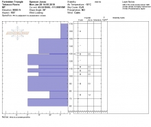
From e-mail: "We got 3 whoomphs once we got into the upper meadows, where there was enough snow for a good slab on top of the facets that make up the majority of the snowpack, down low the snowpack was weak and thin but lacked a supportable slab. We dug a pit on an east facing slope up high and got an ECTP 15@ 10cm from the ground." Pit attached.
More Avalanche Details
HS-AMu-R1-D2
Caught: 0 ; Buried: 0
A snowmobnler triggered this avalanche in the 2nd Yellowmule of Buck Ridge. No one was caught.
More Avalanche Details
HS-AM-R1
Aspect: E
Coordinates: 45.0711, -109.9570
Caught: 0 ; Buried: 0; Killed: 0
Riders triggered avalanches on wind-loaded slopes that were 20-100 feet wide near Lulu pass.
More Avalanche Details
SS-ABc-R2-D2-O
Caught: 0 ; Buried: 0
The Big Sky and YC Ski Patrols triggered numerous avalanches during control work. Most slides were fresh wind slabs created by the 4-6" of new snow and strong winds. Most stayed confined to the upper layers of the snowpack, but one slide at the YC broke on facets near the ground. This slide broke 2-3' deep and ran nearly full path.
More Avalanche Details
HS-ASc-R2-D2-O
Elevation: 8,700
Aspect: NE
Coordinates: 45.7699, -110.9390
Caught: 0 ; Buried: 0; Killed: 0
This wind slab avalanche released as a result of an intentional ski cut. The initial slab that released triggered a larger slab that ran close to 2000 feet. From the skier:
"At around 12:30 I ski cut the top of a NE facing gully on Bridger Peak, roughly 35°. A hard slab broke 6”-12” deep, around 100’ wide. This broke a secondary slab on a NNE aspect adjacent to the first one, around 300’ wide. The slide ran through trees and a gully, traveling close to 2000’ vertical into some lower angle terrain. It broke on the layer of facets that formed last week during the cold weather."
More Avalanche Details

SS-N-R1-D1-I
Aspect: SE
Coordinates: 45.8332, -110.9370
Caught: 0 ; Buried: 0
From an email:
"Natural slide on Northern wall of the Hourglass in Northern Bridgers. No tracks in or out. Crown looked to be 8-10” deep and 25-30ft wide."
More Avalanche Details
SS-N-R1-D1.5
Coordinates: 45.0163, -109.9260
Caught: 0 ; Buried: 0
Multiple natural wind slabs, likely triggered by cornice falls over the weekend.
More Avalanche Details
SS-ABc-R3-D2-G
Elevation: 8,400
Aspect: NE
Coordinates: 45.2425, -111.4290
Caught: 0 ; Buried: 0
Ski patrol triggered this avalanche at the Yellowsone Club on Sunday (12/16). "8400’, ENE facing, 36deg start zone that was about 120’ wide and ran vertically 200’. The crown was 1.5-2’, went to ground, and was a mostly faceted snowpack with a bit of wind effected snow in the top few inches. The slide was released from a 4lb air blast." -YCSP
More Avalanche Details
HS-AMu-R2-D2-O
Elevation: 9,400
Aspect: N
Coordinates: 45.1821, -111.4130
Caught: 0 ; Buried: 0
This avalanche was around the corner from the snowpit we dug in 2nd Yellowmule. It looked as though it was triggered about the same time we were digging. The slide failed on near-surface facets that formed 10 days ago that are underneath a hard slab of wind-drifted snow.
More Avalanche Details


HS-AMu-R3-D2-O
Elevation: 9,100
Coordinates: 45.1633, -111.3100
Caught: 0 ; Buried: 0
A snowmobiler triggered this slide yesterday while sidehilling on the leeward side of a ridge. Estimated crown was about 50' wide and broke about 12-18” deep.
More Avalanche Details
AS-O
Aspect: W
Coordinates: 45.8172, -110.9310
Caught: 0 ; Buried: 0
Strong winds created 12-18" thick wind drifts that collapsed on buried facets and surface hoar. We had one crack 30' wide as we left a snowpit.
More Avalanche Details

HS-NC-R2-D2
Elevation: 9,100
Aspect: E
Coordinates: 45.3223, -111.3810
Caught: 0 ; Buried: 0
More Avalanche Details
N-R3-D3-O
Elevation: 9,500
Aspect: NE
Coordinates: 44.9395, -111.1480
Caught: 0 ; Buried: 0
More Avalanche Details
HS-AO-R2-D1-O
Elevation: 9,200
Aspect: SE
Coordinates: 45.0450, -109.9180
Caught: 0 ; Buried: 0
More Avalanche Details
SS-ASc-R1-D1
Elevation: 8,400
Aspect: NE
Coordinates: 45.8288, -110.9330
Caught: 0 ; Buried: 0
More Avalanche Details
SS-ASc-R1-D1-I
Aspect: SW
Caught: 0 ; Buried: 0
From an email:
- Triggered small windslab in SW facing gulley at 9000' approximately 6" by 20'wide
- No collapsing or cracking of the snowpack observed, other than the isolated wind slab.
More Avalanche Details
SS-N-R2-D2-I
Elevation: 10,000
Aspect: E
Coordinates: 45.4438, -111.0020
Caught: 0 ; Buried: 0
Two obvious avalanches released naturally in the late morning while we were in the bowl. Upwards of 8" of new snow fell with winds gusting 30-40 mph from the west.
More Avalanche Details

HS-AF-R1-D1-I
Aspect: W
Coordinates: 45.4292, -110.9550
Caught: 0 ; Buried: 0
More Avalanche Details
SS-AFc-R1-D1-I
Aspect: NW
Coordinates: 45.4395, -110.9620
Caught: 0 ; Buried: 0
From e-mail: "The wind picked up after noon today and we observed moderate amounts of blowing snow at and above tree line. My climbing partner and I were able to trigger a small loaded pocket between slot corner and curtains, 30 deg, NNW aspect, which failed 6 inches deep and 15 ft wide on diurnal facets (old snow surface). The slab didn't move much due to the stubborn angle..."
More Avalanche Details
SS-ASu-R1-D1-I
Caught: 0 ; Buried: 0
Skiers descending Imp Peak in the southern Madison Range triggered this small wind slab. This is bull's eye information that larger slides are possible on wind loaded slopes.
More Avalanche Details
SS-ASc-R2-D1-S
Elevation: 9,000
Coordinates: 45.4128, -110.9780
Caught: 0 ; Buried: 0
From e-mail: "We bailed on plan A ( bigger couloir ) because of the visual signs of rapid wind loading. We proceeded to plan B and started getting shooting cracks on small convex rollers. We found a nice small test slope and remote triggered a decent fresh windslab. It was surprising the energy it ran with. We decided to bail on plan b and head home. Remote triggered another smaller wind slab turning around."
More Avalanche Details
SS-AS-R2-D1.5
Elevation: 10,000
Aspect: S
Coordinates: 45.3525, -111.4000
Caught: 0 ; Buried: 0
From e-mail: "We encountered very localized loading that easily fractured and propagated uphill on a south aspect (photos) then bailed on the E/NE facing run we had hoped to ski, due to a 12-18" slab at the top, obvious wind loading throughout the whole thing (9900'-10300'), and the aforementioned obvious signs of instability. When we turned around, another similar-sized (4-8" by 10-20') slide had occurred on the same aspect as the one we had triggered. Neither ran more than 100' or so."
More Avalanche Details
SS-N-R1-D2-I
Coordinates: 45.3930, -110.9690
Caught: 0 ; Buried: 0
A skier writes, "Lots of blowing snow with multiple natural avalanches occurring during the morning."
More Avalanche Details
L-ASc-R1-D1-S
Elevation: 9,000
Aspect: SW
Caught: 0 ; Buried: 0
More Avalanche Details
L-ASu-R1-D1-S
Elevation: 9,500
Aspect: SW
Coordinates: 45.3448, -111.3880
Caught: 0 ; Buried: 0
From e-mail: "triggered a small wet slide in the Going Home chute coming back into Beehive, and we observed another natural wet slide on a similar aspect that had occurred since we toured past in the morning. Wind was light or calm all day and wind effect was minimal even at ridgelines."
More Avalanche Details
Avalanche activity from new snow. Wind slabs 6-8" deep and loose snow avalanches. Natural and skier triggered. Reported in Hyalite, Beehive and Bridger Range.
More Avalanche Details


SS-ASu-R2-D2-I
Coordinates: 45.3498, -111.3850
Caught: 0 ; Buried: 0
From e-mail: "Today while skiing Bat Ears Couloir in Bear Basin we encountered fast moving 12" deep wind loaded sluff however, it didn't step down."
Second e-mail: "Upon entering the couloir I performed a ski cut and released an 8 inch deep slab that was about 12 feet wide that ran about 700 vertical. Then we skied the slide path down and safely returned into beehive by exiting down bear basin. "
More Avalanche Details

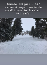
SS-N-R2-D2-I
Elevation: 8,300
Aspect: E
Coordinates: 45.8425, -110.9330
Caught: 0 ; Buried: 0
From an email:
"We did observe a natural slide at around 8300ft that failed on the high pressure facets that formed prior to these last two shots of snow. It appears that it was triggered by a slough from steeper, rocky terrain above, the crown was about 14 inches deep and around 50ft wide, in complex rocky terrain. The debris pile was approx. 200cm deep, plenty deep to bury a person. We skied 35+ degree slopes and found excellent stability the day after the storm. "
More Avalanche Details
SS-N-R2-D1.5-I
Elevation: 8,800
Aspect: N
Coordinates: 45.4468, -110.9880
Caught: 0 ; Buried: 0
More Avalanche Details
HS-N-R1-D1
Elevation: 9,500
Aspect: E
Coordinates: 45.4443, -111.0000
Caught: 0 ; Buried: 0
From an email:
"Went up to Blackmore for a pre-Thanksgiving dinner walk yesterday. Winds had moved a good bit of snow since Wednesday and I observed debris from several avalanches on the east face...Most of the slides were thin, probably fresh wind slabs failing on the latest batch of NSFs. The largest slide had some pretty sizeable chunks of hard slab style debris in it."
More Avalanche Details
WL-ASu-I
Elevation: 9,500
Aspect: SE
Coordinates: 45.4237, -110.9960
Caught: 0 ; Buried: 0
From an email:
Today, at around 11am, my partner preformed a ski cut on the top of a gully. The area he cut was south facing and in direct sunlight. The slough from his cut gained momentum and formed a small avalanche that went down the entire gully and apron, taking all of the previous days snow with it. The avalanche went on the old snow sun-crust, and new snow interface. We ascended from the back and found very stable results in both our pits, although they were both high and north facing. No one was caught or injured.
I had already skied down part of the slope in another gully, that was entirely shaded, and produced no snow movement.
More Avalanche Details
SS-AMu-R1-D1-O
Elevation: 9,500
Aspect: E
Coordinates: 45.0699, -109.9580
Caught: 0 ; Buried: 0
A snowmobiler triggered this small wind slab near Lulu pass outside of Cooke City. Wind loaded slopes are main avalanche concern across the advisory area.
More Avalanche Details
HS-N-D3.5-O
Elevation: 10,000
Aspect: N
Coordinates: 45.2843, -111.4410
Caught: 0 ; Buried: 0
From BSSP: "The 1st, 2nd and 3rd Fork had failed as a unit taking out all of the early November snow, failing on facets above the October crust. It ran far, taking out some mature trees and depositing a wide swath of debris 6-10’ onto the Merriweather ski run. It was estimated to be a Size 3.5."
More Avalanche Details
SS-AS-R1-D1-S
Elevation: 8,300
Aspect: NE
Coordinates: 45.8291, -110.9340
Caught: 0 ; Buried: 0
Strong winds in the Bridger Range formed dense slabs on leeward slopes. Yesterday, A skier north of Bridger Bowl triggered multiple wind slabs near the top of Wolverine Bowl. The skier turned around and chose a safer objective. Photo: S. Whitefields
More Avalanche Details
SS-AFu-R0-D1-O
Elevation: 9,000
Aspect: SE
Coordinates: 45.4429, -110.9320
Caught: 0 ; Buried: 0
Climbers triggered this very small wind slab on the way to a climb up Flanders in Hyalite (11/11). A tiny slide to a skier can be bad news for a climber since losing one's balance or getting pushed off a cliff can be deadly. From an email (edited):
Photo: S. Magro
More Avalanche Details
SS-ARu
Coordinates: 45.3365, -111.3810
Caught: 0 ; Buried: 0
From Instagram @chartierk:
"Careful out there this year! While we are lucky enough to have a mostly stable snowpack here in Southwest Montana, we did just find this little wind slab well below the ridge line in Middle Basin. Slowboarder was fine"
More Avalanche Details
SS-AFu-R1-D1-S
Aspect: W
Coordinates: 45.4398, -110.9540
Caught: 0 ; Buried: 0
Ice climber triggered. From e-mail: "Was descending off of Zach Attack tonight and set off a small slab in the gully on the decent. This was about 100 meters below the start of pitch 1. Constant whipping winds and lots of new deposited snow likely caused the slab to form. Climber caused. Didn’t carry me as it was small. Would be wary of the mummy cooler gullies abover scepter as well."
More Avalanche Details
SS-N-R1-D1
Aspect: NE
Coordinates: 45.4441, -111.0030
Caught: 0 ; Buried: 0
More Avalanche Details
SS-N-R2-D2
Coordinates: 45.3827, -110.9550
Caught: 0 ; Buried: 0
More Avalanche Details
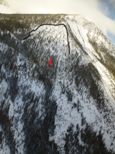
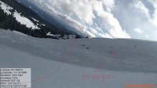
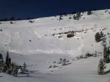
HS-ABc-R3-D2-O
Elevation: 10,901
Aspect: N
Coordinates: 45.2783, -111.4490
Caught: 0 ; Buried: 0
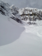
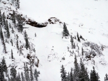
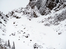
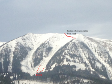
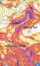
"We triggered a large avalanche in the Cirque with a 5lb. shot dangled from the Tram. The slide broke 3’ deep and took out the Dobies, Cron’s and part of the Ramp Shot avalanche paths. Hard slab- 1F minus generally. Storm slab from the past 8 days. The slide ran on a crust that formed from the left over snow from mid- October that got warmed in the 3rd week of October. The weak layer was just a thin layer of lower density snow trapped under the hard slabs- didn’t seem to be particularly faceted. Some grauple. The crust is not very hard or slick, about 2cm thick, and crumbled easily in hand... The slide had good propagation and the crown was at least 300’ long- impressive debris pile." -Big Sky Ski Patrol
More Avalanche Details
SS-N-R2-D2-S
Elevation: 8,200
Coordinates: 45.8192, -110.9280
Caught: 0 ; Buried: 0
More Avalanche Details
SS-N-R1-D1-S
Coordinates: 45.3930, -110.9570
Caught: 0 ; Buried: 0
More Avalanche Details

SS-N
Coordinates: 45.9348, -110.9890
Caught: 0 ; Buried: 0
From the MSU Backcountry Club in Instagram:Warning! This is a current, fresh, crown in the northern Bridgers! Every aspect had a visible crown and avi debris! This crown was 56cm at it deepest and over 8 meters long. ECTP21@53 and CT24@54 on the overlying slab.
More Avalanche Details
SS-N-R2-D2
Elevation: 10,900
Aspect: NE
Coordinates: 45.2792, -111.4500
Caught: 0 ; Buried: 0
Avalanche happened around 1100hrs
More Avalanche Details